Trail Walking Oberdrauburg - Lac de Wildsee - Photo
© OpenStreetMap contributors
Length
Length
6 km
Max alt
Max alt
2267 m
Uphill gradient
Uphill gradient
967 m
Km-Effort
Km-Effort  
15.7 km
Min alt
Min alt
1294 m
Downhill gradient
Downhill gradient
4 m
Boucle
Boucle
No
Creation date :
2024-06-18 08:55:58.159
Updated on :
2024-06-18 14:26:43.839

(0 Reviews)

Walking
Walking
5h30
Difficulty : Difficult

Scan this QR Code to open this trail in the SityTrail application

FREE GPS app for hiking

Logo SityTrail SityTrail

IGN / Geographical institutes

Download SityTrail from the App Store Download SityTrail from Google Play

Logo SityTrail SityTrail World

The world is yours!

Download SityTrail from the App Store Download SityTrail from Google Play Download SityTrail on Huawei AppGallery

About

Trail Walking of 6 km to be discovered at Carinthia, Bezirk Spittal an der Drau, Oberdrauburg. This trail is proposed by Tommy Eric.

Description

superbe rando, environ 1000 mètres de dénivelé.

Elevation profile

Positioning

Country:
Austria
Region :
Carinthia
Department/Province :
Bezirk Spittal an der Drau
Municipality :
Oberdrauburg
Location:
Unknown
Start:(UTM)
345688 ; 5181579 (33T) N.

Trails nearby

Trail Walking Oberdrauburg - Samedi Chemin vers Wildsee - Photo
Walking
Tommy Eric

Walking

Medium
Oberdrauburg, Carinthia, Bezirk Spittal an der Drau, Austria
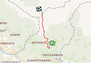
3.7 km | 10.8 km-effort
3h 24min
No
Trail Walking Oberdrauburg - rando 1 - Photo
Walking
Tommy Eric

Walking

Medium
Oberdrauburg, Carinthia, Bezirk Spittal an der Drau, Austria
4.9 km | 7.2 km-effort
3h 6min
No


Close
My subscriptions