Trail Walking Meaux - Le chemin de St Colomban en Ile de France Etape 3 Jouarre Meaux - Photo

Le chemin de St Colomban en Ile de France Etape 3 Jouarre Meaux

 chessyca
chessyca

User

© OpenStreetMap contributors
Length
Length
36 km
Max alt
Max alt
166 m
Uphill gradient
Uphill gradient
539 m
Km-Effort
Km-Effort  
43 km
Min alt
Min alt
45 m
Downhill gradient
Downhill gradient
450 m
Boucle
Boucle
No
Creation date :
2024-06-17 06:44:32.509
Updated on :
2024-06-17 19:27:00.524

(0 Reviews)

Walking
Walking
9h41
Difficulty : Very difficult

Scan this QR Code to open this trail in the SityTrail application

FREE GPS app for hiking

Logo SityTrail SityTrail

IGN / Geographical institutes

Download SityTrail from the App Store Download SityTrail from Google Play

Logo SityTrail SityTrail World

The world is yours!

Download SityTrail from the App Store Download SityTrail from Google Play Download SityTrail on Huawei AppGallery

About

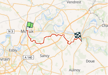
Trail Walking of 36 km to be discovered at Ile-de-France, Seine-et-Marne, Meaux. This trail is proposed by chessyca.

Description

Une troisième étape décidée à la dernière minute et plutôt décevante dans l'ensemble par rapport aux précédentes

Les points forts :
- Jouarre que nous avions visité sur l'étape 2
- Meaux que nous avons visité à plusieurs reprises
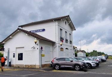
- Montceaux les Meaux avec son église et son très beau château
Les points faibles
- un parcours très éprouvant ( 37 km et presque 550 mètres de dénivelés) avec plus de 20 km sur l'aqueduc de la Dhuys. Cette année le chemin de l'aqueduc est extrêmement humide ce qui rend le chemin plus difficile, très glissant et monotone. Le parcours récupéré comptait également quelques erreurs qui ont rallongé notre parcours de près de 4 km.
Une seule chance au final : épargnés par la pluie !

Elevation profile

Photos

Positioning

Country:
France
Region :
Ile-de-France
Department/Province :
Seine-et-Marne
Municipality :
Meaux
Location:
Unknown
Start:(UTM)
490739 ; 5422693 (31U) N.

Trails nearby

Trail Walking Crégy-lès-Meaux - SM_CREGY-LES-MEAUX_8Km - Photo
Walking
GR77LP

Walking

Medium
(8)
Crégy-lès-Meaux, Ile-de-France, Seine-et-Marne, France
7.8 km | 9.2 km-effort
2h 5min
Yes
Trail Mountain bike Nanteuil-lès-Meaux - tite boucle Nanteuil par l'eau - Photo
Mountain bike
benbass77

Mountain bike

Easy
(1)
Nanteuil-lès-Meaux, Ile-de-France, Seine-et-Marne, France
23 km | 26 km-effort
1h 48min
Yes
Trail Walking Meaux - SM_MEAUX_LePâtis_8km. - Photo
Walking
GR77LP

Walking

Easy
(3)
Meaux, Ile-de-France, Seine-et-Marne, France
7.9 km | 8.4 km-effort
1h 54min
Yes
Trail Walking Meaux - Canal autour de Meaux - Photo
Walking
Emmanuel1971

Walking

Easy
(1)
Meaux, Ile-de-France, Seine-et-Marne, France
11.4 km | 12.3 km-effort
2h 51min
Yes
Trail Walking Chambry - Chambry Grand Parcours - Photo
Walking
CC.RIDER

Walking

Easy
(2)
Chambry, Ile-de-France, Seine-et-Marne, France
18.3 km | 20 km-effort
4h 29min
Yes
Trail Walking Meaux - Le tour du Grand Paris via le GR1 - Etape 10 Meaux Mortcerf - Photo
Walking
chessyca

Walking

Difficult
Meaux, Ile-de-France, Seine-et-Marne, France
34 km | 40 km-effort
6h 35min
No
Trail Walking Meaux - MEAUX BOUCLE 19 KM - Photo
Walking
gemau77

Walking

Very easy
(1)
Meaux, Ile-de-France, Seine-et-Marne, France
19.1 km | 22 km-effort
4h 47min
Yes
Trail Running Meaux - Meaux Condorcet - Photo
Running
32mike32

Running

Very easy
(2)
Meaux, Ile-de-France, Seine-et-Marne, France
11.5 km | 12.5 km-effort
1h 0min
Yes
Trail Running  - Trail court - Chauconin 77124 - Photo
Running
nrosier1

Running

Difficult
(1)
, Ile-de-France, Seine-et-Marne, France
21 km | 26 km-effort
2h 1min
Yes


Close
My subscriptions