Trail Cycle Roz-sur-Couesnon - sptw mont st michel - Photo
© OpenStreetMap contributors
Length
Length
49 km
Max alt
Max alt
14 m
Uphill gradient
Uphill gradient
151 m
Km-Effort
Km-Effort  
51 km
Min alt
Min alt
1 m
Downhill gradient
Downhill gradient
149 m
Boucle
Boucle
No
Creation date :
2024-06-13 07:54:52.855
Updated on :
2024-06-18 17:23:27.611

(0 Reviews)

Cycle
Cycle
0m
Difficulty : Very easy

Scan this QR Code to open this trail in the SityTrail application

FREE GPS app for hiking

Logo SityTrail SityTrail

IGN / Geographical institutes

Download SityTrail from the App Store Download SityTrail from Google Play

Logo SityTrail SityTrail World

The world is yours!

Download SityTrail from the App Store Download SityTrail from Google Play Download SityTrail on Huawei AppGallery

About

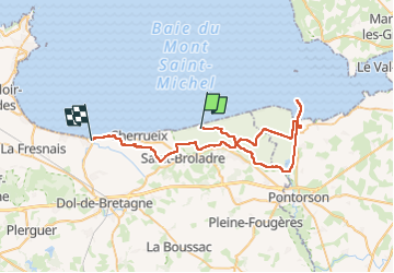
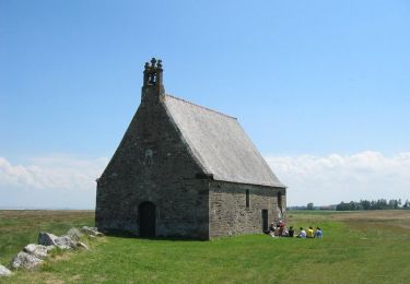
Trail Cycle of 49 km to be discovered at Brittany, Ille-et-Vilaine, Roz-sur-Couesnon. This trail is proposed by Claire TKINT.

Description

belle balade
il y a un cafe sympa à Le-Vivier-sur-Mer sur la place de leglise

Elevation profile

Positioning

Country:
France
Region :
Brittany
Department/Province :
Ille-et-Vilaine
Municipality :
Roz-sur-Couesnon
Location:
Unknown
Start:(UTM)
600777 ; 5385187 (30U) N.

Trails nearby

Trail On foot Saint-Georges-de-Gréhaigne - Circuit du Petit Bois & de la Grève - Photo
On foot
GUIDE+

On foot

Easy
Saint-Georges-de-Gréhaigne, Brittany, Ille-et-Vilaine, France
9.1 km | 10.4 km-effort
2h 21min
Yes
Trail On foot Saint-Broladre - Les deux vallées - Photo
On foot
GUIDE+

On foot

Easy
(1)
Saint-Broladre, Brittany, Ille-et-Vilaine, France
8.7 km | 10.3 km-effort
2h 20min
Yes
Trail On foot Saint-Marcan - Le télégraphe de Chappe - Photo
On foot
GUIDE+

On foot

Easy
Saint-Marcan, Brittany, Ille-et-Vilaine, France
7.6 km | 9 km-effort
2h 3min
Yes
Trail On foot Roz-sur-Couesnon - Les Polders - Photo
On foot
GUIDE+

On foot

Easy
Roz-sur-Couesnon, Brittany, Ille-et-Vilaine, France
12 km | 14 km-effort
3h 10min
Yes
Trail On foot Roz-sur-Couesnon - Les Belvédères du Mont-Saint-Michel - Photo
On foot
GUIDE+

On foot

Easy
Roz-sur-Couesnon, Brittany, Ille-et-Vilaine, France
8.7 km | 10.9 km-effort
2h 28min
No
Trail Walking Saint-Marcan - GR_34_AB_02_St-Marcan_Hirel_20230319 - Photo
Walking
patrickdanilo

Walking

Very easy
Saint-Marcan, Brittany, Ille-et-Vilaine, France
22 km | 25 km-effort
5h 7min
No
Trail On foot Saint-Broladre - La chapelle Sainte-Anne - Photo
On foot
GUIDE+

On foot

Easy
Saint-Broladre, Brittany, Ille-et-Vilaine, France
13.4 km | 13.9 km-effort
3h 9min
Yes
Trail Equestrian Saint-Broladre - Voie Verte de la Baie du Mont-Saint-Michel - Photo
Equestrian
tracegps

Equestrian

Medium
Saint-Broladre, Brittany, Ille-et-Vilaine, France
14 km | 14.6 km-effort
2h 0min
No
Trail Equestrian Roz-sur-Couesnon - Le Balcon de la Baie - Roz-sur-Couesnon  - Photo
Equestrian
tracegps

Equestrian

Medium
Roz-sur-Couesnon, Brittany, Ille-et-Vilaine, France
13.7 km | 15.6 km-effort
2h 0min
No


Close
My subscriptions