Konopiste SityTrail > Trails > Outdoor > Czech Republic > Central Bohemia > Unknown > Benešov SityTrail > Trails > Outdoor > Czech Republic > Central Bohemia > Unknown > Benešov Konopiste jcm17 User 3D © OpenStreetMap contributors Length 1.9 km Max alt 383 m Uphill gradient 46 m Km-Effort 2.6 km Min alt 346 m Downhill gradient 46 m Boucle Yes Creation date : 2024-06-11 13:21:02.198 Updated on : 2024-06-12 15:34:11.882 (0 Reviews) Walking 2h26 Difficulty : Easy FREE GPS app for hiking SityTrail IGN / Geographical institutes SityTrail World The world is yours! About 
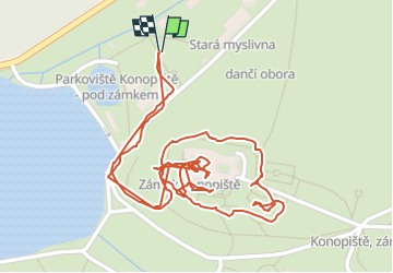
Trail Walking of 1.9 km to be discovered at Central Bohemia, Unknown, Benešov. This trail is proposed by jcm17. Legends | More details (PDF) Elevation profile Legends > 15% 15% - 10% 10% - 5% flat 5% - 10% 10% - 15% 15% - 30% > 30% Positioning Country: Czech Republic Region : Central Bohemia Department/Province : Unknown Municipality : Benešov Location: Unknown Start:(Dec) 49.7810622 / 14.6555671 Start:(UTM) 475204 ; 5514346 (33U) N. Comments Please log in to post a review or rate the element Trails nearby GUIDE+ [Č] Konopiště, okružní trasa On foot Easy Benešov, Central Bohemia, Unknown, Czech Republic 5.3 km | 6.9 km-effort 1h 34min Yes GUIDE+ [Ž] Benešov - Týnec n. Sázavou On foot Easy Benešov, Central Bohemia, Unknown, Czech Republic 13.5 km | 16.6 km-effort 3h 46min No