Trail Walking Benešov - Konopiste  - Photo
 jcm17
jcm17

User

© OpenStreetMap contributors
Length
Length
1.9 km
Max alt
Max alt
383 m
Uphill gradient
Uphill gradient
46 m
Km-Effort
Km-Effort  
2.6 km
Min alt
Min alt
346 m
Downhill gradient
Downhill gradient
46 m
Boucle
Boucle
Yes
Creation date :
2024-06-11 13:21:02.198
Updated on :
2024-06-12 15:34:11.882

(0 Reviews)

Walking
Walking
2h26
Difficulty : Easy

Scan this QR Code to open this trail in the SityTrail application

FREE GPS app for hiking

Logo SityTrail SityTrail

IGN / Geographical institutes

Download SityTrail from the App Store Download SityTrail from Google Play

Logo SityTrail SityTrail World

The world is yours!

Download SityTrail from the App Store Download SityTrail from Google Play Download SityTrail on Huawei AppGallery

About

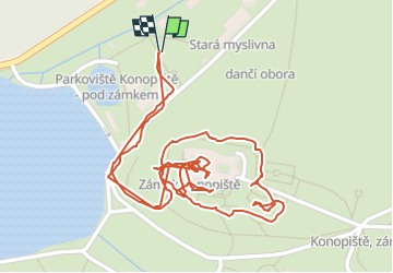
Trail Walking of 1.9 km to be discovered at Central Bohemia, Unknown, Benešov. This trail is proposed by jcm17.

Elevation profile

Positioning

Country:
Czech Republic
Region :
Central Bohemia
Department/Province :
Unknown
Municipality :
Benešov
Location:
Unknown
Start:(UTM)
475204 ; 5514346 (33U) N.

Trails nearby

Trail Cycle Týnec nad Sázavou - Týnec nad Sázavou - Tábor - Photo
Cycle
karawatsj

Cycle

Difficult
Týnec nad Sázavou, Central Bohemia, Unknown, Czech Republic
71 km | 87 km-effort
5h 9min
No
Trail Car Slapy - Konopiste - Photo
Car
jcm17

Car

Very easy
Slapy, Central Bohemia, Unknown, Czech Republic
38 km | 46 km-effort
45min
No
Trail Motorboat Hradištko - Moldau  - Photo
Motorboat
jcm17

Motorboat

Very easy
Hradištko, Central Bohemia, Unknown, Czech Republic
10.7 km | 14.1 km-effort
1h 34min
No


Close
My subscriptions