Trail Walking Rosais - 22/06/24 AÇORES SAO JORGE ROSAIS 52 - Photo

22/06/24 AÇORES SAO JORGE ROSAIS 52

© OpenStreetMap contributors
Length
Length
10.3 km
Max alt
Max alt
412 m
Uphill gradient
Uphill gradient
616 m
Km-Effort
Km-Effort  
18.5 km
Min alt
Min alt
6 m
Downhill gradient
Downhill gradient
616 m
Boucle
Boucle
Yes
Creation date :
2024-06-12 13:08:45.881
Updated on :
2024-06-12 13:13:39.068

(1 Reviews)

Walking
Walking
4h12
Difficulty : Difficult

Scan this QR Code to open this trail in the SityTrail application

FREE GPS app for hiking

Logo SityTrail SityTrail

IGN / Geographical institutes

Download SityTrail from the App Store Download SityTrail from Google Play

Logo SityTrail SityTrail World

The world is yours!

Download SityTrail from the App Store Download SityTrail from Google Play Download SityTrail on Huawei AppGallery

About

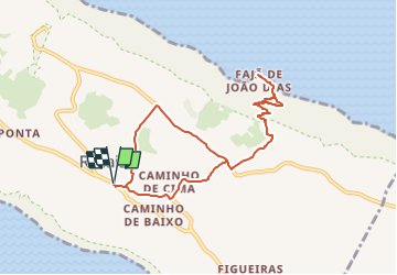
Trail Walking of 10.3 km to be discovered at Azores, Unknown, Rosais. This trail is proposed by Lucienfilippi.

Description

ROZAIS
CAMINHO DE CIMA
OUTERO DE LOURAL
FAJA DE JOAO. DIAS
VERS PICO DAS URZES
REDESCE,DRE ROSAIS

Elevation profile

Positioning

Country:
Portugal
Region :
Azores
Department/Province :
Unknown
Municipality :
Rosais
Location:
Unknown
Start:(UTM)
391325 ; 4286221 (26S) N.

Comments

Please log in to post a review or rate the element


Trails nearby

Trail Walking Rosais - saojorgevarianteretourvelas - Photo
Walking
Lucienfilippi

Walking

Difficult
Rosais, Azores, Unknown, Portugal
9.2 km | 12.4 km-effort
2h 48min
No
Trail Walking  - São Jorge-Ponta dos Rosais 30-06-2018 - Photo
Walking
fredetpascale

Walking

Easy
(1)
, Azores, , Portugal
13.1 km | 17.6 km-effort
3h 0min
Yes


Close
My subscriptions