Trail Walking Santa Luzia - 24/06/24 AÇORES /PICO 35 AUTOUR SANTA MARIA - Photo

24/06/24 AÇORES /PICO 35 AUTOUR SANTA MARIA

© OpenStreetMap contributors
Length
Length
16.2 km
Max alt
Max alt
249 m
Uphill gradient
Uphill gradient
391 m
Km-Effort
Km-Effort  
21 km
Min alt
Min alt
3 m
Downhill gradient
Downhill gradient
393 m
Boucle
Boucle
Yes
Creation date :
2024-06-12 12:37:57.257
Updated on :
2024-06-12 12:49:15.237

(0 Reviews)

Walking
Walking
4h51
Difficulty : Very difficult

Scan this QR Code to open this trail in the SityTrail application

FREE GPS app for hiking

Logo SityTrail SityTrail

IGN / Geographical institutes

Download SityTrail from the App Store Download SityTrail from Google Play

Logo SityTrail SityTrail World

The world is yours!

Download SityTrail from the App Store Download SityTrail from Google Play Download SityTrail on Huawei AppGallery

About

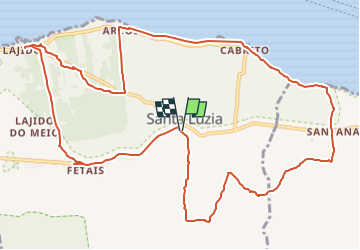
Trail Walking of 16.2 km to be discovered at Azores, Unknown, Santa Luzia. This trail is proposed by Lucienfilippi.

Description

SANTA LUZIA CIMETIERE
CAMINO ALTO RUA DE CIMA
SANTANA
BAHIA DO
CABRITO
ERMIDA DE SAO MATEUS
ARCOS
DESCENDRE G PUIS LAJIDO
FETAIS
SANTA LUZIA

Elevation profile

Positioning

Country:
Portugal
Region :
Azores
Department/Province :
Unknown
Municipality :
Santa Luzia
Location:
Unknown
Start:(UTM)
378035 ; 4267343 (26S) N.

Trails nearby

Trail On foot  - Santana – Lajido - Photo
On foot
GUIDE+

On foot

Easy
, Azores, , Portugal
8.1 km | 10.4 km-effort
2h 22min
No
Trail On foot Santa Luzia - Caminhos de Santa Luzia - Photo
On foot
GUIDE+

On foot

Easy
Santa Luzia, Azores, Unknown, Portugal
9.5 km | 12.9 km-effort
2h 56min
No


Close
My subscriptions