![](/images/other/stat-length.png)
![Trail Walking Laroque-des-Albères - La vallée heureuse retour par le lotisement - Photo](https://media.geolcdn.com/t/1900/400/ed98f66a-fede-45a2-a33c-c5755783d354.jpg&format=pjpeg&maxdim=2)
La vallée heureuse retour par le lotisement
nandaf
User
![Length](/images/other/stat-length.png)
![Max alt](https://static1.geolcdn.com/siteimages/upload/files/1508320355ic_sort_altitude_max_24dp.png)
![Uphill gradient](https://static1.geolcdn.com/siteimages/upload/files/1508320355ic_sort_den_pos_24dp.png)
![Km-Effort](/images/other/stat-length.png)
![Min alt](https://static1.geolcdn.com/siteimages/upload/files/1508320355ic_sort_altitude_min_24dp.png)
![Downhill gradient](https://static1.geolcdn.com/siteimages/upload/files/1508320355ic_sort_den_neg_24dp.png)
![Boucle](https://static1.geolcdn.com/siteimages/upload/files/16400158638029165_repeat_loop_refresh_sync_direction_icon.png)
![Walking](https://static1.geolcdn.com/sitytour/trail-icons/101.png)
3h41
Difficulty : Difficult
![Scan this QR Code to open this trail in the SityTrail application](https://capi.geolives.com/qq0zvz2zws4bq2lad0pu/sitytour/trails/4087485/qr.png?size=200)
FREE GPS app for hiking
About
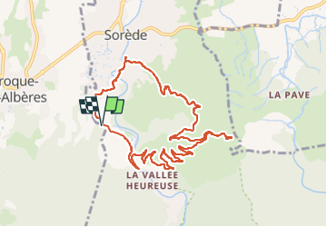
Trail Walking of 11.2 km to be discovered at Occitania, Pyrénées-Orientales, Laroque-des-Albères. This trail is proposed by nandaf.
Description
Sorède, la Vallée des tortues, montée jusqu'à la chapelle Notre-Dame du Château d'Ultrera retour avec une petite partie finale par un lotissement de Sorède.
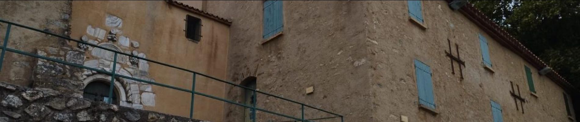
Notre-Dame du Château (en catalan: Mare de Deu del Castell) est un ancien ermitage et sanctuaire dédié à la Vierge Marie situé dans le massif des Albères, à proximité du château d'Ultrera dans la commune de Sorède. L'ermitage est toujours un lieu de pèlerinage auquel les habitants de la région avoisinante restent très attachés.
Positioning
Comments
Trails nearby
![Trail Walking Laroque-des-Albères - Laroque-des-Albères, petit tour des mas - Photo](https://media.geolcdn.com/t/375/260/a38763d0-1e12-4df0-8310-6577414297bd.jpg&format=jpg&maxdim=2)
![Walking Walking](https://static1.geolcdn.com/sitytour/trail-icons/101.png)
Walking
![](/images/other/stat-length.png)
![](https://static1.geolcdn.com/siteimages/upload/files/16400158638029165_repeat_loop_refresh_sync_direction_icon.png)
![Trail Walking Laroque-des-Albères - 66 LAROQUE DES ALBERES (maison) SOREDE, par pistes DFCI AL12 et 19, mas del Ca et mas Manere, Itin.16 - Photo](https://media.geolcdn.com/t/375/260/ext.jpg?maxdim=2&url=https%3A%2F%2Fservices.sitytrail.com%2FGeolivesWS%2FDownloadMedia.ashx%3FTrailID%3D585179%26Media%3D20160616145650.jpg)
![Walking Walking](https://static1.geolcdn.com/sitytour/trail-icons/101.png)
Walking
![](/images/other/stat-length.png)
![](https://static1.geolcdn.com/siteimages/upload/files/16400158638029165_repeat_loop_refresh_sync_direction_icon.png)
![Trail Walking Laroque-des-Albères - 66 SOREDE, LAROQUE DES ALBERES, chemins des Mas - Photo](https://media.geolcdn.com/t/375/260/ext.jpg?maxdim=2&url=https%3A%2F%2Fservices.sitytrail.com%2FGeolivesWS%2FDownloadMedia.ashx%3FTrailID%3D534699%26Media%3D20160303171633.jpg)
![Walking Walking](https://static1.geolcdn.com/sitytour/trail-icons/101.png)
Walking
![](/images/other/stat-length.png)
![](https://static1.geolcdn.com/siteimages/upload/files/16400158638029165_repeat_loop_refresh_sync_direction_icon.png)
![Trail Walking Saint-André - 66 SAINT-ANDRE - SOREDE - chapelle Saint Ferreol de la Pava - Photo](https://media.geolcdn.com/t/375/260/ext.jpg?maxdim=2&url=https%3A%2F%2Fservices.sitytrail.com%2FGeolivesWS%2FDownloadMedia.ashx%3FTrailID%3D455673%26Media%3D20150807175253.jpg)
![Walking Walking](https://static1.geolcdn.com/sitytour/trail-icons/101.png)
Walking
![](/images/other/stat-length.png)
![](https://static1.geolcdn.com/siteimages/upload/files/16400158638029165_repeat_loop_refresh_sync_direction_icon.png)
![Trail Walking L'Albère - SAINT-JEAN-D'ALBERE 66 - PUIG de Sant Christau par le coll de Sant Joan - Photo](https://media.geolcdn.com/t/375/260/ext.jpg?maxdim=2&url=https%3A%2F%2Fservices.sitytrail.com%2FGeolivesWS%2FDownloadMedia.ashx%3FTrailID%3D452444%26Media%3D20150731170134.jpg)
![Walking Walking](https://static1.geolcdn.com/sitytour/trail-icons/101.png)
Walking
![](/images/other/stat-length.png)
![](https://static1.geolcdn.com/siteimages/upload/files/16400158638029165_repeat_loop_refresh_sync_direction_icon.png)
![Trail Walking Palau-del-Vidre - PALAU-DEL-VIDRE 66 - Boucle de Villeclare - promenade dans les vergers et cultures maraîchères - Photo](https://media.geolcdn.com/t/375/260/ext.jpg?maxdim=2&url=https%3A%2F%2Fservices.sitytrail.com%2FGeolivesWS%2FDownloadMedia.ashx%3FTrailID%3D426910%26Media%3D20150528155048.jpg)
![Walking Walking](https://static1.geolcdn.com/sitytour/trail-icons/101.png)
Walking
![](/images/other/stat-length.png)
![](https://static1.geolcdn.com/siteimages/upload/files/16400158638029165_repeat_loop_refresh_sync_direction_icon.png)
![Trail Walking Sorède - Utrera Font Miracles T - Photo](https://media.geolcdn.com/t/375/260/ext.jpg?maxdim=2&url=https%3A%2F%2Fservices.sitytrail.com%2FGeolivesWS%2FDownloadMedia.ashx%3FTrailID%3D419352%26Media%3Dfix__20150510145313.jpg)
![Walking Walking](https://static1.geolcdn.com/sitytour/trail-icons/101.png)
Walking
![](/images/other/stat-length.png)
![](https://static1.geolcdn.com/siteimages/upload/files/16400158638029165_repeat_loop_refresh_sync_direction_icon.png)
![Trail Walking Sorède - 577. 11km sorede roc des medes - Photo](https://media.geolcdn.com/t/375/260/61f4e75a-7c25-4df1-b192-fc8eca3c7acc.jpg&format=jpg&maxdim=2)
![Walking Walking](https://static1.geolcdn.com/sitytour/trail-icons/101.png)
Walking
![](/images/other/stat-length.png)
![](https://static1.geolcdn.com/siteimages/upload/files/16400158638029165_repeat_loop_refresh_sync_direction_icon.png)
![Trail Walking Laroque-des-Albères - Col-Ullat Pic-aureille_Terrain - Photo](https://media.geolcdn.com/t/375/260/ext.jpg?maxdim=2&url=https%3A%2F%2Fservices.sitytrail.com%2FGeolivesWS%2FDownloadMedia.ashx%3FTrailID%3D221622%26Media%3Dfix__20130916174240.jpg)
![Walking Walking](https://static1.geolcdn.com/sitytour/trail-icons/101.png)
Walking
![](/images/other/stat-length.png)
![](https://static1.geolcdn.com/siteimages/upload/files/16400158638029165_repeat_loop_refresh_sync_direction_icon.png)