Trail Walking Saint-Dyé-sur-Loire - saint dyé - Photo
© OpenStreetMap contributors
Length
Length
2.4 km
Max alt
Max alt
91 m
Uphill gradient
Uphill gradient
24 m
Km-Effort
Km-Effort  
2.7 km
Min alt
Min alt
73 m
Downhill gradient
Downhill gradient
22 m
Boucle
Boucle
Yes
Creation date :
2024-06-11 08:32:18.481
Updated on :
2024-06-11 10:44:22.949

(0 Reviews)

Walking
Walking
2h10
Difficulty : Easy

Scan this QR Code to open this trail in the SityTrail application

FREE GPS app for hiking

Logo SityTrail SityTrail

IGN / Geographical institutes

Download SityTrail from the App Store Download SityTrail from Google Play

Logo SityTrail SityTrail World

The world is yours!

Download SityTrail from the App Store Download SityTrail from Google Play Download SityTrail on Huawei AppGallery

About

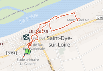
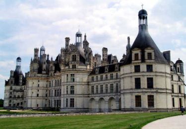
Trail Walking of 2.4 km to be discovered at Centre-Loire Valley, Loir-et-Cher, Saint-Dyé-sur-Loire. This trail is proposed by nicole.reine@wanadoo.fr.

Description

départ maison des étangs

Elevation profile

Photos

Positioning

Country:
France
Region :
Centre-Loire Valley
Department/Province :
Loir-et-Cher
Municipality :
Saint-Dyé-sur-Loire
Location:
Unknown
Start:(UTM)
386352 ; 5278953 (31T) N.

Trails nearby

Trail Road bike Muides-sur-Loire - Itinéraire 12 - Au fil de Loire - Photo
Road bike
verpoorten

Road bike

Very difficult
(1)
Muides-sur-Loire, Centre-Loire Valley, Loir-et-Cher, France
39 km | 43 km-effort
2h 36min
Yes
Trail Walking Chambord - chambord chateau  - Photo
Walking
nicole.reine@wanadoo.fr

Walking

Easy
Chambord, Centre-Loire Valley, Loir-et-Cher, France
3.8 km | 4.5 km-effort
3h 34min
Yes
Trail Walking Chambord - Parc de Chambord et ses postes d'observation  - Photo
Walking
guydu41

Walking

Easy
Chambord, Centre-Loire Valley, Loir-et-Cher, France
20 km | 22 km-effort
5h 3min
Yes
Trail On foot Chambord - petite marche 6 km dans chambord - Photo
On foot
Billonmichel

On foot

Easy
(1)
Chambord, Centre-Loire Valley, Loir-et-Cher, France
6.1 km | 6.9 km-effort
1h 33min
Yes
Trail Hybrid bike Muides-sur-Loire - Muides Blois Chambord  - Photo
Hybrid bike
karani27

Hybrid bike

Medium
Muides-sur-Loire, Centre-Loire Valley, Loir-et-Cher, France
51 km | 57 km-effort
4h 41min
No
Trail Mountain bike Chambord - chambord-cheverny - Photo
Mountain bike
Dp35

Mountain bike

Easy
(1)
Chambord, Centre-Loire Valley, Loir-et-Cher, France
23 km | 25 km-effort
1h 41min
No
Trail Walking Chambord - chambord - Photo
Walking
pistou

Walking

Easy
Chambord, Centre-Loire Valley, Loir-et-Cher, France
3.8 km | 4.4 km-effort
4h 7min
Yes
Trail Walking Chambord - Chambord-Rond point François 1° - Photo
Walking
lemuid

Walking

Very easy
Chambord, Centre-Loire Valley, Loir-et-Cher, France
8.7 km | 9.7 km-effort
1h 55min
Yes
Trail Cycle Chambord - De Beaugency à Chambord - Photo
Cycle
tracegps

Cycle

Easy
Chambord, Centre-Loire Valley, Loir-et-Cher, France
28 km | 31 km-effort
1h 49min
No


Close
My subscriptions