Trail Walking Unknown - Penestanan et Sayan - Photo

Penestanan et Sayan

 lhomme.ph
lhomme.ph

User GUIDE

© OpenStreetMap contributors
Length
Length
10.8 km
Max alt
Max alt
271 m
Uphill gradient
Uphill gradient
209 m
Km-Effort
Km-Effort  
13.6 km
Min alt
Min alt
178 m
Downhill gradient
Downhill gradient
209 m
Boucle
Boucle
Yes
Creation date :
2018-04-28 00:00:00.0
Updated on :
2018-04-28 00:00:00.0

(0 Reviews)

Walking
Walking
2h51
Difficulty : Easy

Scan this QR Code to open this trail in the SityTrail application

FREE GPS app for hiking

Logo SityTrail SityTrail

IGN / Geographical institutes

Download SityTrail from the App Store Download SityTrail from Google Play

Logo SityTrail SityTrail World

The world is yours!

Download SityTrail from the App Store Download SityTrail from Google Play Download SityTrail on Huawei AppGallery

About

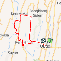
Trail Walking of 10.8 km to be discovered at Bali, Ubud. This trail is proposed by lhomme.ph.

Description

Penestanan et Sayan (7km, 3h, marche en contrebas des hotels de luxe dans la vallée de la Sungai Ayung) : tout de suite à l'ouest du pont de Campuan, le Jl Raya Penestanan très pentue traverse le ravin boisé de Sungai Blangsuh jusqu'au village d'artistes de Penestanan; à l'ouest du village, prendre une petite route vers le nord qui décrit une courbe autour de Sayan (vue magnifique sur la vallée de la Sungai Ayung); le meilleur point de départ jusqu'à la rivière est situé au nord de l'hôtel Sayan Terrace; en traversant les chemins qui partent vers le nord (Ayung à main gauche), on grimpe des pentes abruptes, traverse des rizières, des canaux d'irrigation et des tunnels); au point d'arrivée des excursions en rafting, un sentier raide rejoint la route principale de Kedewatan qui ramène à Ubud. Possibilité de traverser la rivière et de grimper au village de Tegalkuning.

Elevation profile

Positioning

Country:
Indonesia
Region :
Bali
Department/Province :
Ubud
Municipality :
Unknown
Location:
Unknown
Start:(UTM)
309034 ; 9059101 (50L) S.

Trails nearby

Trail Walking  - Monkey Forest et Penestanan (projet) - Photo
Walking
GUIDE
lhomme.ph

Walking

Easy
, Bali, Ubud, Indonesia
8 km | 9.4 km-effort
2h 1min
Yes
Trail Walking  - Autour de la crête de Campuhan - Photo
Walking
GUIDE
lhomme.ph

Walking

Easy
(1)
, Bali, Ubud, Indonesia
7.6 km | 9.8 km-effort
2h 0min
Yes
Trail Walking  - Rizières Ubud - Photo
Walking
GUIDE
lhomme.ph

Walking

Medium
, Bali, Ubud, Indonesia
21 km | 26 km-effort
5h 0min
No
Trail Other activity  - Petit tour dans les rizières d'Ubud  - Photo
Other activity
GUIDE
lhomme.ph

Other activity

Very easy
, Bali, Ubud, Indonesia
5.8 km | 6.6 km-effort
1h 34min
Yes
Trail Walking  - Ubud (Petit tour Es - Photo
Walking
GUIDE
lhomme.ph

Walking

Very easy
, Bali, Ubud, Indonesia
5.3 km | 5.9 km-effort
1h 17min
Yes


Close
My subscriptions