Trail On foot Sainte-Agnès - Col des BANQUETTES MT SIRICOCCA - Photo
 Renefrt
Renefrt

User

© OpenStreetMap contributors
Length
Length
7.4 km
Max alt
Max alt
1046 m
Uphill gradient
Uphill gradient
416 m
Km-Effort
Km-Effort  
13 km
Min alt
Min alt
667 m
Downhill gradient
Downhill gradient
413 m
Boucle
Boucle
Yes
Creation date :
2024-06-10 14:44:31.667
Updated on :
2024-06-10 14:48:53.157

(0 Reviews)

On foot
On foot
2h56
Difficulty : Easy

Scan this QR Code to open this trail in the SityTrail application

FREE GPS app for hiking

Logo SityTrail SityTrail

IGN / Geographical institutes

Download SityTrail from the App Store Download SityTrail from Google Play

Logo SityTrail SityTrail World

The world is yours!

Download SityTrail from the App Store Download SityTrail from Google Play Download SityTrail on Huawei AppGallery

About

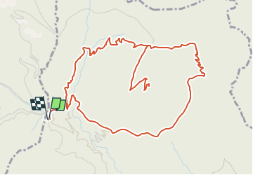
Trail On foot of 7.4 km to be discovered at Provence-Alpes-Côte d'Azur, Maritime Alps, Sainte-Agnès. This trail is proposed by Renefrt.

Description

UNE TRÈS  JOLIE VUE DU FORT, FAIRE ATTENTION DANS LA DESCENTE.

PEUT SE FAIRE EGALEMENT DE STE AGNES

Elevation profile

Positioning

Country:
France
Region :
Provence-Alpes-Côte d'Azur
Department/Province :
Maritime Alps
Municipality :
Sainte-Agnès
Location:
Unknown
Start:(UTM)
375099 ; 4852340 (32T) N.

Trails nearby

Trail Walking Castellar - Mont Carpano en boucle - Photo
Walking
boboazur

Walking

Medium
(1)
Castellar, Provence-Alpes-Côte d'Azur, Maritime Alps, France
8.1 km | 14.4 km-effort
3h 18min
Yes
Trail Walking Castellar - Castellar Gramondo Bocca Bassa Col St Bernard Monti réel - Photo
Walking
GUIDE
jouans

Walking

Very difficult
Castellar, Provence-Alpes-Côte d'Azur, Maritime Alps, France
18.1 km | 36 km-effort
8h 17min
Yes
Trail On foot Peille - Cime de Baudon - Photo
On foot
GUIDE+

On foot

Easy
Peille, Provence-Alpes-Côte d'Azur, Maritime Alps, France
7 km | 14.7 km-effort
3h 20min
Yes
Trail Walking Gorbio - Gorbio-Circuit des Cabanelles 31-10-2016 - Photo
Walking
GUIDE
fredetpascale

Walking

Medium
(1)
Gorbio, Provence-Alpes-Côte d'Azur, Maritime Alps, France
10.8 km | 21 km-effort
3h 51min
Yes
Trail Walking Peille - Cime de Baudon - Photo
Walking
maxcagaze

Walking

Medium
(1)
Peille, Provence-Alpes-Côte d'Azur, Maritime Alps, France
7.8 km | 15.7 km-effort
4h 15min
Yes
Trail Walking Castellar - mont carpano au départ de Castellar - Photo
Walking
56jj

Walking

Medium
Castellar, Provence-Alpes-Côte d'Azur, Maritime Alps, France
7.7 km | 13.9 km-effort
5h 14min
Yes
Trail Walking Castellar - Castellane - roc d'Ormea - Photo
Walking
patsure

Walking

Medium
Castellar, Provence-Alpes-Côte d'Azur, Maritime Alps, France
9.7 km | 20 km-effort
3h 26min
No
Trail Walking Castillon - Castillon : Mt Ours - Photo
Walking
ETMU5496

Walking

Medium
Castillon, Provence-Alpes-Côte d'Azur, Maritime Alps, France
16.7 km | 29 km-effort
4h 22min
Yes
Trail Walking Castellar - gam - Photo
Walking
MauriceJardret

Walking

Very difficult
Castellar, Provence-Alpes-Côte d'Azur, Maritime Alps, France
14.5 km | 28 km-effort
4h 47min
Yes


Close
My subscriptions