Trail Walking Chambord - Parc de Chambord et ses postes d'observation  - Photo

Parc de Chambord et ses postes d'observation

 guydu41
guydu41

User

© OpenStreetMap contributors
Length
Length
20 km
Max alt
Max alt
109 m
Uphill gradient
Uphill gradient
148 m
Km-Effort
Km-Effort  
22 km
Min alt
Min alt
70 m
Downhill gradient
Downhill gradient
149 m
Boucle
Boucle
Yes
Creation date :
2024-06-07 08:46:50.417
Updated on :
2024-06-08 13:34:03.739

(0 Reviews)

Walking
Walking
5h03
Difficulty : Easy

Scan this QR Code to open this trail in the SityTrail application

FREE GPS app for hiking

Logo SityTrail SityTrail

IGN / Geographical institutes

Download SityTrail from the App Store Download SityTrail from Google Play

Logo SityTrail SityTrail World

The world is yours!

Download SityTrail from the App Store Download SityTrail from Google Play Download SityTrail on Huawei AppGallery

About

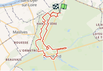
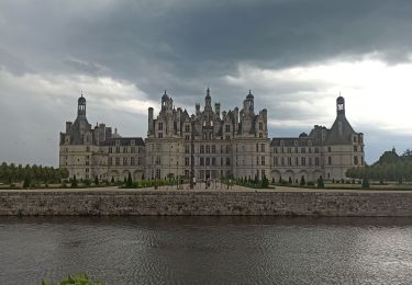
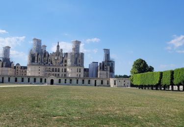
Trail Walking of 20 km to be discovered at Centre-Loire Valley, Loir-et-Cher, Chambord. This trail is proposed by guydu41.

Description

Ce circuit au départ du parking de la Gabillière sur la route François 1er (D112) dans le parc de Chambord permet d'accéder à une dizaine de postes d'observation de la faune sauvage.
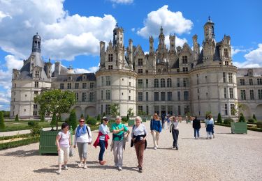
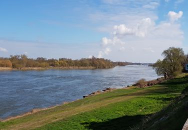
Il fait le tour du magnifique Château de Chambord, de longer les douves et une partie du Cosson.
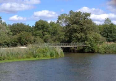
Il emprunte des allées, de très beaux chemins boisés et aussi de magnifiques sentiers tortueux dans la forêt.
Le contournement de l'étang au Nord-Ouest de la Hannetière ne peut se faire que si son niveau d'eau est bas.

Elevation profile

Photos

66 photos in total. Please click on a photo to see them all in the gallery.

Positioning

Country:
France
Region :
Centre-Loire Valley
Department/Province :
Loir-et-Cher
Municipality :
Chambord
Location:
Unknown
Start:(UTM)
389508 ; 5278144 (31T) N.

Trails nearby

Trail Road bike Muides-sur-Loire - Itinéraire 12 - Au fil de Loire - Photo
Road bike
verpoorten

Road bike

Very difficult
(1)
Muides-sur-Loire, Centre-Loire Valley, Loir-et-Cher, France
39 km | 43 km-effort
2h 36min
Yes
Trail Walking Chambord - chambord chateau  - Photo
Walking
nicole.reine@wanadoo.fr

Walking

Easy
Chambord, Centre-Loire Valley, Loir-et-Cher, France
3.8 km | 4.5 km-effort
3h 34min
Yes
Trail On foot Chambord - petite marche 6 km dans chambord - Photo
On foot
Billonmichel

On foot

Easy
(1)
Chambord, Centre-Loire Valley, Loir-et-Cher, France
6.1 km | 6.9 km-effort
1h 33min
Yes
Trail Hybrid bike Muides-sur-Loire - Muides Blois Chambord  - Photo
Hybrid bike
karani27

Hybrid bike

Medium
Muides-sur-Loire, Centre-Loire Valley, Loir-et-Cher, France
51 km | 57 km-effort
4h 41min
No
Trail Bicycle tourism Saint-Laurent-Nouan - Bois Renard - Blois et retour.  - Photo
Bicycle tourism
pffrench

Bicycle tourism

Medium
Saint-Laurent-Nouan, Centre-Loire Valley, Loir-et-Cher, France
54 km | 59 km-effort
6h 51min
Yes
Trail Mountain bike Chambord - chambord-cheverny - Photo
Mountain bike
Dp35

Mountain bike

Easy
(1)
Chambord, Centre-Loire Valley, Loir-et-Cher, France
23 km | 25 km-effort
1h 41min
No
Trail Walking Saint-Dyé-sur-Loire - saint dyé - Photo
Walking
nicole.reine@wanadoo.fr

Walking

Easy
Saint-Dyé-sur-Loire, Centre-Loire Valley, Loir-et-Cher, France
2.4 km | 2.7 km-effort
2h 10min
Yes
Trail Walking Chambord - chambord - Photo
Walking
pistou

Walking

Easy
Chambord, Centre-Loire Valley, Loir-et-Cher, France
3.8 km | 4.4 km-effort
4h 7min
Yes
Trail Walking Chambord - Chambord-Rond point François 1° - Photo
Walking
lemuid

Walking

Very easy
Chambord, Centre-Loire Valley, Loir-et-Cher, France
8.7 km | 9.7 km-effort
1h 55min
Yes


Close
My subscriptions