Trail Walking Arvieux - Furfande Chantal vers col des Lauzes - Photo

Furfande Chantal vers col des Lauzes

 damlou
damlou

User

© OpenStreetMap contributors
Length
Length
14.7 km
Max alt
Max alt
2293 m
Uphill gradient
Uphill gradient
713 m
Km-Effort
Km-Effort  
24 km
Min alt
Min alt
1886 m
Downhill gradient
Downhill gradient
714 m
Boucle
Boucle
Yes
Creation date :
2024-06-05 07:42:12.636
Updated on :
2024-06-05 15:15:50.614

(0 Reviews)

Walking
Walking
4h55
Difficulty : Medium

Scan this QR Code to open this trail in the SityTrail application

FREE GPS app for hiking

Logo SityTrail SityTrail

IGN / Geographical institutes

Download SityTrail from the App Store Download SityTrail from Google Play

Logo SityTrail SityTrail World

The world is yours!

Download SityTrail from the App Store Download SityTrail from Google Play Download SityTrail on Huawei AppGallery

About

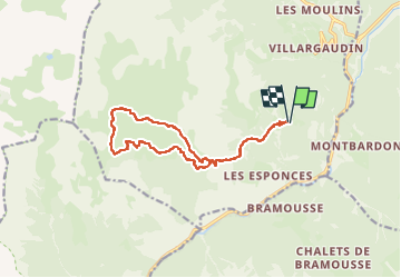
Trail Walking of 14.7 km to be discovered at Provence-Alpes-Côte d'Azur, Hautes-Alpes, Arvieux. This trail is proposed by damlou.

Description

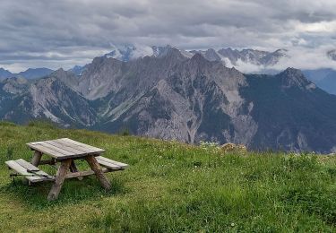
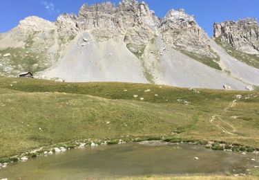
Depart parking du Queyron col des Lauze
Refuge de Furfande descendre vers lac de La Valette puis lac du Lauzon

Elevation profile

Positioning

Country:
France
Region :
Provence-Alpes-Côte d'Azur
Department/Province :
Hautes-Alpes
Municipality :
Arvieux
Location:
Unknown
Start:(UTM)
321770 ; 4955261 (32T) N.

Comments

Please log in to post a review or rate the element


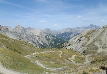
Pour Furfande départ 8H30 soit du parking de Queyron ou du col de Furfande et descendre vers refuge si on dort au refuge on peut faire montée au refuge repas de midi là ensuite le lac du Lauzet retour refuge Dormir le lendemain retour


Trails nearby

Trail Mountain bike Château-Ville-Vieille - Tour du Queyras - Photo
Mountain bike
tracegps

Mountain bike

Very difficult
(1)
Château-Ville-Vieille, Provence-Alpes-Côte d'Azur, Hautes-Alpes, France
32 km | 50 km-effort
3h 0min
Yes
Trail Walking Arvieux - les alpages de Furfande - Photo
Walking
GUIDE
amiral13

Walking

Easy
Arvieux, Provence-Alpes-Côte d'Azur, Hautes-Alpes, France
17 km | 29 km-effort
6h 57min
Yes
Trail Snowshoes Arvieux - Arvieux- Col de Furfande - Photo
Snowshoes
meunier.ph.

Snowshoes

Easy
Arvieux, Provence-Alpes-Côte d'Azur, Hautes-Alpes, France
12.9 km | 26 km-effort
4h 6min
Yes
Trail Walking Arvieux - arvieux en boucle par furfande ( col et chalets) - Photo
Walking
tchoua

Walking

Easy
Arvieux, Provence-Alpes-Côte d'Azur, Hautes-Alpes, France
21 km | 38 km-effort
4h 40min
Yes
Trail Walking Château-Ville-Vieille - 05-pointe-du-Rasis-13km-760m-aout21 - Photo
Walking
SyMA

Walking

Difficult
Château-Ville-Vieille, Provence-Alpes-Côte d'Azur, Hautes-Alpes, France
13.2 km | 23 km-effort
5h 32min
Yes
Trail Walking Arvieux - Furfande - Photo
Walking
CAUBERTGENEVIEVE

Walking

Medium
Arvieux, Provence-Alpes-Côte d'Azur, Hautes-Alpes, France
12.6 km | 22 km-effort
7h 14min
No
Trail Snowshoes Arvieux - villardgaudin - Photo
Snowshoes
doumeherve

Snowshoes

Very easy
Arvieux, Provence-Alpes-Côte d'Azur, Hautes-Alpes, France
4.7 km | 7.8 km-effort
1h 37min
No
Trail Walking Arvieux - Com de Fontouse - Photo
Walking
Sorriaux

Walking

Difficult
Arvieux, Provence-Alpes-Côte d'Azur, Hautes-Alpes, France
8.6 km | 18.6 km-effort
3h 26min
Yes
Trail Walking Arvieux - 05 Le tour de la dent du Ratier Queyras - Photo
Walking
silvestreclaudine

Walking

Difficult
Arvieux, Provence-Alpes-Côte d'Azur, Hautes-Alpes, France
19.5 km | 34 km-effort
9h 23min
Yes


Close
My subscriptions