![](/images/other/stat-length.png)
![Trail Walking Belz - Séjour 2024 GR 34 j4 Pont Lorois - Lorient - Photo](https://media.geolcdn.com/t/1900/400/ext.pjpeg?maxdim=2&url=https%3A%2F%2Fstatic1.geolcdn.com%2Fsiteimages%2Fupload%2Ffiles%2F1553511878bg_sport_marche.png)
Séjour 2024 GR 34 j4 Pont Lorois - Lorient
chessyca
User
![Length](/images/other/stat-length.png)
Length
23 km
![Max alt](https://static1.geolcdn.com/siteimages/upload/files/1508320355ic_sort_altitude_max_24dp.png)
Max alt
20 m
![Uphill gradient](https://static1.geolcdn.com/siteimages/upload/files/1508320355ic_sort_den_pos_24dp.png)
Uphill gradient
140 m
![Km-Effort](/images/other/stat-length.png)
Km-Effort
25 km
![Min alt](https://static1.geolcdn.com/siteimages/upload/files/1508320355ic_sort_altitude_min_24dp.png)
Min alt
-2 m
![Downhill gradient](https://static1.geolcdn.com/siteimages/upload/files/1508320355ic_sort_den_neg_24dp.png)
Downhill gradient
140 m
![Boucle](https://static1.geolcdn.com/siteimages/upload/files/16400158638029165_repeat_loop_refresh_sync_direction_icon.png)
Boucle
No
Creation date :
2024-06-04 07:05:31.099
Updated on :
2024-06-09 09:38:34.67
![Walking](https://static1.geolcdn.com/sitytour/trail-icons/101.png)
5h05
Difficulty : Easy
![Scan this QR Code to open this trail in the SityTrail application](https://capi.geolives.com/qq0zvz2zws4bq2lad0pu/sitytour/trails/4079436/qr.png?size=200)
FREE GPS app for hiking
About
Trail Walking of 23 km to be discovered at Brittany, Morbihan, Belz. This trail is proposed by chessyca.
Description
Quatrième journée du séjour
Départ en bus de Penthièvre à Pont Lorois
Arrivée à Lorient et bus jusqu'à l'auberge de Jeunesse
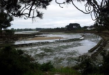
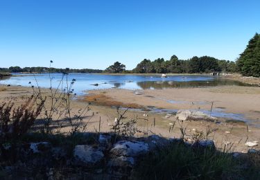
Pas de difficultés sur le terrain
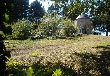
de splendides paysages
Positioning
Country:
France
Region :
Brittany
Department/Province :
Morbihan
Municipality :
Belz
Location:
Unknown
Start:(Dec)
Start:(UTM)
485178 ; 5280299 (30T) N.
Comments
Trails nearby
![Trail Walking Plouhinec - PR_56_Plouhinec_AA_01_Circuit1b_La-Ria-Par-Les-Pinedes_20200712 - Photo](https://media.geolcdn.com/t/375/260/ext.jpg?maxdim=2&url=https%3A%2F%2Fmedia.geolcdn.com%2Ff%2F1d672734-99d3-43b8-9472-2acec23bab09.jpg)
![Walking Walking](https://static1.geolcdn.com/sitytour/trail-icons/101.png)
PR_56_Plouhinec_AA_01_Circuit1b_La-Ria-Par-Les-Pinedes_20200712
Walking
Very easy
(2)
Plouhinec,
Brittany,
Morbihan,
France
![](/images/other/stat-length.png)
9.7 km | 10.6 km-effort
2h 14min
![](https://static1.geolcdn.com/siteimages/upload/files/16400158638029165_repeat_loop_refresh_sync_direction_icon.png)
Yes
![Trail Walking Plouhinec - Rivière d'Etel - Photo](https://media.geolcdn.com/t/375/260/ext.jpg?maxdim=2&url=https%3A%2F%2Fservices.sitytrail.com%2FGeolivesWS%2FDownloadMedia.ashx%3FTrailID%3D691090%26Media%3Dfix__20170128155839.jpg)
![Walking Walking](https://static1.geolcdn.com/sitytour/trail-icons/101.png)
Rivière d'Etel
Walking
Medium
(1)
Plouhinec,
Brittany,
Morbihan,
France
![](/images/other/stat-length.png)
15.4 km | 16.7 km-effort
3h 42min
![](https://static1.geolcdn.com/siteimages/upload/files/16400158638029165_repeat_loop_refresh_sync_direction_icon.png)
Yes
![Trail Nordic walking Plouhinec - D'Etel au Pont Laurois par les deux côtés de la Ria - Photo](https://media.geolcdn.com/t/375/260/ext.jpg?maxdim=2&url=https%3A%2F%2Fservices.sitytrail.com%2FGeolivesWS%2FDownloadMedia.ashx%3FTrailID%3D323717%26Media%3Dfix__20140713124707.jpg)
![Nordic walking Nordic walking](https://static1.geolcdn.com/sitytour/trail-icons/102.png)
D'Etel au Pont Laurois par les deux côtés de la Ria
Nordic walking
Easy
(2)
Plouhinec,
Brittany,
Morbihan,
France
![](/images/other/stat-length.png)
13.3 km | 14.5 km-effort
2h 25min
![](https://static1.geolcdn.com/siteimages/upload/files/16400158638029165_repeat_loop_refresh_sync_direction_icon.png)
No
![Trail Walking Étel - bignac - Photo](https://media.geolcdn.com/t/375/260/ext.jpg?maxdim=2&url=https%3A%2F%2Fservices.sitytrail.com%2FGeolivesWS%2FDownloadMedia.ashx%3FTrailID%3D153357%26Media%3D20120913152815.jpeg)
![Walking Walking](https://static1.geolcdn.com/sitytour/trail-icons/101.png)
![Trail Nordic walking Belz - Bignac 05-11-17 . - Photo](https://media.geolcdn.com/t/375/260/ext.jpg?maxdim=2&url=https%3A%2F%2Fservices.sitytrail.com%2FGeolivesWS%2FDownloadMedia.ashx%3FTrailID%3D857287%26Media%3Dfix__20171104144738.jpg)
![Nordic walking Nordic walking](https://static1.geolcdn.com/sitytour/trail-icons/102.png)
Bignac 05-11-17 .
Nordic walking
Very easy
(1)
Belz,
Brittany,
Morbihan,
France
![](/images/other/stat-length.png)
9.8 km | 10.7 km-effort
1h 53min
![](https://static1.geolcdn.com/siteimages/upload/files/16400158638029165_repeat_loop_refresh_sync_direction_icon.png)
Yes
![Trail Walking Belz - L 'Île de Saint Cado (07- 06-15 - Photo](https://media.geolcdn.com/t/375/260/ext.jpg?maxdim=2&url=https%3A%2F%2Fservices.sitytrail.com%2FGeolivesWS%2FDownloadMedia.ashx%3FTrailID%3D430884%26Media%3Dfix__20150607180503.jpg)
![Walking Walking](https://static1.geolcdn.com/sitytour/trail-icons/101.png)
L 'Île de Saint Cado (07- 06-15
Walking
Very easy
(1)
Belz,
Brittany,
Morbihan,
France
![](/images/other/stat-length.png)
2.2 km | 2.4 km-effort
55min
![](https://static1.geolcdn.com/siteimages/upload/files/16400158638029165_repeat_loop_refresh_sync_direction_icon.png)
Yes
![Trail Walking Plouhinec - tour ria etel bretagne - Photo](https://media.geolcdn.com/t/375/260/ext.jpg?maxdim=2&url=https%3A%2F%2Fservices.sitytrail.com%2FGeolivesWS%2FDownloadMedia.ashx%3FTrailID%3D329248%26Media%3Dfix__20140730144510.jpg)
![Walking Walking](https://static1.geolcdn.com/sitytour/trail-icons/101.png)
tour ria etel bretagne
Walking
Easy
(1)
Plouhinec,
Brittany,
Morbihan,
France
![](/images/other/stat-length.png)
15.3 km | 16.8 km-effort
3h 57min
![](https://static1.geolcdn.com/siteimages/upload/files/16400158638029165_repeat_loop_refresh_sync_direction_icon.png)
Yes
![Trail On foot Belz - Etre douar ar mor - Photo](https://media.geolcdn.com/t/375/260/ext.jpg?maxdim=2&url=https%3A%2F%2Fmedia.geolcdn.com%2Ff%2Fe888e374-1c52-424c-bf66-49a872f27ec5.jpeg)
![On foot On foot](https://static1.geolcdn.com/sitytour/trail-icons/100.png)
![Trail On foot Belz - Pointe de Larmor - Photo](https://media.geolcdn.com/t/375/260/ext.jpg?maxdim=2&url=https%3A%2F%2Fmedia.geolcdn.com%2Ff%2F40fdb565-6f0c-4011-b858-188c7966310e.jpeg)
![On foot On foot](https://static1.geolcdn.com/sitytour/trail-icons/100.png)