![](/images/other/stat-length.png)
![Trail Walking Saint-Quentin-en-Tourmont - Marquenterre - Photo](https://media.geolcdn.com/t/1900/400/71e341ba-1bd4-4c57-bcbb-36c5452ff049.jpg&format=pjpeg&maxdim=2)
Marquenterre
Greg813
User
![Length](/images/other/stat-length.png)
![Max alt](https://static1.geolcdn.com/siteimages/upload/files/1508320355ic_sort_altitude_max_24dp.png)
![Uphill gradient](https://static1.geolcdn.com/siteimages/upload/files/1508320355ic_sort_den_pos_24dp.png)
![Km-Effort](/images/other/stat-length.png)
![Min alt](https://static1.geolcdn.com/siteimages/upload/files/1508320355ic_sort_altitude_min_24dp.png)
![Downhill gradient](https://static1.geolcdn.com/siteimages/upload/files/1508320355ic_sort_den_neg_24dp.png)
![Boucle](https://static1.geolcdn.com/siteimages/upload/files/16400158638029165_repeat_loop_refresh_sync_direction_icon.png)
![Walking](https://static1.geolcdn.com/sitytour/trail-icons/101.png)
3h43
Difficulty : Medium
![Scan this QR Code to open this trail in the SityTrail application](https://capi.geolives.com/qq0zvz2zws4bq2lad0pu/sitytour/trails/4077597/qr.png?size=200)
FREE GPS app for hiking
About
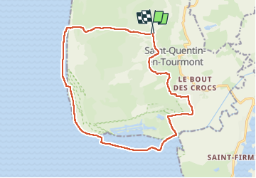
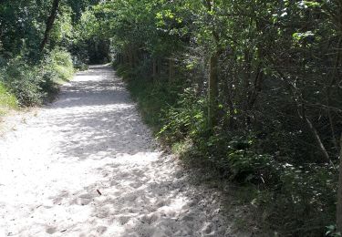
Trail Walking of 16.7 km to be discovered at Hauts-de-France, Somme, Saint-Quentin-en-Tourmont. This trail is proposed by Greg813.
Description
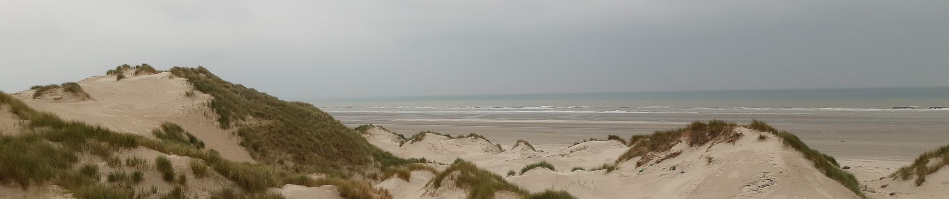
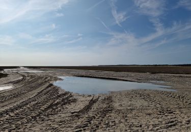
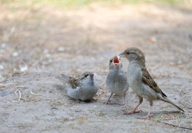
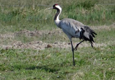
Randonnée avec Mettons le Monde en Marche dans la réserve naturelle de la baie de Somme. Depuis St Quentin en Tourmont, tour du parc Ornithologique par les places en doublant la pointe de St Quentin.
Pour plus de photos, voir le site de l'association :
https://mmm-rando.org/week-end-en-baie-de-somme-2024/
Positioning
Comments
Trails nearby
![Trail Walking Le Crotoy - CDT80-3 - Photo](https://media.geolcdn.com/t/375/260/cef91e86-689f-4bd7-8591-33e387b29cb5.jpg&format=jpg&maxdim=2)
![Walking Walking](https://static1.geolcdn.com/sitytour/trail-icons/101.png)
Walking
![](/images/other/stat-length.png)
![](https://static1.geolcdn.com/siteimages/upload/files/16400158638029165_repeat_loop_refresh_sync_direction_icon.png)
![Trail Walking Quend - Le Colombier - Photo](https://media.geolcdn.com/t/375/260/ext.jpg?maxdim=2&url=https%3A%2F%2Fservices.sitytrail.com%2FGeolivesWS%2FDownloadMedia.ashx%3FTrailID%3D108606%26Media%3D1514_1.jpg)
![Walking Walking](https://static1.geolcdn.com/sitytour/trail-icons/101.png)
Walking
![](/images/other/stat-length.png)
![](https://static1.geolcdn.com/siteimages/upload/files/16400158638029165_repeat_loop_refresh_sync_direction_icon.png)
![Trail Walking Saint-Quentin-en-Tourmont - Les crocs - Saint Quentin en Tourmont - Photo](https://media.geolcdn.com/t/375/260/ext.jpg?maxdim=2&url=https%3A%2F%2Fservices.sitytrail.com%2FGeolivesWS%2FDownloadMedia.ashx%3FTrailID%3D108604%26Media%3D1512_1.jpg)
![Walking Walking](https://static1.geolcdn.com/sitytour/trail-icons/101.png)
Walking
![](/images/other/stat-length.png)
![](https://static1.geolcdn.com/siteimages/upload/files/16400158638029165_repeat_loop_refresh_sync_direction_icon.png)
![Trail Equestrian Le Crotoy - de la Maye vers marquenterre - Photo](https://media.geolcdn.com/t/375/260/ext.jpg?maxdim=2&url=https%3A%2F%2Fstatic1.geolcdn.com%2Fsiteimages%2Fupload%2Ffiles%2F1524743154cheval.jpg)
![Equestrian Equestrian](https://static1.geolcdn.com/sitytour/trail-icons/300.png)
Equestrian
![](/images/other/stat-length.png)
![](https://static1.geolcdn.com/siteimages/upload/files/16400158638029165_repeat_loop_refresh_sync_direction_icon.png)
![Trail Walking Le Crotoy - La Maille - Pointe de St Quentin - Photo](https://media.geolcdn.com/t/375/260/3398be8c-4fd8-4935-b428-3382873060ae.jpg&format=jpg&maxdim=2)
![Walking Walking](https://static1.geolcdn.com/sitytour/trail-icons/101.png)
Walking
![](/images/other/stat-length.png)
![](https://static1.geolcdn.com/siteimages/upload/files/16400158638029165_repeat_loop_refresh_sync_direction_icon.png)
![Trail Walking Quend - dixk-mônchaux - Photo](https://media.geolcdn.com/t/375/260/0c33e945-d50d-4b4a-bef0-ad25dd476496.jpg&format=jpg&maxdim=2)
![Walking Walking](https://static1.geolcdn.com/sitytour/trail-icons/101.png)
Walking
![](/images/other/stat-length.png)
![](https://static1.geolcdn.com/siteimages/upload/files/16400158638029165_repeat_loop_refresh_sync_direction_icon.png)
![Trail On foot Quend - Le Colombier - Photo](https://media.geolcdn.com/t/375/260/716ce54f-89a0-4335-b6e0-2d178a29836d.jpeg&format=jpg&maxdim=2)
![On foot On foot](https://static1.geolcdn.com/sitytour/trail-icons/100.png)
On foot
![](/images/other/stat-length.png)
![](https://static1.geolcdn.com/siteimages/upload/files/16400158638029165_repeat_loop_refresh_sync_direction_icon.png)
![Trail On foot - Les Crocs - Photo](https://media.geolcdn.com/t/375/260/edc33d6b-f7f4-4df4-988f-507b11ec46ba.jpeg&format=jpg&maxdim=2)
![On foot On foot](https://static1.geolcdn.com/sitytour/trail-icons/100.png)
![Trail Walking Saint-Quentin-en-Tourmont - chemin du littoral - Photo](https://media.geolcdn.com/t/375/260/f76ad346-696d-4bdc-b9e1-ffa0c4856a8a.jpg&format=jpg&maxdim=2)
![Walking Walking](https://static1.geolcdn.com/sitytour/trail-icons/101.png)
Walking
![](/images/other/stat-length.png)
![](https://static1.geolcdn.com/siteimages/upload/files/16400158638029165_repeat_loop_refresh_sync_direction_icon.png)