


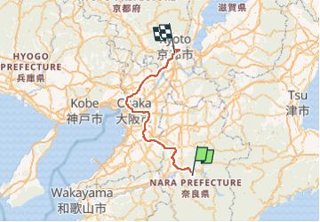
20240601 Mont Koya Kyoto

Childebert
User

Length
148 km

Max alt
432 m

Uphill gradient
2238 m
Km-Effort
179 km

Min alt
-10 m

Downhill gradient
2616 m
Boucle
No
Creation date :
2024-05-31 21:56:07.535
Updated on :
2024-06-10 19:24:05.996
12h55
Difficulty : Very easy

FREE GPS app for hiking
 SityTrail
IGN / Geographical institutes
SityTrail World
The world is yours!
About
Trail Car of 148 km to be discovered at Nara Prefecture, Yoshino County. This trail is proposed by Childebert.
Positioning
Country:
Japan
Region :
Nara Prefecture
Department/Province :
Yoshino County
Municipality :
Unknown
Location:
Unknown
Start:(Dec)
Start:(UTM)
579440 ; 3802463 (53S) N.
Comments
Trails nearby