![](/images/other/stat-length.png)
![Trail Walking Mazet-Saint-Voy - Le Mazet HL Tour du Lizieux J2 - Photo](https://media.geolcdn.com/t/1900/400/ext.pjpeg?maxdim=2&url=https%3A%2F%2Fstatic1.geolcdn.com%2Fsiteimages%2Fupload%2Ffiles%2F1553511878bg_sport_marche.png)
Le Mazet HL Tour du Lizieux J2
pascalmilpas
User
![Length](/images/other/stat-length.png)
Length
15.4 km
![Max alt](https://static1.geolcdn.com/siteimages/upload/files/1508320355ic_sort_altitude_max_24dp.png)
Max alt
1375 m
![Uphill gradient](https://static1.geolcdn.com/siteimages/upload/files/1508320355ic_sort_den_pos_24dp.png)
Uphill gradient
428 m
![Km-Effort](/images/other/stat-length.png)
Km-Effort
21 km
![Min alt](https://static1.geolcdn.com/siteimages/upload/files/1508320355ic_sort_altitude_min_24dp.png)
Min alt
1012 m
![Downhill gradient](https://static1.geolcdn.com/siteimages/upload/files/1508320355ic_sort_den_neg_24dp.png)
Downhill gradient
432 m
![Boucle](https://static1.geolcdn.com/siteimages/upload/files/16400158638029165_repeat_loop_refresh_sync_direction_icon.png)
Boucle
Yes
Creation date :
2024-05-29 07:42:35.428
Updated on :
2024-05-29 13:57:08.407
![Walking](https://static1.geolcdn.com/sitytour/trail-icons/101.png)
5h43
Difficulty : Very difficult
![Scan this QR Code to open this trail in the SityTrail application](https://capi.geolives.com/qq0zvz2zws4bq2lad0pu/sitytour/trails/4072471/qr.png?size=200)
FREE GPS app for hiking
About
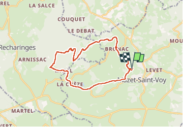
Trail Walking of 15.4 km to be discovered at Auvergne-Rhône-Alpes, Haute-Loire, Mazet-Saint-Voy. This trail is proposed by pascalmilpas.
Description
Boucle de 15 kms au départ de l'exceptionnelle Chapelle Saint Voy au dessus du Mazet
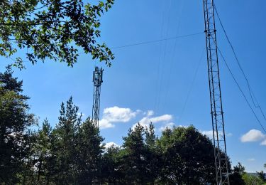
Montée au Lizieux tres raide par face NE
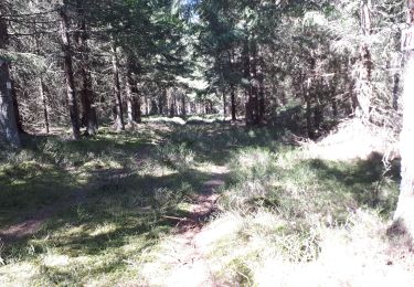
Descente un peu plus facile par face SO
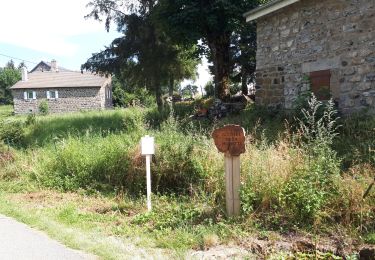
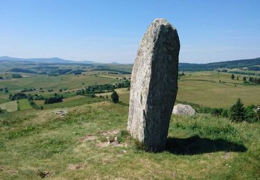
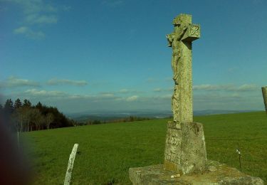
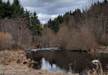
Beaux chemins, forêt splendide
Positioning
Country:
France
Region :
Auvergne-Rhône-Alpes
Department/Province :
Haute-Loire
Municipality :
Mazet-Saint-Voy
Location:
Unknown
Start:(Dec)
Start:(UTM)
597502 ; 4989520 (31T) N.
Comments
Trails nearby
![Trail Walking Araules - Suc de Lizieux - Photo](https://media.geolcdn.com/t/375/260/3244aa12-5792-460e-ba20-16eff7ba3ca0.jpg&format=jpg&maxdim=2)
![Walking Walking](https://static1.geolcdn.com/sitytour/trail-icons/101.png)
Suc de Lizieux
Walking
Medium
Araules,
Auvergne-Rhône-Alpes,
Haute-Loire,
France
![](/images/other/stat-length.png)
4.6 km | 6.9 km-effort
1h 38min
![](https://static1.geolcdn.com/siteimages/upload/files/16400158638029165_repeat_loop_refresh_sync_direction_icon.png)
Yes
![Trail Walking Mazet-Saint-Voy - Volamont - Photo](https://media.geolcdn.com/t/375/260/c9dbf91a-f16e-4cab-801b-bd884d3b8b0a.jpg&format=jpg&maxdim=2)
![Walking Walking](https://static1.geolcdn.com/sitytour/trail-icons/101.png)
Volamont
Walking
Easy
Mazet-Saint-Voy,
Auvergne-Rhône-Alpes,
Haute-Loire,
France
![](/images/other/stat-length.png)
5 km | 6.7 km-effort
2h 32min
![](https://static1.geolcdn.com/siteimages/upload/files/16400158638029165_repeat_loop_refresh_sync_direction_icon.png)
Yes
![Trail Walking Araules - le sentier de Bonas - Photo](https://media.geolcdn.com/t/375/260/d68ee2be-74cb-4667-89e5-08e6c8a501e3.jpg&format=jpg&maxdim=2)
![Walking Walking](https://static1.geolcdn.com/sitytour/trail-icons/101.png)
le sentier de Bonas
Walking
Easy
Araules,
Auvergne-Rhône-Alpes,
Haute-Loire,
France
![](/images/other/stat-length.png)
6.8 km | 9.5 km-effort
1h 57min
![](https://static1.geolcdn.com/siteimages/upload/files/16400158638029165_repeat_loop_refresh_sync_direction_icon.png)
Yes
![Trail Walking Les Vastres - Villelonge-Les Vastres PR - Photo](https://media.geolcdn.com/t/375/260/5deb3f17-9dda-4268-91eb-d498c615cc80.jpg&format=jpg&maxdim=2)
![Walking Walking](https://static1.geolcdn.com/sitytour/trail-icons/101.png)
Villelonge-Les Vastres PR
Walking
Very easy
Les Vastres,
Auvergne-Rhône-Alpes,
Haute-Loire,
France
![](/images/other/stat-length.png)
14 km | 17 km-effort
3h 47min
![](https://static1.geolcdn.com/siteimages/upload/files/16400158638029165_repeat_loop_refresh_sync_direction_icon.png)
No
![Trail Walking Mazet-Saint-Voy - Baignade du moulin de Boyer - Photo](https://media.geolcdn.com/t/375/260/af6c2a74-4729-449d-ba55-588030a8ac48.jpg&format=jpg&maxdim=2)
![Walking Walking](https://static1.geolcdn.com/sitytour/trail-icons/101.png)
Baignade du moulin de Boyer
Walking
Very easy
Mazet-Saint-Voy,
Auvergne-Rhône-Alpes,
Haute-Loire,
France
![](/images/other/stat-length.png)
3.7 km | 4.8 km-effort
1h 29min
![](https://static1.geolcdn.com/siteimages/upload/files/16400158638029165_repeat_loop_refresh_sync_direction_icon.png)
Yes
![Trail Walking Araules - Tence-170620 - PicLisieux - Photo](https://media.geolcdn.com/t/375/260/ext.jpg?maxdim=2&url=https%3A%2F%2Fservices.sitytrail.com%2FGeolivesWS%2FDownloadMedia.ashx%3FTrailID%3D776323%26Media%3D23dfef1f-c30a-4947-bbbf-c2a486ff054a.jpg)
![Walking Walking](https://static1.geolcdn.com/sitytour/trail-icons/101.png)
Tence-170620 - PicLisieux
Walking
Medium
Araules,
Auvergne-Rhône-Alpes,
Haute-Loire,
France
![](/images/other/stat-length.png)
5.2 km | 7.6 km-effort
1h 50min
![](https://static1.geolcdn.com/siteimages/upload/files/16400158638029165_repeat_loop_refresh_sync_direction_icon.png)
Yes
![Trail Mountain bike Saint-Jeures - Les champs de St Jeures - Photo](https://media.geolcdn.com/t/375/260/ext.jpg?maxdim=2&url=https%3A%2F%2Fservices.sitytrail.com%2FGeolivesWS%2FDownloadMedia.ashx%3FTrailID%3D129689%26Media%3D13222_4.jpg)
![Mountain bike Mountain bike](https://static1.geolcdn.com/sitytour/trail-icons/202.png)
Les champs de St Jeures
Mountain bike
Easy
Saint-Jeures,
Auvergne-Rhône-Alpes,
Haute-Loire,
France
![](/images/other/stat-length.png)
11.6 km | 15.2 km-effort
1h 30min
![](https://static1.geolcdn.com/siteimages/upload/files/16400158638029165_repeat_loop_refresh_sync_direction_icon.png)
Yes
![Trail Walking Saint-Jeures - Les champs de St Jeures - Photo](https://media.geolcdn.com/t/375/260/ext.jpg?maxdim=2&url=https%3A%2F%2Fservices.sitytrail.com%2FGeolivesWS%2FDownloadMedia.ashx%3FTrailID%3D129688%26Media%3D13222_4.jpg)
![Walking Walking](https://static1.geolcdn.com/sitytour/trail-icons/101.png)
Les champs de St Jeures
Walking
Easy
Saint-Jeures,
Auvergne-Rhône-Alpes,
Haute-Loire,
France
![](/images/other/stat-length.png)
11.6 km | 15.2 km-effort
2h 30min
![](https://static1.geolcdn.com/siteimages/upload/files/16400158638029165_repeat_loop_refresh_sync_direction_icon.png)
Yes
![Trail Walking Mazet-Saint-Voy - Salettes et Mazalibran - Photo](https://media.geolcdn.com/t/375/260/42cfbe72-4434-4356-970f-aa668c703a3b.jpg&format=jpg&maxdim=2)
![Walking Walking](https://static1.geolcdn.com/sitytour/trail-icons/101.png)
Salettes et Mazalibran
Walking
Medium
Mazet-Saint-Voy,
Auvergne-Rhône-Alpes,
Haute-Loire,
France
![](/images/other/stat-length.png)
8.8 km | 11.9 km-effort
2h 30min
![](https://static1.geolcdn.com/siteimages/upload/files/16400158638029165_repeat_loop_refresh_sync_direction_icon.png)
Yes