Trail On foot Aubergenville - sitytrail-grp-la-seine-impressionniste-parcours-complet - Photo

sitytrail-grp-la-seine-impressionniste-parcours-complet

 chessyca
chessyca

User GUIDE

© OpenStreetMap contributors
Length
Length
37 km
Max alt
Max alt
150 m
Uphill gradient
Uphill gradient
446 m
Km-Effort
Km-Effort  
43 km
Min alt
Min alt
14 m
Downhill gradient
Downhill gradient
454 m
Boucle
Boucle
No
Creation date :
2024-05-25 17:43:33.058
Updated on :
2024-05-25 17:54:42.999

(0 Reviews)

On foot
On foot
9h42
Difficulty : Very difficult

Scan this QR Code to open this trail in the SityTrail application

FREE GPS app for hiking

Logo SityTrail SityTrail

IGN / Geographical institutes

Download SityTrail from the App Store Download SityTrail from Google Play

Logo SityTrail SityTrail World

The world is yours!

Download SityTrail from the App Store Download SityTrail from Google Play Download SityTrail on Huawei AppGallery

About

Trail On foot of 37 km to be discovered at Ile-de-France, Yvelines, Aubergenville. This trail is proposed by chessyca.

Description

Etape 1 Chatou Sartrouville
Etape 2 Sartrouville Conflans Ste Honorine
Etape 3  Conflans Ste Honorine Triels
Etape 4  Triels  Aubergenville
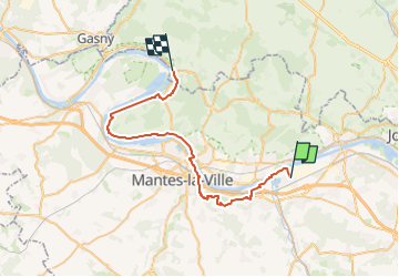
Etape 5 Aubergenville Mantes
Etape 6 Mantes Vétheuil
Etape 7  Vétheuil Bonnières
Etape 8 Bonnières Vernon

Elevation profile

Points of interest

Point of interest Sartrouville - GRP La Seine impressionniste, Etape 2 : Sartrouville - Conflans-Sainte-Honorine
 - Photo
chessyca
Point of interest Conflans-Sainte-Honorine - GRP La Seine impressionniste, Etape 3: Conflans-Sainte-Honorine - Triel
 - Photo
chessyca
CONFLANS-SAINTE-HONORINE 
Point of interest Triel-sur-Seine - GRP La Seine impressionniste, Etape 4 : Triel - Aubergenville
 - Photo
chessyca
Point of interest Aubergenville - GRP La Seine impressionniste, Etape 5 : Aubergenville - Mantes
 - Photo
chessyca
Point of interest Mantes-la-Jolie - GRP La Seine impressionniste, Etape 6 : Mantes - Vétheuil
 - Photo
chessyca
Point of interest Bonnières-sur-Seine - GRP La Seine impressionniste, Etape 8 : Bonnières - Vernon
 - Photo
chessyca
BONNIÈRES-SUR-SEINE 

Positioning

Country:
France
Region :
Ile-de-France
Department/Province :
Yvelines
Municipality :
Aubergenville
Location:
Unknown
Start:(Dec)
Start:(UTM)
415508 ; 5425457 (31U) N.

Trails nearby

Trail Other activity Gargenville - parcourt FIFI - Photo
Other activity
ROSA78

Other activity

Very easy
(1)
Gargenville, Ile-de-France, Yvelines, France
42 km | 46 km-effort
2h 49min
No
Trail Walking La Falaise - Aulney sur Mauldre-La Falaise - Photo
Walking
raivavae

Walking

Medium
(1)
La Falaise, Ile-de-France, Yvelines, France
12.4 km | 15.9 km-effort
Unknown
Yes
Trail Walking Épône - EPONES > MAREIL 15 KM - Photo
Walking
gemau77

Walking

Very easy
(1)
Épône, Ile-de-France, Yvelines, France
14.7 km | 18.6 km-effort
3h 55min
No
Trail Walking Aubergenville - petite balade autour du Gibouin - Photo
Walking
fredouille661

Walking

Very easy
Aubergenville, Ile-de-France, Yvelines, France
7.7 km | 8.2 km-effort
1h 45min
Yes
Trail Walking Nézel - Nezel - Aulnay sur Mauldre - Photo
Walking
fredouille661

Walking

Easy
(1)
Nézel, Ile-de-France, Yvelines, France
9.2 km | 11 km-effort
2h 23min
Yes
Trail Walking Aubergenville - Vaux les Huguenots - Photo
Walking
fredouille661

Walking

Easy
(2)
Aubergenville, Ile-de-France, Yvelines, France
7.7 km | 10.1 km-effort
2h 10min
Yes
Trail Running Les Mureaux - Trail 15K G.O-parc de la sautour - Photo
Running
rocknroy

Running

Medium
(1)
Les Mureaux, Ile-de-France, Yvelines, France
15.3 km | 18.7 km-effort
Unknown
No
Trail On foot Aubergenville - La Seine impressioniste  Etape 5 + Boucle Rosny - Mantes - Photo
On foot
GUIDE
chessyca

On foot

Very difficult
Aubergenville, Ile-de-France, Yvelines, France
39 km | 44 km-effort
10h 2min
No
Trail On foot Épône - Voyage au Bout du Monde - Photo
On foot
GUIDE+

On foot

Easy
Épône, Ile-de-France, Yvelines, France
4.3 km | 4.7 km-effort
1h 3min
Yes


Close
My subscriptions