Trail Walking Le Grand-Bornand - Aiguille verte, Col et lac de Lessy - Photo

Aiguille verte, Col et lac de Lessy

 GrouGary
GrouGary

User

© OpenStreetMap contributors
Length
Length
8.1 km
Max alt
Max alt
2008 m
Uphill gradient
Uphill gradient
615 m
Km-Effort
Km-Effort  
16.3 km
Min alt
Min alt
1419 m
Downhill gradient
Downhill gradient
612 m
Boucle
Boucle
Yes
Creation date :
2024-05-25 07:05:09.515
Updated on :
2024-05-28 13:20:55.999

(0 Reviews)

Walking
Walking
3h26
Difficulty : Medium

Scan this QR Code to open this trail in the SityTrail application

FREE GPS app for hiking

Logo SityTrail SityTrail

IGN / Geographical institutes

Download SityTrail from the App Store Download SityTrail from Google Play

Logo SityTrail SityTrail World

The world is yours!

Download SityTrail from the App Store Download SityTrail from Google Play Download SityTrail on Huawei AppGallery

About

Trail Walking of 8.1 km to be discovered at Auvergne-Rhône-Alpes, Upper Savoy, Le Grand-Bornand. This trail is proposed by GrouGary.

Description

Parcours sans difficulté, avec montée dans les alpages (vaches et chevres). Retour par le col de Lessy et descente plus raide sur sente directe.

Elevation profile

Photos

Positioning

Country:
France
Region :
Auvergne-Rhône-Alpes
Department/Province :
Upper Savoy
Municipality :
Le Grand-Bornand
Location:
Unknown
Start:(UTM)
303668 ; 5095298 (32T) N.

Trails nearby

Trail Walking Glières-Val-de-Borne - BARGY: ROCHERS DE LESCHAUX AU DEPART DE CENISE - Photo
Walking
djeepee74

Walking

Medium
(1)
Glières-Val-de-Borne, Auvergne-Rhône-Alpes, Upper Savoy, France
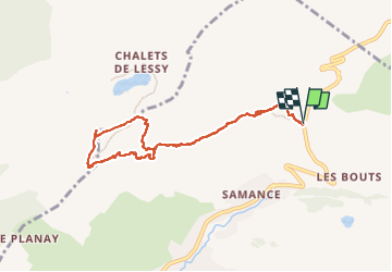
9.7 km | 15.3 km-effort
3h 30min
Yes
Trail Walking Le Grand-Bornand - Lac de Lessy depuis le Chinaillon  - Photo
Walking
lambert4zones

Walking

Medium
(1)
Le Grand-Bornand, Auvergne-Rhône-Alpes, Upper Savoy, France
13.2 km | 28 km-effort
4h 9min
Yes
Trail Walking Le Reposoir - Le Petit Bargy 2098 m, depuis Malatrait - Photo
Walking
tracegps

Walking

Medium
(1)
Le Reposoir, Auvergne-Rhône-Alpes, Upper Savoy, France
8.1 km | 18.8 km-effort
5h 0min
Yes
Trail Walking Mont-Saxonnex - Les Rochers de Leschaux, 1936m - Mont Saxonex - Photo
Walking
tracegps

Walking

Medium
(1)
Mont-Saxonnex, Auvergne-Rhône-Alpes, Upper Savoy, France
11.6 km | 20 km-effort
5h 0min
Yes
Trail Touring skiing Le Grand-Bornand - Col de Balafrasse et tout de la pointe Est du midi  - Photo
Touring skiing
GUIDE
nadd73

Touring skiing

Difficult
Le Grand-Bornand, Auvergne-Rhône-Alpes, Upper Savoy, France
14.6 km | 31 km-effort
6h 12min
Yes
Trail Touring skiing Le Grand-Bornand - PT 2595au dessus du col des Verts - Photo
Touring skiing
GUIDE
nadd73

Touring skiing

Difficult
Le Grand-Bornand, Auvergne-Rhône-Alpes, Upper Savoy, France
14.2 km | 33 km-effort
5h 54min
Yes
Trail Touring skiing Glières-Val-de-Borne - Tour du Jallouvre par le lac de Lessy  - Photo
Touring skiing
GUIDE
nadd73

Touring skiing

Difficult
Glières-Val-de-Borne, Auvergne-Rhône-Alpes, Upper Savoy, France
14.3 km | 37 km-effort
6h 39min
Yes
Trail Touring skiing Glières-Val-de-Borne - col du rasoir combe NW ET Sud - Photo
Touring skiing
GUIDE
nadd73

Touring skiing

Medium
Glières-Val-de-Borne, Auvergne-Rhône-Alpes, Upper Savoy, France
11.1 km | 29 km-effort
5h 2min
Yes
Trail Mountain bike Le Grand-Bornand - vtt-dans-la-vallee-du-bouchet - Photo
Mountain bike
GUIDE
pascalou73

Mountain bike

Very easy
Le Grand-Bornand, Auvergne-Rhône-Alpes, Upper Savoy, France
7.5 km | 10.5 km-effort
Unknown
No


Close
My subscriptions