Trail Bicycle tourism Tanlay - Tanlay - Montbard  - Photo
 ilur56
ilur56

User

© OpenStreetMap contributors
Length
Length
55 km
Max alt
Max alt
218 m
Uphill gradient
Uphill gradient
360 m
Km-Effort
Km-Effort  
60 km
Min alt
Min alt
143 m
Downhill gradient
Downhill gradient
303 m
Boucle
Boucle
No
Creation date :
2024-05-24 07:47:46.773
Updated on :
2024-06-01 14:01:19.673

(0 Reviews)

Bicycle tourism
Bicycle tourism
--
Difficulty : Easy

Scan this QR Code to open this trail in the SityTrail application

FREE GPS app for hiking

Logo SityTrail SityTrail

IGN / Geographical institutes

Download SityTrail from the App Store Download SityTrail from Google Play

Logo SityTrail SityTrail World

The world is yours!

Download SityTrail from the App Store Download SityTrail from Google Play Download SityTrail on Huawei AppGallery

About

Trail Bicycle tourism of 55 km to be discovered at Bourgogne-Franche-Comté, Yonne, Tanlay. This trail is proposed by ilur56.

Description

Troisième étape sur le Tour de Bourgogne

Elevation profile

Photos

Positioning

Country:
France
Region :
Bourgogne-Franche-Comté
Department/Province :
Yonne
Municipality :
Tanlay
Location:
Unknown
Start:(UTM)
581193 ; 5299992 (31T) N.

Trails nearby

Trail Walking Lézinnes - 20160206 Lézinnes - Photo
Walking
PascalK

Walking

Easy
Lézinnes, Bourgogne-Franche-Comté, Yonne, France
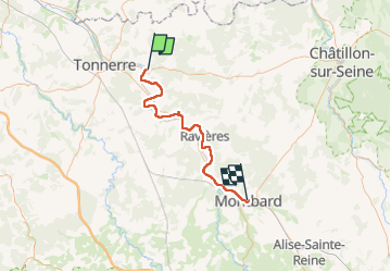
15.6 km | 18.3 km-effort
3h 29min
Yes
Trail Cycle Lézinnes - De Lézinnes à Bretigny - Photo
Cycle
destras

Cycle

Medium
Lézinnes, Bourgogne-Franche-Comté, Yonne, France
128 km | 148 km-effort
8h 27min
No
Trail Walking Molosmes - Molosmes -Epineuil - Photo
Walking
genndor

Walking

Very difficult
Molosmes, Bourgogne-Franche-Comté, Yonne, France
21 km | 26 km-effort
5h 54min
Yes
Trail Walking Tanlay - Tanlay et l’abbaye cistercienne de Quincy - Photo
Walking
Guytoumo

Walking

Easy
Tanlay, Bourgogne-Franche-Comté, Yonne, France
12.5 km | 14.9 km-effort
3h 15min
Yes


Close
My subscriptions