Trail Walking Fontainebleau - Fontainebleau Randonnée - Photo
 GTarenne
GTarenne

User

© OpenStreetMap contributors
Length
Length
16.2 km
Max alt
Max alt
142 m
Uphill gradient
Uphill gradient
213 m
Km-Effort
Km-Effort  
19 km
Min alt
Min alt
76 m
Downhill gradient
Downhill gradient
214 m
Boucle
Boucle
Yes
Creation date :
2024-05-23 07:11:29.266
Updated on :
2024-05-23 12:37:12.535

(0 Reviews)

Walking
Walking
4h19
Difficulty : Very difficult

Scan this QR Code to open this trail in the SityTrail application

FREE GPS app for hiking

Logo SityTrail SityTrail

IGN / Geographical institutes

Download SityTrail from the App Store Download SityTrail from Google Play

Logo SityTrail SityTrail World

The world is yours!

Download SityTrail from the App Store Download SityTrail from Google Play Download SityTrail on Huawei AppGallery

About

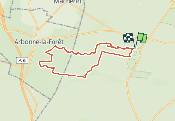
Trail Walking of 16.2 km to be discovered at Ile-de-France, Seine-et-Marne, Fontainebleau. This trail is proposed by GTarenne.

Description

RANDONNEE FAITE LE 22 MAI 2024
Randonnée au départ du parking des Gorges de Franchard (au fond du parking)
Prendre le chemin vers l'Ouest (balisage jaune et balisage bleu - Denecourt)
Après 2km, descendre par les escaliers (en bois) pour rejoindre le GR11 (possibilité avant la descente de poursuivre jusqu'au point de vue)
Suivre le GR11 qui traverse le Rocher des Hautes Plaines et les Rochers des Sablons
Continuer le GR jusqu'au croisement avec le chemin de la Basse Plaine (à suivre vers l'Est) et prendre ensuite au Sud (1er croisement) vers le chemin de Corne-Biche à prendre vers l'Ouest
Poursuivre jusqu'au chemin des Mariniers (à prendre vers le sud) puis suivre le 1er chemin à gauche qui monte vers la Tour de la Vierge (très beau point de vue) - final assez raide
A la Tour, descendre au sud vers la route de la Plaine de Chanfrey (à prendre vers l'est)
Continuer avec la route de Milly jusqu'au croisement avec le GR1 et le prendre vers le Nord
Traverser les rochers de Milly par la route de Cévise puis le route des Ventes Barbier
Le GR1 continue vers l'Est (GR1 commun avec le TMF balisage vert et blanc), le suivre jusqu'au parking des Gorges de Franchard

Elevation profile

Positioning

Country:
France
Region :
Ile-de-France
Department/Province :
Seine-et-Marne
Municipality :
Fontainebleau
Location:
Unknown
Start:(UTM)
473003 ; 5361825 (31U) N.

Trails nearby

Trail Walking Barbizon - Sentier des peintres - Photo
Walking
onftest

Walking

Medium
(11)
Barbizon, Ile-de-France, Seine-et-Marne, France
7.5 km | 8.2 km-effort
1h 25min
Yes
Trail Walking Fontainebleau - La Mare aux Fées 18km - Forêt de Fontainebleau - Photo
Walking
onftest

Walking

Medium
(5)
Fontainebleau, Ile-de-France, Seine-et-Marne, France
18 km | 22 km-effort
4h 41min
Yes
Trail Walking Fontainebleau - 3pi-150428 - DésertApremont-Jupiter - Photo
Walking
randodan

Walking

Easy
(1)
Fontainebleau, Ile-de-France, Seine-et-Marne, France
16 km | 19.4 km-effort
6h 30min
Yes
Trail Walking Fontainebleau - Rando mares aux fees Gilles18 km - Photo
Walking
GUIDE
jeanmarcMasson

Walking

Very difficult
(1)
Fontainebleau, Ile-de-France, Seine-et-Marne, France
17.8 km | 22 km-effort
4h 58min
Yes
Trail On foot Fontainebleau - Rando des trois châteaux parcours 42 km Fontainebleau Vaux le vicomte Blandy les tours - Photo
On foot
GUIDE
chessyca

On foot

Very difficult
Fontainebleau, Ile-de-France, Seine-et-Marne, France
43 km | 50 km-effort
11h 23min
No
Trail On foot Fontainebleau - SityTrail - JC 60 Fontainebleau, les rochers du long boyau, du Mt Morillon, des Demoiselles... - Photo
On foot

On foot

Difficult
(2)
Fontainebleau, Ile-de-France, Seine-et-Marne, France
14.6 km | 17.3 km-effort
3h 56min
Yes
Trail Walking Fontainebleau - La rando des 3 chateaux - Parcours 42 km - Photo
Walking
GUIDE
chessyca

Walking

Very difficult
Fontainebleau, Ile-de-France, Seine-et-Marne, France
43 km | 49 km-effort
7h 37min
No
Trail Walking Barbizon - Le tour du Grand Paris via le GR1 etape 14 Barbizon- Malesherbes - Photo
Walking
GUIDE
chessyca

Walking

Very difficult
Barbizon, Ile-de-France, Seine-et-Marne, France
35 km | 41 km-effort
6h 11min
No
Trail Walking Fontainebleau - Boucle 20 km Fontainebleau vert galant - Photo
Walking
GUIDE
chessyca

Walking

Easy
Fontainebleau, Ile-de-France, Seine-et-Marne, France
21 km | 24 km-effort
4h 35min
Yes


Close
My subscriptions