Trail Electric bike Peyreleau - Boucle  Mont Aigoual en partant de Peyreleau - Photo

Boucle Mont Aigoual en partant de Peyreleau

 franquen
franquen

User

© OpenStreetMap contributors
Length
Length
95 km
Max alt
Max alt
1561 m
Uphill gradient
Uphill gradient
1995 m
Km-Effort
Km-Effort  
121 km
Min alt
Min alt
395 m
Downhill gradient
Downhill gradient
1995 m
Boucle
Boucle
Yes
Creation date :
2024-05-22 08:09:24.433
Updated on :
2024-05-22 16:06:39.674

(0 Reviews)

Electric bike
Electric bike
5h46
Difficulty : Very easy

Scan this QR Code to open this trail in the SityTrail application

FREE GPS app for hiking

Logo SityTrail SityTrail

IGN / Geographical institutes

Download SityTrail from the App Store Download SityTrail from Google Play

Logo SityTrail SityTrail World

The world is yours!

Download SityTrail from the App Store Download SityTrail from Google Play Download SityTrail on Huawei AppGallery

About

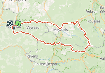
Trail Electric bike of 95 km to be discovered at Occitania, Aveyron, Peyreleau. This trail is proposed by franquen.

Description

Très belle rando en passant dans les gorges de la Jonte , puis au sommet du Mt Aigoual et retour sur le plateau. Rando un peu longue mais sans difficulté, attention aux batteries !

Elevation profile

Positioning

Country:
France
Region :
Occitania
Department/Province :
Aveyron
Municipality :
Peyreleau
Location:
Unknown
Start:(UTM)
516914 ; 4891462 (31T) N.

Trails nearby

Trail Walking Mostuéjouls - Cirque de Saint Marcellin - Mostuéjouls - Liaucous - Photo
Walking
tracegps

Walking

Medium
(1)
Mostuéjouls, Occitania, Aveyron, France
15.4 km | 24 km-effort
5h 0min
Yes
Trail Walking Le Rozier - Causse et gorges au pays des vautours  - Photo
Walking
GUIDE
nadinebondoux

Walking

Difficult
Le Rozier, Occitania, Lozère, France
27 km | 40 km-effort
7h 48min
No
Trail Walking Saint-Pierre-des-Tripiers - Cassagnes crête vallée Jonte et Tarn 12,2 km - Photo
Walking
GUIDE
rvapeldo

Walking

Medium
Saint-Pierre-des-Tripiers, Occitania, Lozère, France
12.6 km | 20 km-effort
5h 38min
No
Trail Walking Veyreau - J3 St Jean des Balmes Ermitage St Michel - Photo
Walking
ARPF

Walking

Easy
(2)
Veyreau, Occitania, Aveyron, France
9.6 km | 13.9 km-effort
3h 18min
Yes
Trail Walking Saint-Pierre-des-Tripiers - Les corniches du Méjean - Photo
Walking
ZURMELY

Walking

Medium
(3)
Saint-Pierre-des-Tripiers, Occitania, Lozère, France
6 km | 9.5 km-effort
2h 31min
Yes
Trail Walking Saint-Pierre-des-Tripiers - LL34-Corniches du Méjean - Photo
Walking
alainandrejoly

Walking

Difficult
(1)
Saint-Pierre-des-Tripiers, Occitania, Lozère, France
12.1 km | 25 km-effort
4h 51min
Yes
Trail Walking Saint-Pierre-des-Tripiers - vautour - Photo
Walking
aezret

Walking

Medium
(1)
Saint-Pierre-des-Tripiers, Occitania, Lozère, France
7.1 km | 12.3 km-effort
2h 59min
Yes
Trail Walking Le Rozier - Sur Les Hauteurs De Peyreleau - Photo
Walking
Patakk

Walking

Difficult
(2)
Le Rozier, Occitania, Lozère, France
10.4 km | 18.2 km-effort
4h 0min
Yes
Trail Walking Peyreleau - Le 815 - Peyreleau - Photo
Walking
tracegps

Walking

Easy
(1)
Peyreleau, Occitania, Aveyron, France
5.5 km | 10.5 km-effort
2h 0min
Yes


Close
My subscriptions