Trail Walking Pontis - pontis  st Hugues  - Photo
 sypat
sypat

User

© OpenStreetMap contributors
Length
Length
10.8 km
Max alt
Max alt
1518 m
Uphill gradient
Uphill gradient
417 m
Km-Effort
Km-Effort  
16.3 km
Min alt
Min alt
1113 m
Downhill gradient
Downhill gradient
416 m
Boucle
Boucle
Yes
Creation date :
2024-05-21 07:23:39.179
Updated on :
2024-05-21 10:43:26.455

(0 Reviews)

Walking
Walking
2h51
Difficulty : Easy

Scan this QR Code to open this trail in the SityTrail application

FREE GPS app for hiking

Logo SityTrail SityTrail

IGN / Geographical institutes

Download SityTrail from the App Store Download SityTrail from Google Play

Logo SityTrail SityTrail World

The world is yours!

Download SityTrail from the App Store Download SityTrail from Google Play Download SityTrail on Huawei AppGallery

About

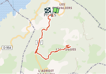
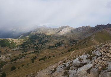
Trail Walking of 10.8 km to be discovered at Provence-Alpes-Côte d'Azur, Alpes-de-Haute-Provence, Pontis. This trail is proposed by sypat.

Description

Pontis St Hugues
repérage de chemin de rando
pour faire le col du morgonnet

Elevation profile

Photos

Positioning

Country:
France
Region :
Provence-Alpes-Côte d'Azur
Department/Province :
Alpes-de-Haute-Provence
Municipality :
Pontis
Location:
Unknown
Start:(UTM)
290002 ; 4931160 (32T) N.

Trails nearby

Trail Walking Chorges - Chanteloube et lac de Serre Ponçon - Photo
Walking
gildascb

Walking

Very easy
(2)
Chorges, Provence-Alpes-Côte d'Azur, Hautes-Alpes, France
5.9 km | 8.2 km-effort
1h 47min
Yes
Trail Walking Pontis - PONTIS , le dolmen  - Photo
Walking
RobinMicheline

Walking

Medium
(1)
Pontis, Provence-Alpes-Côte d'Azur, Alpes-de-Haute-Provence, France
12.9 km | 21 km-effort
3h 50min
Yes
Trail Walking Pontis - pic de Morgon par les ortals et les traverses  - Photo
Walking
GUIDE
orsel

Walking

Difficult
Pontis, Provence-Alpes-Côte d'Azur, Alpes-de-Haute-Provence, France
12.3 km | 26 km-effort
8h 49min
Yes
Trail Walking Pontis - Le Grand Morgon par la face nord 07/09/23 - Photo
Walking
GUIDE
R@ph

Walking

Difficult
Pontis, Provence-Alpes-Côte d'Azur, Alpes-de-Haute-Provence, France
7.8 km | 18.9 km-effort
4h 18min
Yes
Trail Walking Pontis - Morgon par les Traverses, retour par les Ortals - Photo
Walking
GUIDE
David25400

Walking

Very difficult
Pontis, Provence-Alpes-Côte d'Azur, Alpes-de-Haute-Provence, France
17.1 km | 33 km-effort
5h 49min
No
Trail Walking Pontis - Le Morgonnet - Photo
Walking
GUIDE
Specialized77

Walking

Medium
Pontis, Provence-Alpes-Côte d'Azur, Alpes-de-Haute-Provence, France
5.9 km | 10.6 km-effort
2h 46min
Yes
Trail Walking Pontis - Morgon par les Ortals - Photo
Walking
GUIDE
David25400

Walking

Difficult
Pontis, Provence-Alpes-Côte d'Azur, Alpes-de-Haute-Provence, France
15.6 km | 32 km-effort
6h 29min
Yes
Trail Walking Pontis - Pic du Morgon par Serre-Chiret - Photo
Walking
GUIDE
David25400

Walking

Difficult
Pontis, Provence-Alpes-Côte d'Azur, Alpes-de-Haute-Provence, France
14 km | 27 km-effort
4h 2min
Yes
Trail Mountain bike Savines-le-Lac - circuit de serre verger N°25 - Photo
Mountain bike
guariso

Mountain bike

Medium
(1)
Savines-le-Lac, Provence-Alpes-Côte d'Azur, Hautes-Alpes, France
9.8 km | 15.8 km-effort
1h 30min
No


Close
My subscriptions