![](/images/other/stat-length.png)
![Trail Electric bike Peyreleau - boucle des gorges du Tarn - Photo](https://media.geolcdn.com/t/1900/400/ext.pjpeg?maxdim=2&url=https%3A%2F%2Fstatic1.geolcdn.com%2Fsiteimages%2Fupload%2Ffiles%2F1524743154velo.jpg)
boucle des gorges du Tarn
franquen
User
![Length](/images/other/stat-length.png)
Length
50 km
![Max alt](https://static1.geolcdn.com/siteimages/upload/files/1508320355ic_sort_altitude_max_24dp.png)
Max alt
863 m
![Uphill gradient](https://static1.geolcdn.com/siteimages/upload/files/1508320355ic_sort_den_pos_24dp.png)
Uphill gradient
937 m
![Km-Effort](/images/other/stat-length.png)
Km-Effort
62 km
![Min alt](https://static1.geolcdn.com/siteimages/upload/files/1508320355ic_sort_altitude_min_24dp.png)
Min alt
355 m
![Downhill gradient](https://static1.geolcdn.com/siteimages/upload/files/1508320355ic_sort_den_neg_24dp.png)
Downhill gradient
921 m
![Boucle](https://static1.geolcdn.com/siteimages/upload/files/16400158638029165_repeat_loop_refresh_sync_direction_icon.png)
Boucle
No
Creation date :
2024-05-20 07:35:11.495
Updated on :
2024-05-20 16:51:42.456
![Electric bike](https://static1.geolcdn.com/sitytour/trail-icons/205.png)
9h06
Difficulty : Easy
![Scan this QR Code to open this trail in the SityTrail application](https://capi.geolives.com/qq0zvz2zws4bq2lad0pu/sitytour/trails/4061979/qr.png?size=200)
FREE GPS app for hiking
About
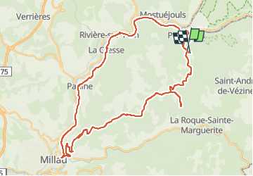
Trail Electric bike of 50 km to be discovered at Occitania, Aveyron, Peyreleau. This trail is proposed by franquen.
Description
Boucle en partant de Peyreleau, le long de la rive gauche du Tarn,
jusqu'à Millau. Retour par la D110 sur le plateau. Bon repas à l'auberge Maubert. un detour par le Chaos de Montpellier le Vieux et retour.
Positioning
Country:
France
Region :
Occitania
Department/Province :
Aveyron
Municipality :
Peyreleau
Location:
Unknown
Start:(Dec)
Start:(UTM)
516720 ; 4891533 (31T) N.
Comments
Trails nearby
![Trail Walking Mostuéjouls - Cirque de Saint Marcellin - Mostuéjouls - Liaucous - Photo](https://media.geolcdn.com/t/375/260/ext.jpg?maxdim=2&url=https%3A%2F%2Fservices.sitytrail.com%2FGeolivesWS%2FDownloadMedia.ashx%3FTrailID%3D173134%26Media%3D14690_6.jpg)
![Walking Walking](https://static1.geolcdn.com/sitytour/trail-icons/101.png)
Cirque de Saint Marcellin - Mostuéjouls - Liaucous
Walking
Medium
(1)
Mostuéjouls,
Occitania,
Aveyron,
France
![](/images/other/stat-length.png)
15.4 km | 24 km-effort
5h 0min
![](https://static1.geolcdn.com/siteimages/upload/files/16400158638029165_repeat_loop_refresh_sync_direction_icon.png)
Yes
![Trail Walking Le Rozier - Causse et gorges au pays des vautours - Photo](https://media.geolcdn.com/t/375/260/ext.jpg?maxdim=2&url=https%3A%2F%2Fmedia.geolcdn.com%2Ff%2Fcab4842f-73f8-42f5-b236-9c9a4da22964.jpg)
![Walking Walking](https://static1.geolcdn.com/sitytour/trail-icons/101.png)
Causse et gorges au pays des vautours
Walking
Difficult
Le Rozier,
Occitania,
Lozère,
France
![](/images/other/stat-length.png)
27 km | 40 km-effort
7h 48min
![](https://static1.geolcdn.com/siteimages/upload/files/16400158638029165_repeat_loop_refresh_sync_direction_icon.png)
No
![Trail Walking Saint-Pierre-des-Tripiers - Cassagnes crête vallée Jonte et Tarn 12,2 km - Photo](https://media.geolcdn.com/t/375/260/ext.jpg?maxdim=2&url=https%3A%2F%2Fmedia.geolcdn.com%2Ff%2F9473c7ff-c94b-41a9-84a9-d12f53c1c0cb.jpg)
![Walking Walking](https://static1.geolcdn.com/sitytour/trail-icons/101.png)
Cassagnes crête vallée Jonte et Tarn 12,2 km
Walking
Medium
Saint-Pierre-des-Tripiers,
Occitania,
Lozère,
France
![](/images/other/stat-length.png)
12.6 km | 20 km-effort
5h 38min
![](https://static1.geolcdn.com/siteimages/upload/files/16400158638029165_repeat_loop_refresh_sync_direction_icon.png)
No
![Trail Walking Veyreau - J3 St Jean des Balmes Ermitage St Michel - Photo](https://media.geolcdn.com/t/375/260/ext.jpg?maxdim=2&url=https%3A%2F%2Fstatic1.geolcdn.com%2Fsiteimages%2Fupload%2Ffiles%2F1553511878bg_sport_marche.png)
![Walking Walking](https://static1.geolcdn.com/sitytour/trail-icons/101.png)
J3 St Jean des Balmes Ermitage St Michel
Walking
Easy
(2)
Veyreau,
Occitania,
Aveyron,
France
![](/images/other/stat-length.png)
9.6 km | 13.9 km-effort
3h 18min
![](https://static1.geolcdn.com/siteimages/upload/files/16400158638029165_repeat_loop_refresh_sync_direction_icon.png)
Yes
![Trail Walking Saint-Pierre-des-Tripiers - Les corniches du Méjean - Photo](https://media.geolcdn.com/t/375/260/ext.jpg?maxdim=2&url=https%3A%2F%2Fstatic1.geolcdn.com%2Fsiteimages%2Fupload%2Ffiles%2F1553511878bg_sport_marche.png)
![Walking Walking](https://static1.geolcdn.com/sitytour/trail-icons/101.png)
Les corniches du Méjean
Walking
Medium
(3)
Saint-Pierre-des-Tripiers,
Occitania,
Lozère,
France
![](/images/other/stat-length.png)
6 km | 9.5 km-effort
2h 31min
![](https://static1.geolcdn.com/siteimages/upload/files/16400158638029165_repeat_loop_refresh_sync_direction_icon.png)
Yes
![Trail Walking Saint-Pierre-des-Tripiers - LL34-Corniches du Méjean - Photo](https://media.geolcdn.com/t/375/260/ext.jpg?maxdim=2&url=https%3A%2F%2Fstatic1.geolcdn.com%2Fsiteimages%2Fupload%2Ffiles%2F1553511878bg_sport_marche.png)
![Walking Walking](https://static1.geolcdn.com/sitytour/trail-icons/101.png)
LL34-Corniches du Méjean
Walking
Difficult
(1)
Saint-Pierre-des-Tripiers,
Occitania,
Lozère,
France
![](/images/other/stat-length.png)
12.1 km | 25 km-effort
4h 51min
![](https://static1.geolcdn.com/siteimages/upload/files/16400158638029165_repeat_loop_refresh_sync_direction_icon.png)
Yes
![Trail Walking Saint-Pierre-des-Tripiers - vautour - Photo](https://media.geolcdn.com/t/375/260/ext.jpg?maxdim=2&url=https%3A%2F%2Fstatic1.geolcdn.com%2Fsiteimages%2Fupload%2Ffiles%2F1553511878bg_sport_marche.png)
![Walking Walking](https://static1.geolcdn.com/sitytour/trail-icons/101.png)
vautour
Walking
Medium
(1)
Saint-Pierre-des-Tripiers,
Occitania,
Lozère,
France
![](/images/other/stat-length.png)
7.1 km | 12.3 km-effort
2h 59min
![](https://static1.geolcdn.com/siteimages/upload/files/16400158638029165_repeat_loop_refresh_sync_direction_icon.png)
Yes
![Trail Walking Le Rozier - Sur Les Hauteurs De Peyreleau - Photo](https://media.geolcdn.com/t/375/260/ext.jpg?maxdim=2&url=https%3A%2F%2Fstatic1.geolcdn.com%2Fsiteimages%2Fupload%2Ffiles%2F1553511878bg_sport_marche.png)
![Walking Walking](https://static1.geolcdn.com/sitytour/trail-icons/101.png)
Sur Les Hauteurs De Peyreleau
Walking
Difficult
(2)
Le Rozier,
Occitania,
Lozère,
France
![](/images/other/stat-length.png)
10.4 km | 18.2 km-effort
4h 0min
![](https://static1.geolcdn.com/siteimages/upload/files/16400158638029165_repeat_loop_refresh_sync_direction_icon.png)
Yes
![Trail Walking Peyreleau - Le 815 - Peyreleau - Photo](https://media.geolcdn.com/t/375/260/ext.jpg?maxdim=2&url=https%3A%2F%2Fstatic1.geolcdn.com%2Fsiteimages%2Fupload%2Ffiles%2F1553511878bg_sport_marche.png)
![Walking Walking](https://static1.geolcdn.com/sitytour/trail-icons/101.png)
Le 815 - Peyreleau
Walking
Easy
(1)
Peyreleau,
Occitania,
Aveyron,
France
![](/images/other/stat-length.png)
5.5 km | 10.5 km-effort
2h 0min
![](https://static1.geolcdn.com/siteimages/upload/files/16400158638029165_repeat_loop_refresh_sync_direction_icon.png)
Yes