Trail Walking Vannes-le-Châtel - forêt de Meine - Photo
 Jenn8
Jenn8

User

© OpenStreetMap contributors
Length
Length
9.2 km
Max alt
Max alt
419 m
Uphill gradient
Uphill gradient
183 m
Km-Effort
Km-Effort  
11.7 km
Min alt
Min alt
314 m
Downhill gradient
Downhill gradient
182 m
Boucle
Boucle
Yes
Creation date :
2024-05-20 11:55:20.919
Updated on :
2024-05-20 14:53:40.529

(0 Reviews)

Walking
Walking
2h57
Difficulty : Easy

Scan this QR Code to open this trail in the SityTrail application

FREE GPS app for hiking

Logo SityTrail SityTrail

IGN / Geographical institutes

Download SityTrail from the App Store Download SityTrail from Google Play

Logo SityTrail SityTrail World

The world is yours!

Download SityTrail from the App Store Download SityTrail from Google Play Download SityTrail on Huawei AppGallery

About

Trail Walking of 9.2 km to be discovered at Grand Est, Meurthe-et-Moselle, Vannes-le-Châtel. This trail is proposed by Jenn8.

Description

du 15 sept au 01 mars sinon interdit, cause chasse.

Elevation profile

Positioning

Country:
France
Region :
Grand Est
Department/Province :
Meurthe-et-Moselle
Municipality :
Vannes-le-Châtel
Location:
Unknown
Start:(UTM)
706138 ; 5385956 (31U) N.

Trails nearby

Trail Walking Bulligny - BULLIGNY - LE BOIS BRULE - Photo
Walking
jean-marie.parachini

Walking

Easy
Bulligny, Grand Est, Meurthe-et-Moselle, France
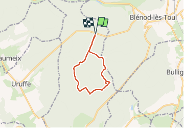
8.8 km | 11.4 km-effort
4h 11min
Yes
Trail Walking Allamps - Allamps  - Photo
Walking
topnature !

Walking

Medium
Allamps, Grand Est, Meurthe-et-Moselle, France
18.6 km | 22 km-effort
3h 24min
No
Trail Walking Bulligny - bullig - Photo
Walking
Nila81

Walking

Medium
Bulligny, Grand Est, Meurthe-et-Moselle, France
7.4 km | 9.5 km-effort
2h 5min
No
Trail Walking Charmes-la-Côte - Circuit saint -Fiacre - Photo
Walking
Samuel88300

Walking

Charmes-la-Côte, Grand Est, Meurthe-et-Moselle, France
11 km | 14.3 km-effort
2h 59min
Yes
Trail Walking Rigny-Saint-Martin - st fiacre-choloy - Photo
Walking
mannequ1

Walking

Medium
Rigny-Saint-Martin, Grand Est, Meuse, France
18.6 km | 23 km-effort
3h 56min
Yes
Trail Nordic walking Domgermain - Marche au palteau de Domgermain - Photo
Nordic walking
SANTINI

Nordic walking

Easy
Domgermain, Grand Est, Meurthe-et-Moselle, France
8.6 km | 10.1 km-effort
1h 29min
Yes
Trail Walking Blénod-lès-Toul - blenod les Toul - Photo
Walking
Jenn8

Walking

Easy
Blénod-lès-Toul, Grand Est, Meurthe-et-Moselle, France
8.3 km | 10.3 km-effort
2h 50min
Yes
Trail Walking Blénod-lès-Toul - rando 12km vers Bulligny - Photo
Walking
sandra54570

Walking

Difficult
Blénod-lès-Toul, Grand Est, Meurthe-et-Moselle, France
11.9 km | 15.6 km-effort
1h 36min
Yes
Trail sport Domgermain - Domgermain  - Photo
sport
Arnaud Leon

sport

Very easy
Domgermain, Grand Est, Meurthe-et-Moselle, France
5.8 km | 6.9 km-effort
Unknown
No


Close
My subscriptions