Trail Walking Molines-en-Queyras - Le canal de Rouchas Frach (1) - Photo
 yjguerin
yjguerin

User

© OpenStreetMap contributors
Length
Length
7.4 km
Max alt
Max alt
2275 m
Uphill gradient
Uphill gradient
98 m
Km-Effort
Km-Effort  
9 km
Min alt
Min alt
2153 m
Downhill gradient
Downhill gradient
189 m
Boucle
Boucle
No
Creation date :
2024-05-20 12:39:52.387
Updated on :
2024-06-26 16:45:34.369

(0 Reviews)

Walking
Walking
2h02
Difficulty : Medium

Scan this QR Code to open this trail in the SityTrail application

FREE GPS app for hiking

Logo SityTrail SityTrail

IGN / Geographical institutes

Download SityTrail from the App Store Download SityTrail from Google Play

Logo SityTrail SityTrail World

The world is yours!

Download SityTrail from the App Store Download SityTrail from Google Play Download SityTrail on Huawei AppGallery

About

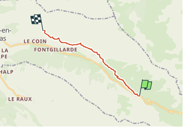
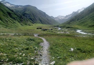
Trail Walking of 7.4 km to be discovered at Provence-Alpes-Côte d'Azur, Hautes-Alpes, Molines-en-Queyras. This trail is proposed by yjguerin.

Description

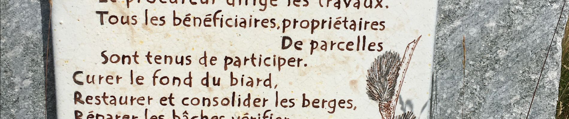
Ancien canal d'irrigation ayant fonctionné 700 ans, objet d'une oeuvre artistique, éducative et patrimoniale originale.
Plus d'informations sur https://fontgillarde.fr

Elevation profile

Photos

Positioning

Country:
France
Region :
Provence-Alpes-Côte d'Azur
Department/Province :
Hautes-Alpes
Municipality :
Molines-en-Queyras
Location:
Unknown
Start:(UTM)
337070 ; 4951648 (32T) N.

Trails nearby

Trail Walking Saint-Véran - Lac de la Blanche, lacs blanchet et pic de Caramantran - Photo
Walking
GUIDE
amiral13

Walking

Medium
(2)
Saint-Véran, Provence-Alpes-Côte d'Azur, Hautes-Alpes, France
13.1 km | 23 km-effort
6h 12min
Yes
Trail Snowshoes Molines-en-Queyras - Pont de Lariane - Col de Longet - Observatoire et Pic de Château Renard - Photo
Snowshoes
GUIDE
Pierre Lefèvre

Snowshoes

Medium
Molines-en-Queyras, Provence-Alpes-Côte d'Azur, Hautes-Alpes, France
16.1 km | 30 km-effort
5h 0min
Yes
Trail Walking Molines-en-Queyras - le tour du Pain de Sucre - Photo
Walking
GUIDE
amiral13

Walking

Difficult
Molines-en-Queyras, Provence-Alpes-Côte d'Azur, Hautes-Alpes, France
8.1 km | 16 km-effort
4h 57min
Yes
Trail Walking Saint-Véran - Pic de Caramantran - Photo
Walking
GUIDE
R@ph

Walking

Very difficult
Saint-Véran, Provence-Alpes-Côte d'Azur, Hautes-Alpes, France
12 km | 23 km-effort
4h 41min
Yes
Trail Walking Molines-en-Queyras - Lacs Foréant, Egorgéou, Baricle et de l'Eychassier - Photo
Walking
GUIDE
amiral13

Walking

Medium
Molines-en-Queyras, Provence-Alpes-Côte d'Azur, Hautes-Alpes, France
13.8 km | 24 km-effort
6h 20min
Yes
Trail Walking Molines-en-Queyras - le pain de sucre - Photo
Walking
GUIDE
amiral13

Walking

Difficult
(1)
Molines-en-Queyras, Provence-Alpes-Côte d'Azur, Hautes-Alpes, France
4.5 km | 10.1 km-effort
4h 39min
Yes
Trail Other activity Molines-en-Queyras - ski tour du Rouchon - Photo
Other activity
CYCLOHC

Other activity

Medium
(2)
Molines-en-Queyras, Provence-Alpes-Côte d'Azur, Hautes-Alpes, France
8.6 km | 20 km-effort
5h 24min
No
Trail Walking Pontechianale - ITALIE BELLINO CHIANALE . TOUR DU PAIN DU SUCRE . AR. O  - Photo
Walking
RobinMicheline

Walking

Medium
Pontechianale, Piemont, Cuneo, Italy
7.7 km | 11.3 km-effort
2h 36min
Yes
Trail Walking Pontechianale - pain de sucre circuit  - Photo
Walking
Youcef Atallah

Walking

Medium
Pontechianale, Piemont, Cuneo, Italy
5.9 km | 11.9 km-effort
2h 12min
No


Close
My subscriptions