![](/images/other/stat-length.png)
![Trail Walking Sainte-Marie-du-Mont - Sangle et Rocher des Belles ombres - Photo](https://media.geolcdn.com/t/1900/400/ext.pjpeg?maxdim=2&url=https%3A%2F%2Fstatic1.geolcdn.com%2Fsiteimages%2Fupload%2Ffiles%2F1553511878bg_sport_marche.png)
Sangle et Rocher des Belles ombres
loicthev
User
![Length](/images/other/stat-length.png)
Length
11.1 km
![Max alt](https://static1.geolcdn.com/siteimages/upload/files/1508320355ic_sort_altitude_max_24dp.png)
Max alt
1835 m
![Uphill gradient](https://static1.geolcdn.com/siteimages/upload/files/1508320355ic_sort_den_pos_24dp.png)
Uphill gradient
702 m
![Km-Effort](/images/other/stat-length.png)
Km-Effort
20 km
![Min alt](https://static1.geolcdn.com/siteimages/upload/files/1508320355ic_sort_altitude_min_24dp.png)
Min alt
1400 m
![Downhill gradient](https://static1.geolcdn.com/siteimages/upload/files/1508320355ic_sort_den_neg_24dp.png)
Downhill gradient
707 m
![Boucle](https://static1.geolcdn.com/siteimages/upload/files/16400158638029165_repeat_loop_refresh_sync_direction_icon.png)
Boucle
Yes
Creation date :
2024-05-17 07:03:22.391
Updated on :
2024-05-17 11:48:43.666
![Walking](https://static1.geolcdn.com/sitytour/trail-icons/101.png)
3h17
Difficulty : Medium
![Scan this QR Code to open this trail in the SityTrail application](https://capi.geolives.com/qq0zvz2zws4bq2lad0pu/sitytour/trails/4057574/qr.png?size=200)
FREE GPS app for hiking
About
Trail Walking of 11.1 km to be discovered at Auvergne-Rhône-Alpes, Isère, Sainte-Marie-du-Mont. This trail is proposed by loicthev.
Description
randonnée Sangle Rocher des Belles ombres
Pré Orcet > Sangle des Belles ombres > Rocher des Belles ombres > pas et croix de l'Alpe > Pré Orcet
Positioning
Country:
France
Region :
Auvergne-Rhône-Alpes
Department/Province :
Isère
Municipality :
Sainte-Marie-du-Mont
Location:
Unknown
Start:(Dec)
Start:(UTM)
729834 ; 5033853 (31T) N.
Comments
Trails nearby
![Trail Walking Saint-Pierre-d'Entremont - chartreuse varvats fouda blanc pinet - Photo](https://media.geolcdn.com/t/375/260/3ade212f-cb78-41d4-b551-255bd725eded.jpg&format=jpg&maxdim=2)
![Walking Walking](https://static1.geolcdn.com/sitytour/trail-icons/101.png)
chartreuse varvats fouda blanc pinet
Walking
Difficult
(1)
Saint-Pierre-d'Entremont,
Auvergne-Rhône-Alpes,
Savoy,
France
![](/images/other/stat-length.png)
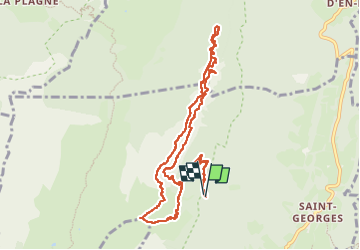
14.4 km | 27 km-effort
5h 27min
![](https://static1.geolcdn.com/siteimages/upload/files/16400158638029165_repeat_loop_refresh_sync_direction_icon.png)
Yes
![Trail Walking Chapareillan - Le Mont Granier 1933m, depuis Bellecombe - Photo](https://media.geolcdn.com/t/375/260/ext.jpg?maxdim=2&url=https%3A%2F%2Fservices.sitytrail.com%2FGeolivesWS%2FDownloadMedia.ashx%3FTrailID%3D106476%26Media%3D10999_1.jpg)
![Walking Walking](https://static1.geolcdn.com/sitytour/trail-icons/101.png)
Le Mont Granier 1933m, depuis Bellecombe
Walking
Difficult
(1)
Chapareillan,
Auvergne-Rhône-Alpes,
Isère,
France
![](/images/other/stat-length.png)
14.8 km | 35 km-effort
8h 45min
![](https://static1.geolcdn.com/siteimages/upload/files/16400158638029165_repeat_loop_refresh_sync_direction_icon.png)
Yes
![Trail Walking Sainte-Marie-du-Mont - Les Belles Ombres - Sangle et Rochers - Sainte Marie du Mont - Photo](https://media.geolcdn.com/t/375/260/ext.jpg?maxdim=2&url=https%3A%2F%2Fservices.sitytrail.com%2FGeolivesWS%2FDownloadMedia.ashx%3FTrailID%3D106447%26Media%3D10957_1.jpg)
![Walking Walking](https://static1.geolcdn.com/sitytour/trail-icons/101.png)
Les Belles Ombres - Sangle et Rochers - Sainte Marie du Mont
Walking
Medium
(1)
Sainte-Marie-du-Mont,
Auvergne-Rhône-Alpes,
Isère,
France
![](/images/other/stat-length.png)
8.6 km | 16.2 km-effort
5h 0min
![](https://static1.geolcdn.com/siteimages/upload/files/16400158638029165_repeat_loop_refresh_sync_direction_icon.png)
Yes
![Trail Walking Entremont-le-Vieux - Le Mont Granier par la cheminée de Tencovaz - Photo](https://media.geolcdn.com/t/375/260/ext.jpg?maxdim=2&url=https%3A%2F%2Fservices.sitytrail.com%2FGeolivesWS%2FDownloadMedia.ashx%3FTrailID%3D103708%26Media%3D6232_1.jpg)
![Walking Walking](https://static1.geolcdn.com/sitytour/trail-icons/101.png)
Le Mont Granier par la cheminée de Tencovaz
Walking
Difficult
(3)
Entremont-le-Vieux,
Auvergne-Rhône-Alpes,
Savoy,
France
![](/images/other/stat-length.png)
9.6 km | 24 km-effort
5h 0min
![](https://static1.geolcdn.com/siteimages/upload/files/16400158638029165_repeat_loop_refresh_sync_direction_icon.png)
Yes
![Trail Snowshoes Saint-Pierre-d'Entremont - La Croix de l'Alpe depuis les Varvats - Photo](https://media.geolcdn.com/t/375/260/ext.jpg?maxdim=2&url=https%3A%2F%2Fservices.sitytrail.com%2FGeolivesWS%2FDownloadMedia.ashx%3FTrailID%3D103120%26Media%3D4867_1.jpg)
![Snowshoes Snowshoes](https://static1.geolcdn.com/sitytour/trail-icons/504.png)
La Croix de l'Alpe depuis les Varvats
Snowshoes
Medium
(1)
Saint-Pierre-d'Entremont,
Auvergne-Rhône-Alpes,
Savoy,
France
![](/images/other/stat-length.png)
12 km | 24 km-effort
5h 0min
![](https://static1.geolcdn.com/siteimages/upload/files/16400158638029165_repeat_loop_refresh_sync_direction_icon.png)
Yes
![Trail Walking Saint-Vincent-de-Mercuze - 38 cascades d alloix - Photo](https://media.geolcdn.com/t/375/260/ac959965-e9e6-43ac-868c-d1afc5ef4777.jpg&format=jpg&maxdim=2)
![Walking Walking](https://static1.geolcdn.com/sitytour/trail-icons/101.png)
38 cascades d alloix
Walking
Medium
Saint-Vincent-de-Mercuze,
Auvergne-Rhône-Alpes,
Isère,
France
![](/images/other/stat-length.png)
10.7 km | 20 km-effort
5h 42min
![](https://static1.geolcdn.com/siteimages/upload/files/16400158638029165_repeat_loop_refresh_sync_direction_icon.png)
No
![Trail Walking Entremont-le-Vieux - Le Granier par Tencovaz - Photo](https://media.geolcdn.com/t/375/260/0a6d7d9d-3ccb-410e-b45a-8510ed0c4da6.jpg&format=jpg&maxdim=2)
![Walking Walking](https://static1.geolcdn.com/sitytour/trail-icons/101.png)
Le Granier par Tencovaz
Walking
Difficult
Entremont-le-Vieux,
Auvergne-Rhône-Alpes,
Savoy,
France
![](/images/other/stat-length.png)
10.9 km | 27 km-effort
4h 46min
![](https://static1.geolcdn.com/siteimages/upload/files/16400158638029165_repeat_loop_refresh_sync_direction_icon.png)
Yes
![Trail Walking Entremont-le-Vieux - 38 outheran chartreuse - Photo](https://media.geolcdn.com/t/375/260/0718cfa5-92e3-4faf-aaef-e8783760fb24.jpg&format=jpg&maxdim=2)
![Walking Walking](https://static1.geolcdn.com/sitytour/trail-icons/101.png)
38 outheran chartreuse
Walking
Medium
Entremont-le-Vieux,
Auvergne-Rhône-Alpes,
Savoy,
France
![](/images/other/stat-length.png)
16.5 km | 29 km-effort
6h 57min
![](https://static1.geolcdn.com/siteimages/upload/files/16400158638029165_repeat_loop_refresh_sync_direction_icon.png)
Yes
![Trail Walking Sainte-Marie-du-Mont - Passage de la Rousse - Photo](https://media.geolcdn.com/t/375/260/3d59ba9c-1b18-4c8b-84d9-d9ac619ac9d2.jpg&format=jpg&maxdim=2)
![Walking Walking](https://static1.geolcdn.com/sitytour/trail-icons/101.png)
Passage de la Rousse
Walking
Medium
Sainte-Marie-du-Mont,
Auvergne-Rhône-Alpes,
Isère,
France
![](/images/other/stat-length.png)
10.6 km | 21 km-effort
4h 46min
![](https://static1.geolcdn.com/siteimages/upload/files/16400158638029165_repeat_loop_refresh_sync_direction_icon.png)
Yes