Trail Walking Chamonix-Mont-Blanc - Brèche Puiseux - Photo
 loicthev
loicthev

User

© OpenStreetMap contributors
Length
Length
28 km
Max alt
Max alt
3679 m
Uphill gradient
Uphill gradient
1182 m
Km-Effort
Km-Effort  
53 km
Min alt
Min alt
1044 m
Downhill gradient
Downhill gradient
3809 m
Boucle
Boucle
No
Creation date :
2024-05-12 08:21:26.07
Updated on :
2024-05-13 23:09:30.989

(0 Reviews)

Walking
Walking
4h01
Difficulty : Very difficult
Touring skiing
Touring skiing
6h01
Difficulty : Difficult

Scan this QR Code to open this trail in the SityTrail application

FREE GPS app for hiking

Logo SityTrail SityTrail

IGN / Geographical institutes

Download SityTrail from the App Store Download SityTrail from Google Play

Logo SityTrail SityTrail World

The world is yours!

Download SityTrail from the App Store Download SityTrail from Google Play Download SityTrail on Huawei AppGallery

About

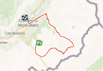
Trail Walking of 28 km to be discovered at Auvergne-Rhône-Alpes, Upper Savoy, Chamonix-Mont-Blanc. This trail is proposed by loicthev.

Description

Ski de rando Brèche Puiseux en traversée W>E
Aiguille du midi > Vallée Blanche > La Salle à Manger > remontée glacier des Périades > Brèche Puiseux > Descente glacier du mont Mallet puis glacier de Leschaux > Mer de Glace > Montenvers > Chamonix
13/05/2024
Alexandre

Elevation profile

Positioning

Country:
France
Region :
Auvergne-Rhône-Alpes
Department/Province :
Upper Savoy
Municipality :
Chamonix-Mont-Blanc
Location:
Unknown
Start:(UTM)
336245 ; 5082905 (32T) N.

Trails nearby

Trail Walking Chamonix-Mont-Blanc - J8 - Cascade du Dard - Photo
Walking

Walking

Medium
(1)
Chamonix-Mont-Blanc, Auvergne-Rhône-Alpes, Upper Savoy, France
6.1 km | 9.4 km-effort
1h 45min
Yes
Trail Running Chamonix-Mont-Blanc - The North Face© Ultra Trail du Mont-Blanc© UTMB 2008 - Photo
Running
tracegps

Running

Very difficult
(2)
Chamonix-Mont-Blanc, Auvergne-Rhône-Alpes, Upper Savoy, France
160 km | 288 km-effort
46h 0min
Yes
Trail Walking Chamonix-Mont-Blanc - Circuit de la Mer de Glace - Chamonix Mont Blanc - Photo
Walking
tracegps

Walking

Difficult
(2)
Chamonix-Mont-Blanc, Auvergne-Rhône-Alpes, Upper Savoy, France
13.3 km | 24 km-effort
5h 30min
Yes
Trail Walking Chamonix-Mont-Blanc - Glacier des Bossons Les Houches Chamonix - Photo
Walking
tracegps

Walking

Difficult
(2)
Chamonix-Mont-Blanc, Auvergne-Rhône-Alpes, Upper Savoy, France
13.1 km | 28 km-effort
5h 0min
Yes
Trail Walking Chamonix-Mont-Blanc - Chalet des Pyramides 1895m 11.7.22 - Photo
Walking
GUIDE
fredetpascale

Walking

Medium
Chamonix-Mont-Blanc, Auvergne-Rhône-Alpes, Upper Savoy, France
7.7 km | 15.2 km-effort
3h 30min
Yes
Trail Walking Chamonix-Mont-Blanc - La cascade du dard - Photo
Walking
GUIDE
pascalou73

Walking

Medium
Chamonix-Mont-Blanc, Auvergne-Rhône-Alpes, Upper Savoy, France
8.2 km | 13.6 km-effort
2h 0min
Yes
Trail Walking Chamonix-Mont-Blanc - Le lac bleus - Photo
Walking
GUIDE
pascalou73

Walking

Medium
Chamonix-Mont-Blanc, Auvergne-Rhône-Alpes, Upper Savoy, France
17.1 km | 35 km-effort
6h 57min
Yes
Trail Other activity Chamonix-Mont-Blanc - vallée blanche - Photo
Other activity
jnpollet

Other activity

Difficult
(1)
Chamonix-Mont-Blanc, Auvergne-Rhône-Alpes, Upper Savoy, France
19.8 km | 30 km-effort
3h 21min
No
Trail Walking Chamonix-Mont-Blanc - J24 - R24 - Cascade du Dard - Lac des Gaillands 
 - Photo
Walking

Walking

Medium
Chamonix-Mont-Blanc, Auvergne-Rhône-Alpes, Upper Savoy, France
7 km | 11 km-effort
2h 1min
Yes


Close
My subscriptions