![](/images/other/stat-length.png)
![Trail On foot Le Tilleul - Le Tilleul - Etretat - Photo](https://media.geolcdn.com/t/1900/400/ext.pjpeg?maxdim=2&url=https%3A%2F%2Fstatic1.geolcdn.com%2Fsiteimages%2Fupload%2Ffiles%2F1545311037marcheuse_200dpi.jpg)
Le Tilleul - Etretat
AACLARANDO
User
![Length](/images/other/stat-length.png)
Length
11.3 km
![Max alt](https://static1.geolcdn.com/siteimages/upload/files/1508320355ic_sort_altitude_max_24dp.png)
Max alt
111 m
![Uphill gradient](https://static1.geolcdn.com/siteimages/upload/files/1508320355ic_sort_den_pos_24dp.png)
Uphill gradient
232 m
![Km-Effort](/images/other/stat-length.png)
Km-Effort
14.4 km
![Min alt](https://static1.geolcdn.com/siteimages/upload/files/1508320355ic_sort_altitude_min_24dp.png)
Min alt
5 m
![Downhill gradient](https://static1.geolcdn.com/siteimages/upload/files/1508320355ic_sort_den_neg_24dp.png)
Downhill gradient
230 m
![Boucle](https://static1.geolcdn.com/siteimages/upload/files/16400158638029165_repeat_loop_refresh_sync_direction_icon.png)
Boucle
Yes
Creation date :
2024-05-11 15:58:50.109
Updated on :
2024-05-11 16:06:01.238
![On foot](https://static1.geolcdn.com/sitytour/trail-icons/100.png)
3h16
Difficulty : Easy
![Scan this QR Code to open this trail in the SityTrail application](https://capi.geolives.com/qq0zvz2zws4bq2lad0pu/sitytour/trails/4050653/qr.png?size=200)
FREE GPS app for hiking
About
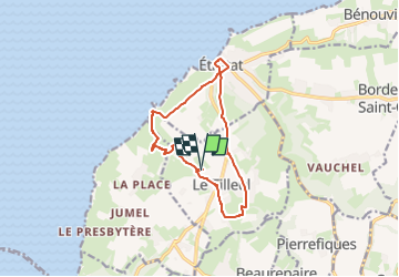
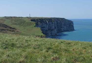
Trail On foot of 11.3 km to be discovered at Normandy, Seine-Maritime, Le Tilleul. This trail is proposed by AACLARANDO.
Description
départ au parking du Tilleul en haut de la Valleuse. Se diriger vers Etretat, avec la traversée d'Etretat. Rejoindre Le Tilleul et le parking de départ.
Positioning
Country:
France
Region :
Normandy
Department/Province :
Seine-Maritime
Municipality :
Le Tilleul
Location:
Unknown
Start:(Dec)
Start:(UTM)
297825 ; 5507538 (31U) N.
Comments
Trails nearby
![Trail Walking Étretat - étretat golf - Photo](https://media.geolcdn.com/t/375/260/ext.jpg?maxdim=2&url=https%3A%2F%2Fservices.sitytrail.com%2FGeolivesWS%2FDownloadMedia.ashx%3FTrailID%3D302991%26Media%3Dfix__20140518154039.jpg)
![Walking Walking](https://static1.geolcdn.com/sitytour/trail-icons/101.png)
étretat golf
Walking
Easy
(1)
Étretat,
Normandy,
Seine-Maritime,
France
![](/images/other/stat-length.png)
4.7 km | 6.7 km-effort
1h 42min
![](https://static1.geolcdn.com/siteimages/upload/files/16400158638029165_repeat_loop_refresh_sync_direction_icon.png)
Yes
![Trail Walking Étretat - Le sentier nature des falaises d'Etretat - Photo](https://media.geolcdn.com/t/375/260/ext.jpg?maxdim=2&url=https%3A%2F%2Fservices.sitytrail.com%2FGeolivesWS%2FDownloadMedia.ashx%3FTrailID%3D172695%26Media%3D14074_5.jpg)
![Walking Walking](https://static1.geolcdn.com/sitytour/trail-icons/101.png)
Le sentier nature des falaises d'Etretat
Walking
Medium
(2)
Étretat,
Normandy,
Seine-Maritime,
France
![](/images/other/stat-length.png)
9.3 km | 12.7 km-effort
3h 30min
![](https://static1.geolcdn.com/siteimages/upload/files/16400158638029165_repeat_loop_refresh_sync_direction_icon.png)
Yes
![Trail Mountain bike Étretat - Etretat Yport - Photo](https://media.geolcdn.com/t/375/260/ext.jpg?maxdim=2&url=https%3A%2F%2Fservices.sitytrail.com%2FGeolivesWS%2FDownloadMedia.ashx%3FTrailID%3D104928%26Media%3D8466_1.jpg)
![Mountain bike Mountain bike](https://static1.geolcdn.com/sitytour/trail-icons/202.png)
Etretat Yport
Mountain bike
Difficult
(4)
Étretat,
Normandy,
Seine-Maritime,
France
![](/images/other/stat-length.png)
35 km | 43 km-effort
3h 0min
![](https://static1.geolcdn.com/siteimages/upload/files/16400158638029165_repeat_loop_refresh_sync_direction_icon.png)
Yes
![Trail Walking Le Tilleul - La Valleuse d'Antifer - Photo](https://media.geolcdn.com/t/375/260/5e0af125-3ee6-4ef5-8573-7b5656fc4a5d.jpg&format=jpg&maxdim=2)
![Walking Walking](https://static1.geolcdn.com/sitytour/trail-icons/101.png)
La Valleuse d'Antifer
Walking
Difficult
(1)
Le Tilleul,
Normandy,
Seine-Maritime,
France
![](/images/other/stat-length.png)
12.5 km | 16.3 km-effort
3h 42min
![](https://static1.geolcdn.com/siteimages/upload/files/16400158638029165_repeat_loop_refresh_sync_direction_icon.png)
Yes
![Trail Walking La Poterie-Cap-d'Antifer - Etretat - Photo](https://media.geolcdn.com/t/375/260/ext.jpg?maxdim=2&url=https%3A%2F%2Fstatic1.geolcdn.com%2Fsiteimages%2Fupload%2Ffiles%2F1553511878bg_sport_marche.png)
![Walking Walking](https://static1.geolcdn.com/sitytour/trail-icons/101.png)
Etretat
Walking
Easy
(1)
La Poterie-Cap-d'Antifer,
Normandy,
Seine-Maritime,
France
![](/images/other/stat-length.png)
10.6 km | 14.4 km-effort
3h 8min
![](https://static1.geolcdn.com/siteimages/upload/files/16400158638029165_repeat_loop_refresh_sync_direction_icon.png)
Yes
![Trail Walking Étretat - Etretat les falaises - Photo](https://media.geolcdn.com/t/375/260/ext.jpg?maxdim=2&url=https%3A%2F%2Fstatic1.geolcdn.com%2Fsiteimages%2Fupload%2Ffiles%2F1553511878bg_sport_marche.png)
![Walking Walking](https://static1.geolcdn.com/sitytour/trail-icons/101.png)
Etretat les falaises
Walking
Easy
(1)
Étretat,
Normandy,
Seine-Maritime,
France
![](/images/other/stat-length.png)
7.6 km | 10.2 km-effort
2h 56min
![](https://static1.geolcdn.com/siteimages/upload/files/16400158638029165_repeat_loop_refresh_sync_direction_icon.png)
Yes
![Trail Walking Étretat - GR21 Etretat à Fécamp - Photo](https://media.geolcdn.com/t/375/260/ext.jpg?maxdim=2&url=https%3A%2F%2Fstatic1.geolcdn.com%2Fsiteimages%2Fupload%2Ffiles%2F1553511878bg_sport_marche.png)
![Walking Walking](https://static1.geolcdn.com/sitytour/trail-icons/101.png)
GR21 Etretat à Fécamp
Walking
Easy
(1)
Étretat,
Normandy,
Seine-Maritime,
France
![](/images/other/stat-length.png)
16.4 km | 21 km-effort
4h 42min
![](https://static1.geolcdn.com/siteimages/upload/files/16400158638029165_repeat_loop_refresh_sync_direction_icon.png)
No
![Trail Walking Bénouville - L'aiguille de Belval - Photo](https://media.geolcdn.com/t/375/260/e5015acf-207d-4f0a-9245-b6a712853198.jpg&format=jpg&maxdim=2)
![Walking Walking](https://static1.geolcdn.com/sitytour/trail-icons/101.png)
L'aiguille de Belval
Walking
Medium
Bénouville,
Normandy,
Seine-Maritime,
France
![](/images/other/stat-length.png)
9 km | 11.1 km-effort
2h 31min
![](https://static1.geolcdn.com/siteimages/upload/files/16400158638029165_repeat_loop_refresh_sync_direction_icon.png)
Yes
![Trail Walking Étretat - Falaise d'Etretat - Photo](https://media.geolcdn.com/t/375/260/f69257bf-8597-4797-8e18-5f418d814afc.jpg&format=jpg&maxdim=2)
![Walking Walking](https://static1.geolcdn.com/sitytour/trail-icons/101.png)
Falaise d'Etretat
Walking
Easy
Étretat,
Normandy,
Seine-Maritime,
France
![](/images/other/stat-length.png)
9 km | 11.8 km-effort
2h 19min
![](https://static1.geolcdn.com/siteimages/upload/files/16400158638029165_repeat_loop_refresh_sync_direction_icon.png)
Yes