![](/images/other/stat-length.png)
![Trail Walking Hotton - RF-Lu-03 - Raccourci - Sur la Calestienne, entre Ardenne et Famenne : Hotton - Photo](https://media.geolcdn.com/t/1900/400/ext.pjpeg?maxdim=2&url=https%3A%2F%2Fservices.sitytrail.com%2FGeolivesWS%2FDownloadMedia.ashx%3FTrailID%3D404700%26Media%3D95ef949a-6cc3-4187-ac60-b8b9a599f2b0.jpg)
RF-Lu-03 - Raccourci - Sur la Calestienne, entre Ardenne et Famenne : Hotton
GR Rando
Randonnez sur et autour des GR ® wallons (Sentiers de Grande Randonnée). PRO
![Length](/images/other/stat-length.png)
![Max alt](https://static1.geolcdn.com/siteimages/upload/files/1508320355ic_sort_altitude_max_24dp.png)
![Uphill gradient](https://static1.geolcdn.com/siteimages/upload/files/1508320355ic_sort_den_pos_24dp.png)
![Km-Effort](/images/other/stat-length.png)
![Min alt](https://static1.geolcdn.com/siteimages/upload/files/1508320355ic_sort_altitude_min_24dp.png)
![Downhill gradient](https://static1.geolcdn.com/siteimages/upload/files/1508320355ic_sort_den_neg_24dp.png)
![Boucle](https://static1.geolcdn.com/siteimages/upload/files/16400158638029165_repeat_loop_refresh_sync_direction_icon.png)
![Walking](https://static1.geolcdn.com/sitytour/trail-icons/101.png)
1h45
Difficulty : Unknown
![Scan this QR Code to open this trail in the SityTrail application](https://capi.geolives.com/qq0zvz2zws4bq2lad0pu/sitytour/trails/404700/qr.png?size=200)
FREE GPS app for hiking
About
Trail Walking of 6.5 km to be discovered at Wallonia, Luxembourg, Hotton. This trail is proposed by GR Rando.
Description
Raccourci - Sur la Calestienne, entre Ardenne et Famenne : Hotton
Dans quel type de paysage randonnons-nous ?
Le but de cette rando est d’« escalader » un sommet dominant la vallée de l’Ourthe et situé au milieu d’une belle forêt.
Où démarrons-nous ?
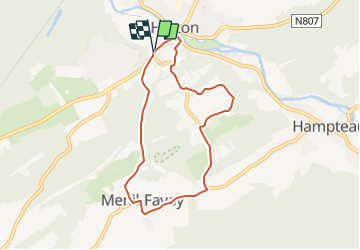
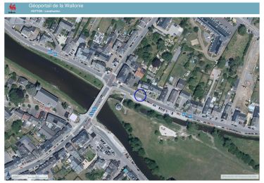
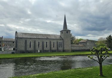
Au carrefour de la route de Ménil-Favay, non loin du pont sur l’Ourthe à Hotton (carte Michelin n° 34, pli R/21).
Comment y arriver ?
En descendant la N86, venant de Marche, suivre cette route (en entrant dans le village de Hotton) jusqu’au carrefour de la route de Menil-Favay à droite. OU, en venant de Durbuy sur la N86, traverser le pont sur l’Ourthe à Hotton puis continuer en face dans la rue Émile Parfonry jusqu’au premier carrefour. La route de gauche monte à Menil-Favay. Une aire de pique-nique avec parking se trouve, un peu avant ce carrefour, à gauche en montant de Durbuy, OU peu après ce même carrefour, à droite en descendant la route de Marche.
Combien de kilomètres ?
11,6 km. En suivant une petite route de campagne (très peu fréquentée) sur environ 800 mètres, il est possible de réduire l’itinéraire à 6,5 km.
Quelle difficulté ?
La première partie de la randonnée est en montée continue, mais douce. Le retour est en descente. Donc, balade relativement facile.
Sur quel GR randonnons-nous ?
Nous suivons les balises du GR 577 (« Tour de la Famenne ») depuis le pont de Hotton jusqu’à Menil-Favay, puis rejoignons le GR 57 (« Vallée de l’Ourthe et Sentier du Nord ») qui guidera nos pas, au retour, jusqu’à Hotton.
Quelle est la carte IGN de réf??rence ?
Carte IGN au 1:20 000, 55/5-6 « Hotton - Rendeux ».
Que découvrons-nous aujourd’hui ?
Nous jouerons aux spéléologues dans les grottes de Hotton, puis nous pourrons assister à une séance de « cinéma dynamique » à Marche.
Transports en commun ?
Au pont sur l’Ourthe, à 350 mètres du point de départ et d’arrivée de cette randonnée, les bus TEC 11, 11/2 et 13 proposent de nombreuses relations vers les gares de Marloie et de Melreux, sur les lignes 162 (Namur - Luxembourg) et 43 (Herstal - Jemelle).
Positioning
Comments
Trails nearby
![Trail Walking Hotton - RB-LUX-04 - En Famenne - Photo](https://media.geolcdn.com/t/375/260/ext.jpg?maxdim=2&url=https%3A%2F%2Fservices.sitytrail.com%2FGeolivesWS%2FDownloadMedia.ashx%3FTrailID%3D179613%26Media%3Dc1eccb03-838f-4466-b103-ba3011ffaee0.jpg)
![Walking Walking](https://static1.geolcdn.com/sitytour/trail-icons/101.png)
Walking
![](/images/other/stat-length.png)
![](https://static1.geolcdn.com/siteimages/upload/files/16400158638029165_repeat_loop_refresh_sync_direction_icon.png)
![Trail Walking Hotton - RF-Lu-03 Sur la Calestienne, entre Ardenne et Famenne : Hotton - Photo](https://media.geolcdn.com/t/375/260/ext.jpg?maxdim=2&url=https%3A%2F%2Fservices.sitytrail.com%2FGeolivesWS%2FDownloadMedia.ashx%3FTrailID%3D407838%26Media%3D5ce28d25-1425-4e98-96ff-2c6c15aabb08.jpg)
![Walking Walking](https://static1.geolcdn.com/sitytour/trail-icons/101.png)
Walking
![](/images/other/stat-length.png)
![](https://static1.geolcdn.com/siteimages/upload/files/16400158638029165_repeat_loop_refresh_sync_direction_icon.png)
![Trail Walking Hotton - Fronville - Monteuville - Petihan - Photo](https://media.geolcdn.com/t/375/260/ext.jpg?maxdim=2&url=https%3A%2F%2Fservices.sitytrail.com%2FGeolivesWS%2FDownloadMedia.ashx%3FTrailID%3D1067628%26Media%3Dfix__20181106130901.jpg)
![Walking Walking](https://static1.geolcdn.com/sitytour/trail-icons/101.png)
Walking
![](/images/other/stat-length.png)
![](https://static1.geolcdn.com/siteimages/upload/files/16400158638029165_repeat_loop_refresh_sync_direction_icon.png)
![Trail Walking Hotton - Saint-Pierre - Photo](https://media.geolcdn.com/t/375/260/ext.jpg?maxdim=2&url=https%3A%2F%2Fservices.sitytrail.com%2FGeolivesWS%2FDownloadMedia.ashx%3FTrailID%3D204152%26Media%3D4d13859b-e8ea-464e-b6f5-80f7a1b7659d.jpg)
![Walking Walking](https://static1.geolcdn.com/sitytour/trail-icons/101.png)
Walking
![](/images/other/stat-length.png)
![](https://static1.geolcdn.com/siteimages/upload/files/16400158638029165_repeat_loop_refresh_sync_direction_icon.png)
![Trail Walking Hotton - De werpin a werpin via Trinal - Photo](https://media.geolcdn.com/t/375/260/ext.jpg?maxdim=2&url=https%3A%2F%2Fservices.sitytrail.com%2FGeolivesWS%2FDownloadMedia.ashx%3FTrailID%3D225931%26Media%3Dfix__20131007161453.jpg)
![Walking Walking](https://static1.geolcdn.com/sitytour/trail-icons/101.png)
Walking
![](/images/other/stat-length.png)
![](https://static1.geolcdn.com/siteimages/upload/files/16400158638029165_repeat_loop_refresh_sync_direction_icon.png)
![Trail Walking Hotton - 20241015 - TOTEMUS HOTTON - 5.4 Km - Photo](https://media.geolcdn.com/t/375/260/d43cf3cd-7fde-4960-b7e9-583dcb543dfc.jpeg&format=jpg&maxdim=2)
![Walking Walking](https://static1.geolcdn.com/sitytour/trail-icons/101.png)
Walking
![](/images/other/stat-length.png)
![](https://static1.geolcdn.com/siteimages/upload/files/16400158638029165_repeat_loop_refresh_sync_direction_icon.png)
![Trail sport Hotton - 2024-07-29_09h57m47_gpxfile - Photo](https://media.geolcdn.com/t/375/260/ext.jpg?maxdim=2&url=https%3A%2F%2Fsecurestorage.geolives.com%2Fsitytour%2Ftrail-bg%2Fdefault.jpg)
sport
![](/images/other/stat-length.png)
![](https://static1.geolcdn.com/siteimages/upload/files/16400158638029165_repeat_loop_refresh_sync_direction_icon.png)
![Trail Walking Hotton - Balade à Hotton - Photo](https://media.geolcdn.com/t/375/260/768efbbe-c567-45b1-bd57-69176b5f50b6.jpeg&format=jpg&maxdim=2)
![Walking Walking](https://static1.geolcdn.com/sitytour/trail-icons/101.png)
Walking
![](/images/other/stat-length.png)
![](https://static1.geolcdn.com/siteimages/upload/files/16400158638029165_repeat_loop_refresh_sync_direction_icon.png)