Trail Running Le Beausset - PLATEAU DE SIOU BLANC - TETE DE LA CADE - Photo

PLATEAU DE SIOU BLANC - TETE DE LA CADE

 jpb83
jpb83

User

© OpenStreetMap contributors
Length
Length
8.8 km
Max alt
Max alt
526 m
Uphill gradient
Uphill gradient
206 m
Km-Effort
Km-Effort  
11.6 km
Min alt
Min alt
351 m
Downhill gradient
Downhill gradient
206 m
Boucle
Boucle
Yes
Creation date :
2015-04-06 00:00:00.0
Updated on :
2015-04-06 00:00:00.0

(0 Reviews)

Running
Running
1h30
Difficulty : Medium

Scan this QR Code to open this trail in the SityTrail application

FREE GPS app for hiking

Logo SityTrail SityTrail

IGN / Geographical institutes

Download SityTrail from the App Store Download SityTrail from Google Play

Logo SityTrail SityTrail World

The world is yours!

Download SityTrail from the App Store Download SityTrail from Google Play Download SityTrail on Huawei AppGallery

About

Trail Running of 8.8 km to be discovered at Provence-Alpes-Côte d'Azur, Var, Le Beausset. This trail is proposed by jpb83.

Description

Le départ se situe à la maison des quatre frères.

Elevation profile

Positioning

Country:
France
Region :
Provence-Alpes-Côte d'Azur
Department/Province :
Var
Municipality :
Le Beausset
Location:
Unknown
Start:(UTM)
728535 ; 4790835 (31T) N.

Trails nearby

Trail Walking Le Beausset - Trace_Quatre_Freres - Photo
Walking
GUIDE
affinetataille

Walking

Very difficult
(1)
Le Beausset, Provence-Alpes-Côte d'Azur, Var, France
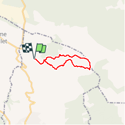
14.8 km | 19.6 km-effort
4h 26min
Yes
Trail Walking Le Beausset - Tête du Cade par abime de Maramouyé - Photo
Walking
sonneville

Walking

Very easy
(1)
Le Beausset, Provence-Alpes-Côte d'Azur, Var, France
12.4 km | 16.1 km-effort
3h 36min
Yes
Trail Walking Le Beausset - le beausset abime de Maramouyé - Photo
Walking
bernir

Walking

Very easy
(1)
Le Beausset, Provence-Alpes-Côte d'Azur, Var, France
9.6 km | 13.4 km-effort
4h 32min
Yes
Trail Walking Signes - grotte du mounoi signes - Photo
Walking
marchev

Walking

Medium
(1)
Signes, Provence-Alpes-Côte d'Azur, Var, France
17 km | 21 km-effort
4h 45min
Yes
Trail Walking La Cadière-d'Azur - LA CADIERE  - Photo
Walking
michelpaulin

Walking

Medium
(1)
La Cadière-d'Azur, Provence-Alpes-Côte d'Azur, Var, France
10.4 km | 14.4 km-effort
3h 16min
Yes
Trail Walking Le Castellet - Roche Redonne depuis Ste Anne du Castelet - Photo
Walking
Daniel.BRUN-PICARD

Walking

Difficult
Le Castellet, Provence-Alpes-Côte d'Azur, Var, France
11 km | 15.7 km-effort
3h 34min
Yes
Trail Walking La Cadière-d'Azur - la Cadière d'Azur 01-03-2024 - Photo
Walking
Christiancordin

Walking

Easy
La Cadière-d'Azur, Provence-Alpes-Côte d'Azur, Var, France
6.3 km | 8.3 km-effort
2h 26min
Yes
Trail sport Le Castellet - Vallon du canet 27.02.24 - Photo
sport
michelpaulin

sport

Very easy
Le Castellet, Provence-Alpes-Côte d'Azur, Var, France
14.9 km | 19.6 km-effort
Unknown
Yes
Trail Walking Signes - Vallon des Martyrs Signes - Photo
Walking
sonneville

Walking

Difficult
Signes, Provence-Alpes-Côte d'Azur, Var, France
14.9 km | 18.3 km-effort
4h 9min
Yes


Close
My subscriptions