Trail Walking Profondeville - Les 7 Meuses de Sequoia inspirée d'une proposition de Namur - Photo

Les 7 Meuses de Sequoia inspirée d'une proposition de Namur

 Thyves
Thyves

User

© OpenStreetMap contributors
Length
Length
7.2 km
Max alt
Max alt
272 m
Uphill gradient
Uphill gradient
210 m
Km-Effort
Km-Effort  
10 km
Min alt
Min alt
78 m
Downhill gradient
Downhill gradient
208 m
Boucle
Boucle
Yes
Creation date :
2024-05-06 14:02:27.307
Updated on :
2024-05-25 10:20:54.278

(0 Reviews)

Walking
Walking
2h16
Difficulty : Medium

Scan this QR Code to open this trail in the SityTrail application

FREE GPS app for hiking

Logo SityTrail SityTrail

IGN / Geographical institutes

Download SityTrail from the App Store Download SityTrail from Google Play

Logo SityTrail SityTrail World

The world is yours!

Download SityTrail from the App Store Download SityTrail from Google Play Download SityTrail on Huawei AppGallery

About

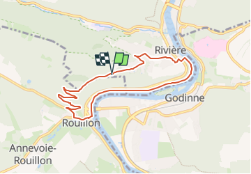
Trail Walking of 7.2 km to be discovered at Wallonia, Namur, Profondeville. This trail is proposed by Thyves.

Description

Longue de 7,2km cette promenade part du parking de l'établissement "Les 7 Meuses" Non loin de l'émetteur de la RTBF dont l’impressionnant édifice de métal domine toute la vallée de ses 163 mètres pour un poids de 150 tonne. A l'arrière du parking il et possible d'accéder au point de vue, le spectacle est grandiose!
Démarrons la promenade en nous dirigeant vers le bois. La descente s'amorce lentement à travers bois avant d'entamer une série de lacets qui une fois les premiers bâtiments dépassés, via un étroit sentier à gauche, nous permet de rejoindre la route de Rouillon/Mettet. Attention lors de la traversée! Nous rejoignons la chaussée de Namur/Dinant via une ruelle. De l'autre côté de la chaussée une petite rue nous mène vers le chemin de halage que nous empruntons vers la gauche. Nous longeons la Meuse sur une distance d'environ 2,5 km avant de quitter la Meuse pour gravir les quelques 170 mètres de dénivelé qui nous séparent du parking! Cette dernière montée passe très proche de la piste d'envol des parapentes et ailes delta, Tentant?  

Elevation profile

Positioning

Country:
Belgium
Region :
Wallonia
Department/Province :
Namur
Municipality :
Profondeville
Location:
Rivière
Start:(UTM)
632176 ; 5579651 (31U) N.

Trails nearby

Trail Walking Profondeville - GG-Na-19_ Lustin - Namur - Photo
Walking
PRO

Walking

Very difficult
(13)
Profondeville, Wallonia, Namur, Belgium
22 km | 28 km-effort
6h 7min
No
Trail Walking Anhée - RB-Na-22-raccourci_Vignobles-et-Jardins-d’eau - Photo
Walking
PRO

Walking

Very difficult
(6)
Anhée, Wallonia, Namur, Belgium
16.7 km | 21 km-effort
4h 52min
Yes
Trail Walking Anhée - RB-Na-22_Vignobles-et-Jardins-d’eau - Photo
Walking
PRO

Walking

Very difficult
(11)
Anhée, Wallonia, Namur, Belgium
19.5 km | 25 km-effort
5h 46min
Yes
Trail Walking Yvoir - RB-Na-21-Terres seigneuriales et carrières de la vallée du Bocq - Photo
Walking
PRO

Walking

Very difficult
(6)
Yvoir, Wallonia, Namur, Belgium
22 km | 30 km-effort
6h 51min
Yes
Trail Walking Profondeville - RB-Na-20-Raccourci-2_Paysages_entre_Meuse_et_Burnot - Photo
Walking
PRO

Walking

Very difficult
(11)
Profondeville, Wallonia, Namur, Belgium
14.6 km | 22 km-effort
4h 53min
Yes
Trail Walking Profondeville - RB-Na-20-Paysages_entre_Meuse_et_Burnot - Photo
Walking
PRO

Walking

Very difficult
(16)
Profondeville, Wallonia, Namur, Belgium
18.5 km | 26 km-effort
5h 55min
Yes
Trail Walking Yvoir - GG2-Na-38_Godinne-Dinant (2021-11-04) - Photo
Walking
PRO

Walking

Very difficult
(6)
Yvoir, Wallonia, Namur, Belgium
19.5 km | 27 km-effort
6h 13min
No
Trail Walking Anhée - RF-Na-05 Annevoie, côté Jardins_Grande-boucle - Photo
Walking
PRO

Walking

Medium
(11)
Anhée, Wallonia, Namur, Belgium
11.3 km | 14.5 km-effort
3h 6min
Yes
Trail Walking Anhée - RF-Na-05 Annevoie, côté Jardins_Petite-boucle - Photo
Walking
PRO

Walking

Easy
(7)
Anhée, Wallonia, Namur, Belgium
7.4 km | 10 km-effort
2h 7min
Yes


Close
My subscriptions