Trail Motorbike Unknown - Koblenz - Eupen - Photo
© OpenStreetMap contributors
Length
Length
167 km
Max alt
Max alt
641 m
Uphill gradient
Uphill gradient
2691 m
Km-Effort
Km-Effort  
203 km
Min alt
Min alt
60 m
Downhill gradient
Downhill gradient
2625 m
Boucle
Boucle
No
Creation date :
2024-05-05 14:16:32.264
Updated on :
2024-05-05 14:17:10.568

(0 Reviews)

Motorbike
Motorbike
0m
Difficulty : Very easy

Scan this QR Code to open this trail in the SityTrail application

FREE GPS app for hiking

Logo SityTrail SityTrail

IGN / Geographical institutes

Download SityTrail from the App Store Download SityTrail from Google Play

Logo SityTrail SityTrail World

The world is yours!

Download SityTrail from the App Store Download SityTrail from Google Play Download SityTrail on Huawei AppGallery

About

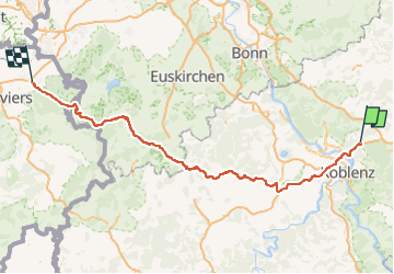
Trail Motorbike of 167 km to be discovered at Rhineland-Palatinate, Westerwaldkreis. This trail is proposed by Bernard Lejeune.

Elevation profile

Positioning

Country:
Germany
Region :
Rhineland-Palatinate
Department/Province :
Westerwaldkreis
Municipality :
Unknown
Location:
Unknown
Start:(UTM)
404652 ; 5589628 (32U) N.

Trails nearby

Trail On foot Bendorf - Wäller Tour Brexbachschluchtweg - Photo
On foot
GUIDE+

On foot

Easy
Bendorf, Rhineland-Palatinate, Landkreis Mayen-Koblenz, Germany
10.9 km | 14.7 km-effort
3h 20min
No
Trail On foot Hillscheid - Köppelweg 1 - Photo
On foot
GUIDE+

On foot

Easy
Hillscheid, Rhineland-Palatinate, Westerwaldkreis, Germany
11.3 km | 14.7 km-effort
3h 19min
No
Trail On foot Bendorf - Saynsteig - Photo
On foot
GUIDE+

On foot

Easy
Bendorf, Rhineland-Palatinate, Landkreis Mayen-Koblenz, Germany
7.4 km | 10.9 km-effort
2h 29min
No
Trail On foot Hundsdorf - Rundweg Ransbach-Baumbach - Photo
On foot
GUIDE+

On foot

Easy
Hundsdorf, Rhineland-Palatinate, Westerwaldkreis, Germany
6.4 km | 8.4 km-effort
1h 54min
No


Close
My subscriptions