Nordlingen - Koblenz SityTrail > Trails > Outdoor > Germany > Bavaria > Landkreis Donau-Ries > Nördlingen SityTrail > Trails > Outdoor > Germany > Bavaria > Landkreis Donau-Ries > Nördlingen Nordlingen - Koblenz Bernard Lejeune User 3D © OpenStreetMap contributors Length 420 km Max alt 635 m Uphill gradient 5210 m Km-Effort 490 km Min alt 111 m Downhill gradient 5430 m Boucle No Creation date : 2024-05-05 14:07:43.416 Updated on : 2024-05-05 14:08:16.748 (0 Reviews) Motorbike 0m Difficulty : Very easy FREE GPS app for hiking SityTrail IGN / Geographical institutes SityTrail World The world is yours! About Trail Motorbike of 420 km to be discovered at Bavaria, Landkreis Donau-Ries, Nördlingen. This trail is proposed by Bernard Lejeune. Legends | More details (PDF) Elevation profile Legends > 15% 15% - 10% 10% - 5% flat 5% - 10% 10% - 15% 15% - 30% > 30% Positioning Country: Germany Region : Bavaria Department/Province : Landkreis Donau-Ries Municipality : Nördlingen Location: Unknown Start:(Dec) 48.85158897083359 / 10.488231182098389 Start:(UTM) 609174 ; 5412026 (32U) N. Comments Please log in to post a review or rate the element Trails nearby GUIDE+ Schäferweg On foot Medium Nördlingen, Bavaria, Landkreis Donau-Ries, Germany 
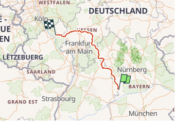
18.5 km | 23 km-effort 5h 8min Yes