![](/images/other/stat-length.png)
![Trail Walking Thonac - Boucle de Maillol n°12 / Thonac - Photo](https://media.geolcdn.com/t/1900/400/ext.pjpeg?maxdim=2&url=https%3A%2F%2Fstatic1.geolcdn.com%2Fsiteimages%2Fupload%2Ffiles%2F1553511878bg_sport_marche.png)
Boucle de Maillol n°12 / Thonac
fanthou
User
![Length](/images/other/stat-length.png)
Length
8.4 km
![Max alt](https://static1.geolcdn.com/siteimages/upload/files/1508320355ic_sort_altitude_max_24dp.png)
Max alt
225 m
![Uphill gradient](https://static1.geolcdn.com/siteimages/upload/files/1508320355ic_sort_den_pos_24dp.png)
Uphill gradient
192 m
![Km-Effort](/images/other/stat-length.png)
Km-Effort
11 km
![Min alt](https://static1.geolcdn.com/siteimages/upload/files/1508320355ic_sort_altitude_min_24dp.png)
Min alt
71 m
![Downhill gradient](https://static1.geolcdn.com/siteimages/upload/files/1508320355ic_sort_den_neg_24dp.png)
Downhill gradient
204 m
![Boucle](https://static1.geolcdn.com/siteimages/upload/files/16400158638029165_repeat_loop_refresh_sync_direction_icon.png)
Boucle
No
Creation date :
2024-05-02 13:49:49.689
Updated on :
2024-05-02 13:50:52.274
![Walking](https://static1.geolcdn.com/sitytour/trail-icons/101.png)
2h30
Difficulty : Medium
![Scan this QR Code to open this trail in the SityTrail application](https://capi.geolives.com/qq0zvz2zws4bq2lad0pu/sitytour/trails/4037552/qr.png?size=200)
FREE GPS app for hiking
About
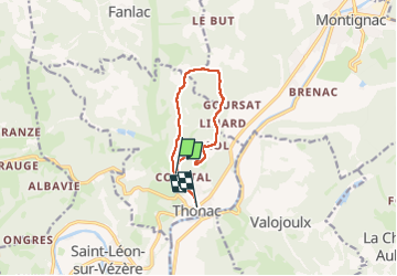
Trail Walking of 8.4 km to be discovered at New Aquitaine, Dordogne, Thonac. This trail is proposed by fanthou.
Description
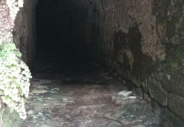
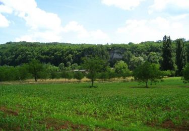
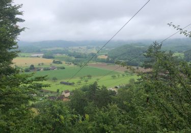
Une promenade autour du "Thot Espace Cro-Magnon" La randonnée commence par une montée, la suite du parcours est moins difficile. Cheminement dans les espaces naturels pour atteindre deux points de vue et deux hameaux.
Positioning
Country:
France
Region :
New Aquitaine
Department/Province :
Dordogne
Municipality :
Thonac
Location:
Unknown
Start:(Dec)
Start:(UTM)
351168 ; 4987995 (31T) N.
Comments
Trails nearby
![Trail Walking Montignac-Lascaux - Balade Montignac Dordogne - Photo](https://media.geolcdn.com/t/375/260/df48718e-2f64-4737-9eaa-1f12102a550a.jpg&format=jpg&maxdim=2)
![Walking Walking](https://static1.geolcdn.com/sitytour/trail-icons/101.png)
Balade Montignac Dordogne
Walking
Easy
Montignac-Lascaux,
New Aquitaine,
Dordogne,
France
![](/images/other/stat-length.png)
3 km | 3.8 km-effort
1h 17min
![](https://static1.geolcdn.com/siteimages/upload/files/16400158638029165_repeat_loop_refresh_sync_direction_icon.png)
Yes
![Trail Walking Saint-Léon-sur-Vézère - Boucle de Haute-Claire St Léon sur Vézère - Photo](https://media.geolcdn.com/t/375/260/6b8d4051-3369-48b4-85b3-aee55415b67f.jpg&format=jpg&maxdim=2)
![Walking Walking](https://static1.geolcdn.com/sitytour/trail-icons/101.png)
Boucle de Haute-Claire St Léon sur Vézère
Walking
Medium
Saint-Léon-sur-Vézère,
New Aquitaine,
Dordogne,
France
![](/images/other/stat-length.png)
12.3 km | 17 km-effort
3h 8min
![](https://static1.geolcdn.com/siteimages/upload/files/16400158638029165_repeat_loop_refresh_sync_direction_icon.png)
Yes
![Trail Walking Peyzac-le-Moustier - Sensei24. Roque saint christophe - Photo](https://media.geolcdn.com/t/375/260/91b857a2-44a5-482e-ba5b-0816305726ff.jpg&format=jpg&maxdim=2)
![Walking Walking](https://static1.geolcdn.com/sitytour/trail-icons/101.png)
Sensei24. Roque saint christophe
Walking
Difficult
Peyzac-le-Moustier,
New Aquitaine,
Dordogne,
France
![](/images/other/stat-length.png)
16.2 km | 0 m-effort
4h 21min
![](https://static1.geolcdn.com/siteimages/upload/files/16400158638029165_repeat_loop_refresh_sync_direction_icon.png)
Yes
![Trail Walking Thonac - vezere_28reduit - Photo](https://media.geolcdn.com/t/375/260/ext.jpg?maxdim=2&url=https%3A%2F%2Fstatic1.geolcdn.com%2Fsiteimages%2Fupload%2Ffiles%2F1553511878bg_sport_marche.png)
![Walking Walking](https://static1.geolcdn.com/sitytour/trail-icons/101.png)
vezere_28reduit
Walking
Medium
(1)
Thonac,
New Aquitaine,
Dordogne,
France
![](/images/other/stat-length.png)
9.2 km | 13.1 km-effort
2h 48min
![](https://static1.geolcdn.com/siteimages/upload/files/16400158638029165_repeat_loop_refresh_sync_direction_icon.png)
Yes
![Trail Walking Peyzac-le-Moustier - vezere_11 - Photo](https://media.geolcdn.com/t/375/260/ext.jpg?maxdim=2&url=https%3A%2F%2Fstatic1.geolcdn.com%2Fsiteimages%2Fupload%2Ffiles%2F1553511878bg_sport_marche.png)
![Walking Walking](https://static1.geolcdn.com/sitytour/trail-icons/101.png)
vezere_11
Walking
Medium
(1)
Peyzac-le-Moustier,
New Aquitaine,
Dordogne,
France
![](/images/other/stat-length.png)
8 km | 11.7 km-effort
2h 26min
![](https://static1.geolcdn.com/siteimages/upload/files/16400158638029165_repeat_loop_refresh_sync_direction_icon.png)
Yes
![Trail Walking Montignac-Lascaux - vezere_9 - Photo](https://media.geolcdn.com/t/375/260/ext.jpg?maxdim=2&url=https%3A%2F%2Fstatic1.geolcdn.com%2Fsiteimages%2Fupload%2Ffiles%2F1553511878bg_sport_marche.png)
![Walking Walking](https://static1.geolcdn.com/sitytour/trail-icons/101.png)
vezere_9
Walking
Medium
(1)
Montignac-Lascaux,
New Aquitaine,
Dordogne,
France
![](/images/other/stat-length.png)
13.5 km | 17.9 km-effort
3h 48min
![](https://static1.geolcdn.com/siteimages/upload/files/16400158638029165_repeat_loop_refresh_sync_direction_icon.png)
Yes
![Trail Mountain bike Saint-Léon-sur-Vézère - Rando VTT Silex 2013 - Saint Léon sur Vézère - Photo](https://media.geolcdn.com/t/375/260/ext.jpg?maxdim=2&url=https%3A%2F%2Fservices.sitytrail.com%2FGeolivesWS%2FDownloadMedia.ashx%3FTrailID%3D317058%26Media%3D16206_6.jpg)
![Mountain bike Mountain bike](https://static1.geolcdn.com/sitytour/trail-icons/202.png)
Rando VTT Silex 2013 - Saint Léon sur Vézère
Mountain bike
Difficult
Saint-Léon-sur-Vézère,
New Aquitaine,
Dordogne,
France
![](/images/other/stat-length.png)
41 km | 54 km-effort
4h 15min
![](https://static1.geolcdn.com/siteimages/upload/files/16400158638029165_repeat_loop_refresh_sync_direction_icon.png)
Yes
![Trail Mountain bike Saint-Léon-sur-Vézère - De Saint Léon-sur-Vézère au Verdoyant - Photo](https://media.geolcdn.com/t/375/260/ext.jpg?maxdim=2&url=https%3A%2F%2Fservices.sitytrail.com%2FGeolivesWS%2FDownloadMedia.ashx%3FTrailID%3D215098%26Media%3D15680_4.jpg)
![Mountain bike Mountain bike](https://static1.geolcdn.com/sitytour/trail-icons/202.png)
De Saint Léon-sur-Vézère au Verdoyant
Mountain bike
Difficult
Saint-Léon-sur-Vézère,
New Aquitaine,
Dordogne,
France
![](/images/other/stat-length.png)
25 km | 34 km-effort
3h 0min
![](https://static1.geolcdn.com/siteimages/upload/files/16400158638029165_repeat_loop_refresh_sync_direction_icon.png)
No
![Trail Walking Montignac-Lascaux - Montignac-peyzac - Photo](https://media.geolcdn.com/t/375/260/414c003e-9c11-405c-9eff-b9b60e428354.jpg&format=jpg&maxdim=2)
![Walking Walking](https://static1.geolcdn.com/sitytour/trail-icons/101.png)
Montignac-peyzac
Walking
Medium
Montignac-Lascaux,
New Aquitaine,
Dordogne,
France
![](/images/other/stat-length.png)
26 km | 36 km-effort
6h 57min
![](https://static1.geolcdn.com/siteimages/upload/files/16400158638029165_repeat_loop_refresh_sync_direction_icon.png)
No