Trail  Ablon-sur-Seine - 2024-05-01_20h40m45_94xl7-18-la-promenade-de-l-orge-29-km-par-jean-luc-ibp-70 (1) - Photo

2024-05-01_20h40m45_94xl7-18-la-promenade-de-l-orge-29-km-par-jean-luc-ibp-70 (1)

© OpenStreetMap contributors
Length
Length
29 km
Max alt
Max alt
85 m
Uphill gradient
Uphill gradient
332 m
Km-Effort
Km-Effort  
33 km
Min alt
Min alt
33 m
Downhill gradient
Downhill gradient
304 m
Boucle
Boucle
No
Creation date :
2024-05-01 18:40:46.65
Updated on :
2024-05-01 18:40:48.446

(0 Reviews)


Scan this QR Code to open this trail in the SityTrail application

FREE GPS app for hiking

Logo SityTrail SityTrail

IGN / Geographical institutes

Download SityTrail from the App Store Download SityTrail from Google Play

Logo SityTrail SityTrail World

The world is yours!

Download SityTrail from the App Store Download SityTrail from Google Play Download SityTrail on Huawei AppGallery

About

Trail of 29 km to be discovered at Ile-de-France, Val-de-Marne, Ablon-sur-Seine. This trail is proposed by jpryerres.

Description

[img]https://4.bp.blogspot.com/-CBUmrUw11Uo/Wtr_c5QVTSI/AAAAAAAAPL4/18f8zkojvuQ3yH17tt2Md3CAeGiWpXpOQCLcBGAs/s1600/RONG-ConvertImage.icoo[/img]   [b]Rando Club Yerrois[/b]


[img]https://4.bp.blogspot.com/-CBUmrUw11Uo/Wtr_c5QVTSI/AAAAAAAAPL4/18f8zkojvuQ3yH17tt2Md3CAeGiWpXpOQCLcBGAs/s1600/RONG-ConvertImage.icoo[/img]   [b]Rando Club Yerrois[/b]

[b]Date[/b] :  Dimanche 28 Janvier 2018
[b]Animateur[/b] : Jean Luc
[b]Groupe[/b] : 30 km
[b]Effectif[/b] : 10aine
[b]Vidéo relive[/b] :[url]https://youtu.be/ospD69my1a0[/url]

[b]Remarque particulière[/b] : Départ d'Ablon (parking difficile et probablement impossible en semaine ) et retour par le train depuis Arpajon (3 euros 50)

[b]Avertissement[/b] Toutes les randonnées répertoriées dans la randothèque du [b]R[/b]ando [b]C[/b]lub [b]Y[/b]errois ont été tracées par l'un de nos animateurs, puis reconnues et enfin effectuées avec un groupe. Pour votre sécurité, regardez toujours la date à laquelle la sortie a été effectuée - Nous tachons de mentionner des conditions météos particulières ou les difficultés éventuelles. N'oubliez jamais les consignes élémentaires de sécurité.

Elevation profile

Positioning

Country:
France
Region :
Ile-de-France
Department/Province :
Val-de-Marne
Municipality :
Ablon-sur-Seine
Location:
Unknown
Start:(UTM)
457384 ; 5397173 (31U) N.

Trails nearby

Trail Walking Juvisy-sur-Orge - GRP CV-IDF 2023 - Photo
Walking
clalaur

Walking

Difficult
(1)
Juvisy-sur-Orge, Ile-de-France, Essonne, France
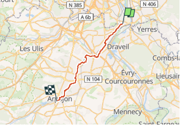
14.8 km | 17 km-effort
3h 52min
No
Trail Walking Montgeron - J 38 Montgeron la Pelouse, forêt de Sénart - Photo
Walking

Walking

Difficult
(3)
Montgeron, Ile-de-France, Essonne, France
12.4 km | 13.3 km-effort
3h 1min
Yes
Trail Walking Yerres - Boucle 30 km Sénart et bords de l'YERRES - Photo
Walking
GUIDE
chessyca

Walking

Very difficult
Yerres, Ile-de-France, Essonne, France
30 km | 33 km-effort
8h 10min
Yes
Trail Walking Draveil - Port aux Cerises - Ablon 21 km - Photo
Walking
GUIDE
jeanmarcMasson

Walking

Very difficult
(1)
Draveil, Ile-de-France, Essonne, France
22 km | 25 km-effort
4h 51min
Yes
Trail Walking Yerres - marathon RCY 2023 - Photo
Walking
GUIDE
chessyca

Walking

Very difficult
Yerres, Ile-de-France, Essonne, France
42 km | 47 km-effort
7h 59min
Yes
Trail Walking Yerres - Boucle Yerres - Réveillon- Bois de la Grange - 12 km - Photo
Walking
GUIDE
jeanmarcMasson

Walking

Difficult
(1)
Yerres, Ile-de-France, Essonne, France
12.1 km | 14 km-effort
3h 11min
Yes
Trail Walking Yerres - Yerres - Montgeron - Brunoy 11,5 km - Photo
Walking
GUIDE
jeanmarcMasson

Walking

Difficult
(1)
Yerres, Ile-de-France, Essonne, France
11.2 km | 12.4 km-effort
2h 49min
Yes
Trail Walking Créteil - Parc départemental et tour lac Créteil 15 km - Photo
Walking
GUIDE
jeanmarcMasson

Walking

Difficult
(1)
Créteil, Ile-de-France, Val-de-Marne, France
14.4 km | 16.2 km-effort
3h 41min
Yes
Trail Walking Yerres - Bord de l'Yerres - Crosne - Bois de la Grange 10 km - Photo
Walking
GUIDE
jeanmarcMasson

Walking

Medium
(1)
Yerres, Ile-de-France, Essonne, France
9.6 km | 11 km-effort
2h 30min
Yes


Close
My subscriptions