Trail Walking Clelles - Autour de Clelles - Photo
 rapako
rapako

User

© OpenStreetMap contributors
Length
Length
14.4 km
Max alt
Max alt
912 m
Uphill gradient
Uphill gradient
455 m
Km-Effort
Km-Effort  
20 km
Min alt
Min alt
629 m
Downhill gradient
Downhill gradient
456 m
Boucle
Boucle
Yes
Creation date :
2024-04-30 07:57:24.877
Updated on :
2024-05-01 08:14:48.715

(0 Reviews)

Walking
Walking
4h38
Difficulty : Medium

Scan this QR Code to open this trail in the SityTrail application

FREE GPS app for hiking

Logo SityTrail SityTrail

IGN / Geographical institutes

Download SityTrail from the App Store Download SityTrail from Google Play

Logo SityTrail SityTrail World

The world is yours!

Download SityTrail from the App Store Download SityTrail from Google Play Download SityTrail on Huawei AppGallery

About

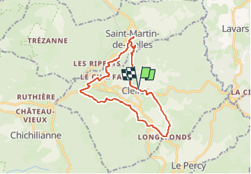
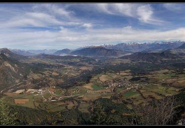
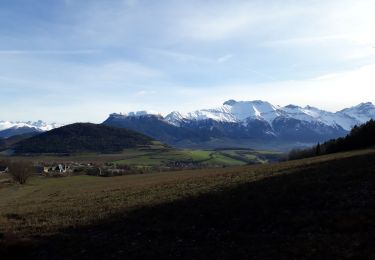
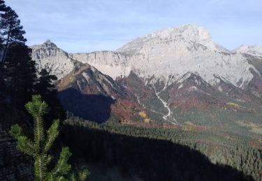
Trail Walking of 14.4 km to be discovered at Auvergne-Rhône-Alpes, Isère, Clelles. This trail is proposed by rapako.

Description

Une balade sympa avec un passage suivant le canal entre Chichilianne et Clelles

Elevation profile

Positioning

Country:
France
Region :
Auvergne-Rhône-Alpes
Department/Province :
Isère
Municipality :
Clelles
Location:
Unknown
Start:(UTM)
707466 ; 4967163 (31T) N.

Trails nearby

Trail Walking Chichilianne - Le Platary - Photo
Walking
patjobou

Walking

Medium
(2)
Chichilianne, Auvergne-Rhône-Alpes, Isère, France
6.6 km | 12.1 km-effort
2h 29min
Yes
Trail Walking Chichilianne - La Fontaine Pourrie - Hauts Plateaux Sud du Vercors - Photo
Walking
tracegps

Walking

Medium
(2)
Chichilianne, Auvergne-Rhône-Alpes, Isère, France
19.4 km | 33 km-effort
7h 45min
Yes
Trail Snowshoes Chichilianne - chichilianne archiane - Photo
Snowshoes
jerome-dupont@laposte.net

Snowshoes

Medium
(1)
Chichilianne, Auvergne-Rhône-Alpes, Isère, France
18.9 km | 32 km-effort
8h 0min
No
Trail Walking Saint-Martin-de-Clelles - Esclops Trièves tour du goutaroux - Photo
Walking
TOULAUDIN

Walking

Medium
Saint-Martin-de-Clelles, Auvergne-Rhône-Alpes, Isère, France
11 km | 18.8 km-effort
4h 58min
Yes
Trail On foot Chichilianne - Pas de l'Aiguille - Photo
On foot
PRO

On foot

Medium
Chichilianne, Auvergne-Rhône-Alpes, Isère, France
17.1 km | 29 km-effort
6h 39min
Yes
Trail On foot Saint-Martin-de-Clelles - Chemin du Goutaroux - Photo
On foot
PRO

On foot

Easy
Saint-Martin-de-Clelles, Auvergne-Rhône-Alpes, Isère, France
4.2 km | 9.5 km-effort
2h 9min
No
Trail Walking Chichilianne - Sommets de Charbonnier & du Platary - Photo
Walking
flip38

Walking

Medium
Chichilianne, Auvergne-Rhône-Alpes, Isère, France
12.1 km | 21 km-effort
5h 24min
Yes
Trail Walking Lavars - Serre de la Fayolle - Photo
Walking
GuyVachet

Walking

Medium
Lavars, Auvergne-Rhône-Alpes, Isère, France
13.3 km | 19.9 km-effort
5h 53min
Yes
Trail Walking Chichilianne - Tete de Praortzel et Crête de Grande Leirie - Photo
Walking
patjobou

Walking

Difficult
Chichilianne, Auvergne-Rhône-Alpes, Isère, France
12.4 km | 21 km-effort
5h 39min
Yes


Close
My subscriptions