fanad route SityTrail > Trails > Outdoor > Ireland > Unknown > County Donegal > Letterkenny SityTrail > Trails > Outdoor > Ireland > Unknown > County Donegal > Letterkenny fanad route ciaranmcelwaine User 3D © OpenStreetMap contributors Length 15.8 km Max alt 92 m Uphill gradient 243 m Km-Effort 19 km Min alt 6 m Downhill gradient 247 m Boucle Yes Creation date : 2014-12-10 00:00:00.0 Updated on : 2014-12-10 00:00:00.0 (0 Reviews) Other activity 4h25 Difficulty : Unknown FREE GPS app for hiking SityTrail IGN / Geographical institutes SityTrail World The world is yours! About Trail Other activity of 15.8 km to be discovered at Unknown, County Donegal, Letterkenny. This trail is proposed by ciaranmcelwaine. Legends | More details (PDF) Elevation profile Legends > 15% 15% - 10% 10% - 5% flat 5% - 10% 10% - 15% 15% - 30% > 30% Photos Points of interest ciaranmcelwaine poi_979448 LETTERKENNY Positioning Country: Ireland Region : Unknown Department/Province : County Donegal Municipality : Letterkenny Location: Fanad North Electoral Division Start:(Dec) 55.252586 / -7.673417 Start:(UTM) 584323 ; 6123702 (29U) N. Comments Please log in to post a review or rate the element Trails nearby ciaranmcelwaine Araheera Bicycle Route Route 1 Cycle Very easy Letterkenny, Unknown, County Donegal, Ireland 
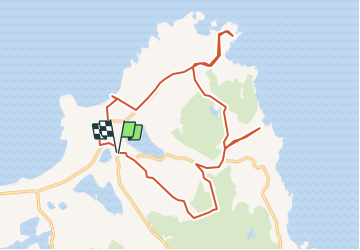
16.2 km | 19.5 km-effort 47min Yes