![](/images/other/stat-length.png)
![Trail Walking Marseille - Gineste Carpiagne G2 3 - Photo](https://media.geolcdn.com/t/1900/400/ext.pjpeg?maxdim=2&url=https%3A%2F%2Fstatic1.geolcdn.com%2Fsiteimages%2Fupload%2Ffiles%2F1553511878bg_sport_marche.png)
Gineste Carpiagne G2 3
Djac
User
![Length](/images/other/stat-length.png)
Length
15.3 km
![Max alt](https://static1.geolcdn.com/siteimages/upload/files/1508320355ic_sort_altitude_max_24dp.png)
Max alt
513 m
![Uphill gradient](https://static1.geolcdn.com/siteimages/upload/files/1508320355ic_sort_den_pos_24dp.png)
Uphill gradient
764 m
![Km-Effort](/images/other/stat-length.png)
Km-Effort
26 km
![Min alt](https://static1.geolcdn.com/siteimages/upload/files/1508320355ic_sort_altitude_min_24dp.png)
Min alt
3 m
![Downhill gradient](https://static1.geolcdn.com/siteimages/upload/files/1508320355ic_sort_den_neg_24dp.png)
Downhill gradient
856 m
![Boucle](https://static1.geolcdn.com/siteimages/upload/files/16400158638029165_repeat_loop_refresh_sync_direction_icon.png)
Boucle
No
Creation date :
2015-03-31 00:00:00.0
Updated on :
2015-03-31 00:00:00.0
![Walking](https://static1.geolcdn.com/sitytour/trail-icons/101.png)
4h55
Difficulty : Difficult
![Scan this QR Code to open this trail in the SityTrail application](https://capi.geolives.com/qq0zvz2zws4bq2lad0pu/sitytour/trails/402189/qr.png?size=200)
FREE GPS app for hiking
About
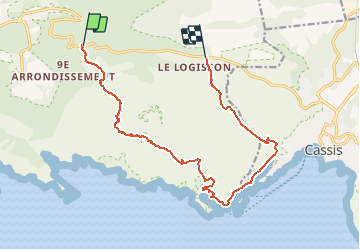
Trail Walking of 15.3 km to be discovered at Provence-Alpes-Côte d'Azur, Bouches-du-Rhône, Marseille. This trail is proposed by Djac.
Description
Parking Col de la Gineste
Col Ricard, Puits du Cancel, Vallon de la Fenêtre,
col de l'Oule,
Vallon d'en Vau, Gouffre Cadeiron,
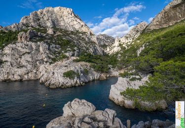
Calanque de Port Miou, grottes,
Pas des Marmots, PA 210,
Col de la Gardiole, Gouffre de Chalabran,
Parking Camp de Carpiagne
Positioning
Country:
France
Region :
Provence-Alpes-Côte d'Azur
Department/Province :
Bouches-du-Rhône
Municipality :
Marseille
Location:
9th Arrondissement
Start:(Dec)
Start:(UTM)
699494 ; 4790431 (31T) N.
Comments
Trails nearby
![Trail Walking Marseille - Luminy: Le chemin du Centaure - Photo](https://media.geolcdn.com/t/375/260/ext.jpg?maxdim=2&url=https%3A%2F%2Fservices.sitytrail.com%2FGeolivesWS%2FDownloadMedia.ashx%3FTrailID%3D179216%26Media%3D20130310112656.jpeg)
![Walking Walking](https://static1.geolcdn.com/sitytour/trail-icons/101.png)
Luminy: Le chemin du Centaure
Walking
Easy
(1)
Marseille,
Provence-Alpes-Côte d'Azur,
Bouches-du-Rhône,
France
![](/images/other/stat-length.png)
8.6 km | 12.5 km-effort
2h 12min
![](https://static1.geolcdn.com/siteimages/upload/files/16400158638029165_repeat_loop_refresh_sync_direction_icon.png)
Yes
![Trail Walking Marseille - luminy calanque sugiton calanque Morgiou - Photo](https://media.geolcdn.com/t/375/260/ext.jpg?maxdim=2&url=https%3A%2F%2Fservices.sitytrail.com%2FGeolivesWS%2FDownloadMedia.ashx%3FTrailID%3D358185%26Media%3Dfix__20141029153035.jpg)
![Walking Walking](https://static1.geolcdn.com/sitytour/trail-icons/101.png)
luminy calanque sugiton calanque Morgiou
Walking
Medium
(1)
Marseille,
Provence-Alpes-Côte d'Azur,
Bouches-du-Rhône,
France
![](/images/other/stat-length.png)
8.7 km | 13.7 km-effort
2h 43min
![](https://static1.geolcdn.com/siteimages/upload/files/16400158638029165_repeat_loop_refresh_sync_direction_icon.png)
Yes
![Trail Walking Marseille - Luminy-Cassis - Photo](https://media.geolcdn.com/t/375/260/ext.jpg?maxdim=2&url=https%3A%2F%2Fservices.sitytrail.com%2FGeolivesWS%2FDownloadMedia.ashx%3FTrailID%3D230309%26Media%3Dfix__20131101131211.jpg)
![Walking Walking](https://static1.geolcdn.com/sitytour/trail-icons/101.png)
Luminy-Cassis
Walking
Medium
(2)
Marseille,
Provence-Alpes-Côte d'Azur,
Bouches-du-Rhône,
France
![](/images/other/stat-length.png)
15.3 km | 25 km-effort
6h 2min
![](https://static1.geolcdn.com/siteimages/upload/files/16400158638029165_repeat_loop_refresh_sync_direction_icon.png)
No
![Trail Walking Marseille - CE calanques morgiou et sugiton - Photo](https://media.geolcdn.com/t/375/260/f27f8a0f-14e3-4522-b1cc-023c0fb4d9dc.jpg&format=jpg&maxdim=2)
![Walking Walking](https://static1.geolcdn.com/sitytour/trail-icons/101.png)
CE calanques morgiou et sugiton
Walking
Medium
(1)
Marseille,
Provence-Alpes-Côte d'Azur,
Bouches-du-Rhône,
France
![](/images/other/stat-length.png)
12.7 km | 19.3 km-effort
6h 33min
![](https://static1.geolcdn.com/siteimages/upload/files/16400158638029165_repeat_loop_refresh_sync_direction_icon.png)
No
![Trail Walking Marseille - Le Col de la Candelle par le couloir du Candelon, depuis le Domaine de Luminy - Photo](https://media.geolcdn.com/t/375/260/ext.jpg?maxdim=2&url=https%3A%2F%2Fservices.sitytrail.com%2FGeolivesWS%2FDownloadMedia.ashx%3FTrailID%3D317414%26Media%3D16640_1.jpg)
![Walking Walking](https://static1.geolcdn.com/sitytour/trail-icons/101.png)
Le Col de la Candelle par le couloir du Candelon, depuis le Domaine de Luminy
Walking
Difficult
(1)
Marseille,
Provence-Alpes-Côte d'Azur,
Bouches-du-Rhône,
France
![](/images/other/stat-length.png)
8.8 km | 15 km-effort
3h 30min
![](https://static1.geolcdn.com/siteimages/upload/files/16400158638029165_repeat_loop_refresh_sync_direction_icon.png)
Yes
![Trail Walking Marseille - Calanques - Aiguille Eissadon - Col Devenson - En vau - Col l'Oule - Photo](https://media.geolcdn.com/t/375/260/ext.jpg?maxdim=2&url=https%3A%2F%2Fstatic1.geolcdn.com%2Fsiteimages%2Fupload%2Ffiles%2F1553511878bg_sport_marche.png)
![Walking Walking](https://static1.geolcdn.com/sitytour/trail-icons/101.png)
Calanques - Aiguille Eissadon - Col Devenson - En vau - Col l'Oule
Walking
Difficult
(2)
Marseille,
Provence-Alpes-Côte d'Azur,
Bouches-du-Rhône,
France
![](/images/other/stat-length.png)
14.6 km | 22 km-effort
4h 48min
![](https://static1.geolcdn.com/siteimages/upload/files/16400158638029165_repeat_loop_refresh_sync_direction_icon.png)
Yes
![Trail Walking Marseille - Le Col de la Candelle par le Pas de l'OEil de Verre - Photo](https://media.geolcdn.com/t/375/260/ext.jpg?maxdim=2&url=https%3A%2F%2Fservices.sitytrail.com%2FGeolivesWS%2FDownloadMedia.ashx%3FTrailID%3D173226%26Media%3D14828_1.jpg)
![Walking Walking](https://static1.geolcdn.com/sitytour/trail-icons/101.png)
Le Col de la Candelle par le Pas de l'OEil de Verre
Walking
Difficult
(1)
Marseille,
Provence-Alpes-Côte d'Azur,
Bouches-du-Rhône,
France
![](/images/other/stat-length.png)
10.6 km | 18.2 km-effort
4h 30min
![](https://static1.geolcdn.com/siteimages/upload/files/16400158638029165_repeat_loop_refresh_sync_direction_icon.png)
Yes
![Trail Walking Marseille - Traversée Morgiou - Sugiton depuis le domaine de Luminy - Photo](https://media.geolcdn.com/t/375/260/ext.jpg?maxdim=2&url=https%3A%2F%2Fservices.sitytrail.com%2FGeolivesWS%2FDownloadMedia.ashx%3FTrailID%3D172954%26Media%3D14433_1.jpg)
![Walking Walking](https://static1.geolcdn.com/sitytour/trail-icons/101.png)
Traversée Morgiou - Sugiton depuis le domaine de Luminy
Walking
Medium
(1)
Marseille,
Provence-Alpes-Côte d'Azur,
Bouches-du-Rhône,
France
![](/images/other/stat-length.png)
7.4 km | 11.6 km-effort
3h 0min
![](https://static1.geolcdn.com/siteimages/upload/files/16400158638029165_repeat_loop_refresh_sync_direction_icon.png)
Yes
![Trail Running Marseille - Luminy - Grand Tour - Photo](https://media.geolcdn.com/t/375/260/ext.jpg?maxdim=2&url=https%3A%2F%2Fservices.sitytrail.com%2FGeolivesWS%2FDownloadMedia.ashx%3FTrailID%3D105036%26Media%3D8596_1.jpg)
![Running Running](https://static1.geolcdn.com/sitytour/trail-icons/103.png)
Luminy - Grand Tour
Running
Medium
(2)
Marseille,
Provence-Alpes-Côte d'Azur,
Bouches-du-Rhône,
France
![](/images/other/stat-length.png)
13.9 km | 19.6 km-effort
1h 34min
![](https://static1.geolcdn.com/siteimages/upload/files/16400158638029165_repeat_loop_refresh_sync_direction_icon.png)
Yes