![](/images/other/stat-length.png)
![Trail Walking Saint-Côme-d'Olt - trail d'aqui départ la Rozière - Photo](https://media.geolcdn.com/t/1900/400/ext.pjpeg?maxdim=2&url=https%3A%2F%2Fstatic1.geolcdn.com%2Fsiteimages%2Fupload%2Ffiles%2F1553511878bg_sport_marche.png)
trail d'aqui départ la Rozière
chantal12
User
![Length](/images/other/stat-length.png)
Length
13.7 km
![Max alt](https://static1.geolcdn.com/siteimages/upload/files/1508320355ic_sort_altitude_max_24dp.png)
Max alt
798 m
![Uphill gradient](https://static1.geolcdn.com/siteimages/upload/files/1508320355ic_sort_den_pos_24dp.png)
Uphill gradient
640 m
![Km-Effort](/images/other/stat-length.png)
Km-Effort
22 km
![Min alt](https://static1.geolcdn.com/siteimages/upload/files/1508320355ic_sort_altitude_min_24dp.png)
Min alt
418 m
![Downhill gradient](https://static1.geolcdn.com/siteimages/upload/files/1508320355ic_sort_den_neg_24dp.png)
Downhill gradient
645 m
![Boucle](https://static1.geolcdn.com/siteimages/upload/files/16400158638029165_repeat_loop_refresh_sync_direction_icon.png)
Boucle
Yes
Creation date :
2024-04-14 11:38:24.547
Updated on :
2024-04-14 16:39:29.709
![Walking](https://static1.geolcdn.com/sitytour/trail-icons/101.png)
4h09
Difficulty : Difficult
![Scan this QR Code to open this trail in the SityTrail application](https://capi.geolives.com/qq0zvz2zws4bq2lad0pu/sitytour/trails/4016591/qr.png?size=200)
FREE GPS app for hiking
About
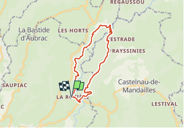
Trail Walking of 13.7 km to be discovered at Occitania, Aveyron, Saint-Côme-d'Olt. This trail is proposed by chantal12.
Description
boucle du trail de st côme d'olt au départ de la ROZIERE .
Suivre balisage trail d'aqui.
Prévoir bonnes chaussures de randonnée .
Dénivelé 640m positif
Positioning
Country:
France
Region :
Occitania
Department/Province :
Aveyron
Municipality :
Saint-Côme-d'Olt
Location:
Unknown
Start:(Dec)
Start:(UTM)
487350 ; 4930893 (31T) N.
Comments
Trails nearby
![Trail Walking Saint-Côme-d'Olt - étape st Jacques st come sur d olt-estaing - Photo](https://media.geolcdn.com/t/375/260/474b24f6-c6fb-4dc7-bd61-3496ab5d9373.jpg&format=jpg&maxdim=2)
![Walking Walking](https://static1.geolcdn.com/sitytour/trail-icons/101.png)
étape st Jacques st come sur d olt-estaing
Walking
Medium
Saint-Côme-d'Olt,
Occitania,
Aveyron,
France
![](/images/other/stat-length.png)
25 km | 32 km-effort
5h 54min
![](https://static1.geolcdn.com/siteimages/upload/files/16400158638029165_repeat_loop_refresh_sync_direction_icon.png)
No
![Trail Walking Saint-Côme-d'Olt - saint Come d'Olt Estaing - Photo](https://media.geolcdn.com/t/375/260/c7fd43f8-31b2-462b-af01-373edc4bd2c8.jpg&format=jpg&maxdim=2)
![Walking Walking](https://static1.geolcdn.com/sitytour/trail-icons/101.png)
saint Come d'Olt Estaing
Walking
Medium
Saint-Côme-d'Olt,
Occitania,
Aveyron,
France
![](/images/other/stat-length.png)
14.5 km | 20 km-effort
5h 54min
![](https://static1.geolcdn.com/siteimages/upload/files/16400158638029165_repeat_loop_refresh_sync_direction_icon.png)
No
![Trail Walking Saint-Côme-d'Olt - saint Côme d'olt- Estaing - Photo](https://media.geolcdn.com/t/375/260/573572db-bc00-4b76-94ac-152ed11426a7.jpg&format=jpg&maxdim=2)
![Walking Walking](https://static1.geolcdn.com/sitytour/trail-icons/101.png)
saint Côme d'olt- Estaing
Walking
Difficult
Saint-Côme-d'Olt,
Occitania,
Aveyron,
France
![](/images/other/stat-length.png)
23 km | 31 km-effort
6h 17min
![](https://static1.geolcdn.com/siteimages/upload/files/16400158638029165_repeat_loop_refresh_sync_direction_icon.png)
No
![Trail Walking Saint-Côme-d'Olt - Saint Côme d'Olt vers Estaing - Photo](https://media.geolcdn.com/t/375/260/ext.jpg?maxdim=2&url=https%3A%2F%2Fservices.sitytrail.com%2FGeolivesWS%2FDownloadMedia.ashx%3FTrailID%3D811193%26Media%3D20170816154701.jpg)
![Walking Walking](https://static1.geolcdn.com/sitytour/trail-icons/101.png)
Saint Côme d'Olt vers Estaing
Walking
Medium
Saint-Côme-d'Olt,
Occitania,
Aveyron,
France
![](/images/other/stat-length.png)
20 km | 28 km-effort
7h 1min
![](https://static1.geolcdn.com/siteimages/upload/files/16400158638029165_repeat_loop_refresh_sync_direction_icon.png)
No
![Trail Walking Saint-Côme-d'Olt - Saint Côme - Espalion - Photo](https://media.geolcdn.com/t/375/260/ext.jpg?maxdim=2&url=https%3A%2F%2Fservices.sitytrail.com%2FGeolivesWS%2FDownloadMedia.ashx%3FTrailID%3D411420%26Media%3Dfix__20150423170544.jpg)
![Walking Walking](https://static1.geolcdn.com/sitytour/trail-icons/101.png)
Saint Côme - Espalion
Walking
Medium
Saint-Côme-d'Olt,
Occitania,
Aveyron,
France
![](/images/other/stat-length.png)
7.1 km | 8.3 km-effort
2h 10min
![](https://static1.geolcdn.com/siteimages/upload/files/16400158638029165_repeat_loop_refresh_sync_direction_icon.png)
No
![Trail Other activity Saint-Côme-d'Olt - ggggfff - Photo](https://media.geolcdn.com/t/375/260/ext.jpg?maxdim=2&url=https%3A%2F%2Fservices.sitytrail.com%2FGeolivesWS%2FDownloadMedia.ashx%3FTrailID%3D190499%26Media%3D20130508172526.jpeg)
![Other activity Other activity](https://static1.geolcdn.com/sitytour/trail-icons/900.png)
ggggfff
Other activity
Very easy
Saint-Côme-d'Olt,
Occitania,
Aveyron,
France
![](/images/other/stat-length.png)
39 km | 68 km-effort
6h 59min
![](https://static1.geolcdn.com/siteimages/upload/files/16400158638029165_repeat_loop_refresh_sync_direction_icon.png)
No
![Trail Cycle Saint-Côme-d'Olt - Sur les traces de la transhumance - St Côme d'Olt - Photo](https://media.geolcdn.com/t/375/260/ext.jpg?maxdim=2&url=https%3A%2F%2Fservices.sitytrail.com%2FGeolivesWS%2FDownloadMedia.ashx%3FTrailID%3D129665%26Media%3D13194_4.jpg)
![Cycle Cycle](https://static1.geolcdn.com/sitytour/trail-icons/200.png)
Sur les traces de la transhumance - St Côme d'Olt
Cycle
Difficult
Saint-Côme-d'Olt,
Occitania,
Aveyron,
France
![](/images/other/stat-length.png)
64 km | 84 km-effort
4h 45min
![](https://static1.geolcdn.com/siteimages/upload/files/16400158638029165_repeat_loop_refresh_sync_direction_icon.png)
Yes
![Trail Walking Espalion - Flaujac - Abbaye de Bonneval - Photo](https://media.geolcdn.com/t/375/260/ext.jpg?maxdim=2&url=https%3A%2F%2Fservices.sitytrail.com%2FGeolivesWS%2FDownloadMedia.ashx%3FTrailID%3D103929%26Media%3D6791_6.jpg)
![Walking Walking](https://static1.geolcdn.com/sitytour/trail-icons/101.png)
Flaujac - Abbaye de Bonneval
Walking
Difficult
(1)
Espalion,
Occitania,
Aveyron,
France
![](/images/other/stat-length.png)
13.3 km | 19.6 km-effort
4h 0min
![](https://static1.geolcdn.com/siteimages/upload/files/16400158638029165_repeat_loop_refresh_sync_direction_icon.png)
Yes
![Trail sport Saint-Côme-d'Olt - Saint-Jacques, 2024, étape trois - Photo](https://media.geolcdn.com/t/375/260/93d4c0ff-c5aa-4b74-9acb-858988226620.jpg&format=jpg&maxdim=2)
Saint-Jacques, 2024, étape trois
sport
Very easy
Saint-Côme-d'Olt,
Occitania,
Aveyron,
France
![](/images/other/stat-length.png)
24 km | 31 km-effort
Unknown
![](https://static1.geolcdn.com/siteimages/upload/files/16400158638029165_repeat_loop_refresh_sync_direction_icon.png)
No