Trail Walking Thièvres - THIEVRES - Circuit de l'arbre de Cocagne - Photo

THIEVRES - Circuit de l'arbre de Cocagne

© OpenStreetMap contributors
Length
Length
8.8 km
Max alt
Max alt
149 m
Uphill gradient
Uphill gradient
140 m
Km-Effort
Km-Effort  
10.6 km
Min alt
Min alt
74 m
Downhill gradient
Downhill gradient
139 m
Boucle
Boucle
Yes
Creation date :
2024-04-11 12:47:44.756
Updated on :
2024-04-11 13:00:28.106

(0 Reviews)

Walking
Walking
2h24
Difficulty : Medium

Scan this QR Code to open this trail in the SityTrail application

FREE GPS app for hiking

Logo SityTrail SityTrail

IGN / Geographical institutes

Download SityTrail from the App Store Download SityTrail from Google Play

Logo SityTrail SityTrail World

The world is yours!

Download SityTrail from the App Store Download SityTrail from Google Play Download SityTrail on Huawei AppGallery

About

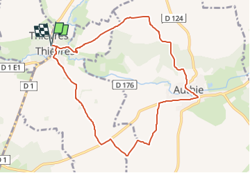
Trail Walking of 8.8 km to be discovered at Hauts-de-France, Pas-de-Calais, Thièvres. This trail is proposed by temmichel.

Description

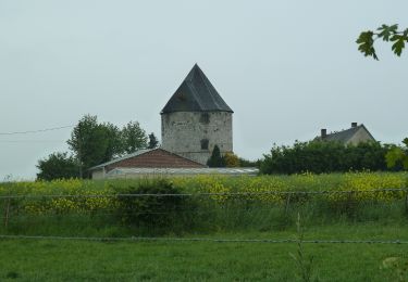
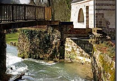
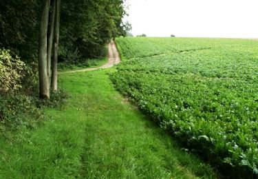
Randonnée qui vous conduira de part et d'autre de l'Authies en parcourant le GR 124 A titre d'information le GR 124 débute à CIRE LES MELO dans l'Oise et rejoint le GR 121 à REBREUVIETTE dans le Pas-de-Calais pour une longueur de 222 kms
Bonne randonnée
Jean-Michel

Elevation profile

Photos

Positioning

Country:
France
Region :
Hauts-de-France
Department/Province :
Pas-de-Calais
Municipality :
Thièvres
Location:
Unknown
Start:(UTM)
460999 ; 5553076 (31U) N.

Trails nearby

Trail On foot Vauchelles-lès-Authie - Circuit du Pigeonnier au Moulin - Photo
On foot
GUIDE+

On foot

Easy
Vauchelles-lès-Authie, Hauts-de-France, Somme, France
6.8 km | 7.7 km-effort
1h 44min
Yes
Trail On foot Authie - Autour du Prieuré d'Authie - Photo
On foot
GUIDE+

On foot

Easy
Authie, Hauts-de-France, Somme, France
10 km | 11.8 km-effort
2h 41min
Yes
Trail Walking Thièvres - Sentier de la montagne - Thièvres - Photo
Walking
tracegps

Walking

Medium
Thièvres, Hauts-de-France, Somme, France
8.7 km | 10.1 km-effort
2h 10min
Yes
Trail Walking Thièvres - Sentier du Fay - Grand-Rullecourt - Photo
Walking
tracegps

Walking

Very difficult
Thièvres, Hauts-de-France, Somme, France
8.7 km | 10.1 km-effort
4h 25min
Yes
Trail Walking Pas-en-Artois - Sentier des Bois - Pas-en-Artois - Photo
Walking
tracegps

Walking

Medium
Pas-en-Artois, Hauts-de-France, Pas-de-Calais, France
8.7 km | 10.7 km-effort
2h 10min
Yes
Trail Walking Beauquesne - Le Tortillard (variante courte) - Photo
Walking
tracegps

Walking

Medium
Beauquesne, Hauts-de-France, Somme, France
8.7 km | 9.7 km-effort
2h 30min
Yes
Trail Walking Authie - Autour du Prieuré d'Authie - Photo
Walking
tracegps

Walking

Medium
(1)
Authie, Hauts-de-France, Somme, France
10.1 km | 12 km-effort
3h 19min
Yes
Trail Walking Beauquesne - Le Tortillard - Photo
Walking
tracegps

Walking

Medium
Beauquesne, Hauts-de-France, Somme, France
11.7 km | 13.2 km-effort
4h 0min
Yes
Trail Walking Thièvres - kjv - Photo
Walking
a.catteau

Walking

Very easy
Thièvres, Hauts-de-France, Somme, France
9 km | 10.4 km-effort
2h 39min
Yes


Close
My subscriptions