![](/images/other/stat-length.png)
![Trail Walking Figeac - J8_Figeac - La Chapelle Marival (Voie de Rocamadour) - Photo](https://media.geolcdn.com/t/1900/400/ext.pjpeg?maxdim=2&url=https%3A%2F%2Fstatic1.geolcdn.com%2Fsiteimages%2Fupload%2Ffiles%2F1553511878bg_sport_marche.png)
J8_Figeac - La Chapelle Marival (Voie de Rocamadour)
MAD-CVW
User
![Length](/images/other/stat-length.png)
Length
24 km
![Max alt](https://static1.geolcdn.com/siteimages/upload/files/1508320355ic_sort_altitude_max_24dp.png)
Max alt
555 m
![Uphill gradient](https://static1.geolcdn.com/siteimages/upload/files/1508320355ic_sort_den_pos_24dp.png)
Uphill gradient
679 m
![Km-Effort](/images/other/stat-length.png)
Km-Effort
33 km
![Min alt](https://static1.geolcdn.com/siteimages/upload/files/1508320355ic_sort_altitude_min_24dp.png)
Min alt
198 m
![Downhill gradient](https://static1.geolcdn.com/siteimages/upload/files/1508320355ic_sort_den_neg_24dp.png)
Downhill gradient
491 m
![Boucle](https://static1.geolcdn.com/siteimages/upload/files/16400158638029165_repeat_loop_refresh_sync_direction_icon.png)
Boucle
No
Creation date :
2024-04-10 07:32:56.398
Updated on :
2024-05-18 20:38:00.607
![Walking](https://static1.geolcdn.com/sitytour/trail-icons/101.png)
7h26
Difficulty : Very difficult
![Scan this QR Code to open this trail in the SityTrail application](https://capi.geolives.com/qq0zvz2zws4bq2lad0pu/sitytour/trails/4012025/qr.png?size=200)
FREE GPS app for hiking
About
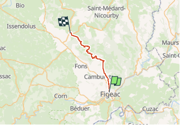
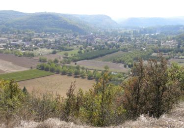
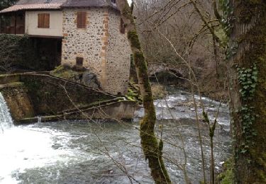
Trail Walking of 24 km to be discovered at Occitania, Lot, Figeac. This trail is proposed by MAD-CVW.
Description
Au départ de Figeac, à l'église suivre le GR6 vers Gramat.
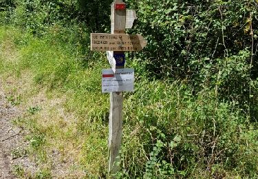
Au niveau de Doulans, prendre le sentier balisé à droite avant d'entrer dans le village pour éviter la route. Très beau parcours à travers la montagne par le Pech Rouxou jusqu'à Cardaillac.
Positioning
Country:
France
Region :
Occitania
Department/Province :
Lot
Municipality :
Figeac
Location:
Unknown
Start:(Dec)
Start:(UTM)
423067 ; 4940462 (31T) N.
Comments
Trails nearby
![Trail Walking Figeac - Compostelle 2: 1-Figeac - Espagnac - Photo](https://media.geolcdn.com/t/375/260/ext.jpg?maxdim=2&url=https%3A%2F%2Fservices.sitytrail.com%2FGeolivesWS%2FDownloadMedia.ashx%3FTrailID%3D606459%26Media%3Dfix__20160723135745.jpg)
![Walking Walking](https://static1.geolcdn.com/sitytour/trail-icons/101.png)
Compostelle 2: 1-Figeac - Espagnac
Walking
Medium
(1)
Figeac,
Occitania,
Lot,
France
![](/images/other/stat-length.png)
27 km | 34 km-effort
6h 35min
![](https://static1.geolcdn.com/siteimages/upload/files/16400158638029165_repeat_loop_refresh_sync_direction_icon.png)
No
![Trail Walking Figeac - Etape13 Figeac a Carjac - Photo](https://media.geolcdn.com/t/375/260/efd60137-13f6-40d5-b090-132567a61345.jpg&format=jpg&maxdim=2)
![Walking Walking](https://static1.geolcdn.com/sitytour/trail-icons/101.png)
Etape13 Figeac a Carjac
Walking
Difficult
Figeac,
Occitania,
Lot,
France
![](/images/other/stat-length.png)
32 km | 42 km-effort
7h 40min
![](https://static1.geolcdn.com/siteimages/upload/files/16400158638029165_repeat_loop_refresh_sync_direction_icon.png)
No
![Walking Walking](https://static1.geolcdn.com/sitytour/trail-icons/101.png)
CC_Velay_CC_12_Figeac_Cajarc_20071103
Walking
Medium
(1)
Figeac,
Occitania,
Lot,
France
![](/images/other/stat-length.png)
30 km | 39 km-effort
7h 0min
![](https://static1.geolcdn.com/siteimages/upload/files/16400158638029165_repeat_loop_refresh_sync_direction_icon.png)
No
![Trail Walking Faycelles - Mon Compostelle sixième étape - Photo](https://media.geolcdn.com/t/375/260/ext.jpg?maxdim=2&url=https%3A%2F%2Fservices.sitytrail.com%2FGeolivesWS%2FDownloadMedia.ashx%3FTrailID%3D682900%26Media%3D54ab3826-f9fa-4a63-b904-0665847fae64.JPG)
![Walking Walking](https://static1.geolcdn.com/sitytour/trail-icons/101.png)
Mon Compostelle sixième étape
Walking
Difficult
Faycelles,
Occitania,
Lot,
France
![](/images/other/stat-length.png)
43 km | 55 km-effort
9h 40min
![](https://static1.geolcdn.com/siteimages/upload/files/16400158638029165_repeat_loop_refresh_sync_direction_icon.png)
No
![Trail Equestrian Lissac-et-Mouret - La Cazelle-Camburat-Mouret-La Cazelle - Photo](https://media.geolcdn.com/t/375/260/ext.jpg?maxdim=2&url=https%3A%2F%2Fstatic1.geolcdn.com%2Fsiteimages%2Fupload%2Ffiles%2F1524743154cheval.jpg)
![Equestrian Equestrian](https://static1.geolcdn.com/sitytour/trail-icons/300.png)
La Cazelle-Camburat-Mouret-La Cazelle
Equestrian
Easy
(1)
Lissac-et-Mouret,
Occitania,
Lot,
France
![](/images/other/stat-length.png)
13.9 km | 17.5 km-effort
2h 43min
![](https://static1.geolcdn.com/siteimages/upload/files/16400158638029165_repeat_loop_refresh_sync_direction_icon.png)
Yes
![Trail Mountain bike Capdenac-Gare - capdenac - Photo](https://media.geolcdn.com/t/375/260/ext.jpg?maxdim=2&url=https%3A%2F%2Fservices.sitytrail.com%2FGeolivesWS%2FDownloadMedia.ashx%3FTrailID%3D183699%26Media%3D20130323121202.jpg)
![Mountain bike Mountain bike](https://static1.geolcdn.com/sitytour/trail-icons/202.png)
capdenac
Mountain bike
Medium
(1)
Capdenac-Gare,
Occitania,
Aveyron,
France
![](/images/other/stat-length.png)
34 km | 45 km-effort
4h 13min
![](https://static1.geolcdn.com/siteimages/upload/files/16400158638029165_repeat_loop_refresh_sync_direction_icon.png)
Yes
![Trail sport Figeac - 20240418 Figeac (hôtel les Bains)-Rian (les ânes du Célé) - Photo](https://media.geolcdn.com/t/375/260/1e2c3c3a-2cb9-4aa8-8a80-efa83001be61.jpg&format=jpg&maxdim=2)
20240418 Figeac (hôtel les Bains)-Rian (les ânes du Célé)
sport
Very easy
Figeac,
Occitania,
Lot,
France
![](/images/other/stat-length.png)
24 km | 31 km-effort
Unknown
![](https://static1.geolcdn.com/siteimages/upload/files/16400158638029165_repeat_loop_refresh_sync_direction_icon.png)
No
![Trail Mountain bike Faycelles - figeac cassagnole st cirq la popie - Photo](https://media.geolcdn.com/t/375/260/dec37c16-3b87-4c7b-bf34-266ba0f94195.jpg&format=jpg&maxdim=2)
![Mountain bike Mountain bike](https://static1.geolcdn.com/sitytour/trail-icons/202.png)
figeac cassagnole st cirq la popie
Mountain bike
Medium
Faycelles,
Occitania,
Lot,
France
![](/images/other/stat-length.png)
68 km | 89 km-effort
9h 21min
![](https://static1.geolcdn.com/siteimages/upload/files/16400158638029165_repeat_loop_refresh_sync_direction_icon.png)
No
![Trail Walking Figeac - Figeac - Corn - Chemin de St-Jacques de Compostelle - Photo](https://media.geolcdn.com/t/375/260/ext.jpg?maxdim=2&url=https%3A%2F%2Fservices.sitytrail.com%2FGeolivesWS%2FDownloadMedia.ashx%3FTrailID%3D108749%26Media%3D1844_2.jpg)
![Walking Walking](https://static1.geolcdn.com/sitytour/trail-icons/101.png)
Figeac - Corn - Chemin de St-Jacques de Compostelle
Walking
Difficult
Figeac,
Occitania,
Lot,
France
![](/images/other/stat-length.png)
18.4 km | 23 km-effort
3h 0min
![](https://static1.geolcdn.com/siteimages/upload/files/16400158638029165_repeat_loop_refresh_sync_direction_icon.png)
No