Trail Walking Conamara Municipal District - Début rando des Twelve Bens - Photo
 Lobin
Lobin

User

© OpenStreetMap contributors
Length
Length
4.1 km
Max alt
Max alt
248 m
Uphill gradient
Uphill gradient
210 m
Km-Effort
Km-Effort  
6.9 km
Min alt
Min alt
25 m
Downhill gradient
Downhill gradient
211 m
Boucle
Boucle
Yes
Creation date :
2024-04-05 12:12:03.0
Updated on :
2024-04-05 15:59:33.542

(0 Reviews)

Walking
Walking
1h28
Difficulty : Difficult

Scan this QR Code to open this trail in the SityTrail application

FREE GPS app for hiking

Logo SityTrail SityTrail

IGN / Geographical institutes

Download SityTrail from the App Store Download SityTrail from Google Play

Logo SityTrail SityTrail World

The world is yours!

Download SityTrail from the App Store Download SityTrail from Google Play Download SityTrail on Huawei AppGallery

About

Trail Walking of 4.1 km to be discovered at Unknown, County Galway, Conamara Municipal District. This trail is proposed by Lobin.

Elevation profile

Photos

Positioning

Country:
Ireland
Region :
Unknown
Department/Province :
County Galway
Municipality :
Conamara Municipal District
Location:
Bencorr Electoral Division
Start:(UTM)
446449 ; 5925267 (29U) N.

Trails nearby

Trail Walking Conamara Municipal District - Glencoaghan Horseshoe - Photo
Walking
heb

Walking

Difficult
Conamara Municipal District, Unknown, County Galway, Ireland
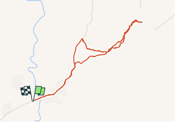
13.7 km | 33 km-effort
6h 21min
No


Close
My subscriptions