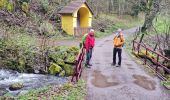

Rando Marcheurs..04/04_2025

boubou68
User

Length
21 km

Max alt
1019 m

Uphill gradient
1024 m

Km-Effort
35 km

Min alt
406 m

Downhill gradient
1024 m
Boucle
Yes
Creation date :
2024-04-04 07:09:47.5
Updated on :
2024-04-04 13:42:50.609
4h42
Difficulty : Very difficult

FREE GPS app for hiking
About
Trail Walking of 21 km to be discovered at Grand Est, Haut-Rhin, Soultz-Haut-Rhin. This trail is proposed by boubou68.
Description
Belle petite Rando sportive avec Alain et Hubi...Petite pluie vers 11H..
pluie torrentielle et vent pendant la pause repas dans l'Abri' au Col du Judenhutte
Descente ensoleillée...Contents de notre journée.
A bientôt les amis.
Positioning
Country:
France
Region :
Grand Est
Department/Province :
Haut-Rhin
Municipality :
Soultz-Haut-Rhin
Location:
Unknown
Start:(Dec)
Start:(UTM)
362666 ; 5307489 (32T) N.
Comments
Trails nearby
Le Markstein


Walking
Difficult
(1)
Lautenbachzell,
Grand Est,
Haut-Rhin,
France

22 km | 35 km-effort
6h 0min
Yes
Firstacker - Willer sur Thur


On foot
Easy
Goldbach-Altenbach,
Grand Est,
Haut-Rhin,
France

7.4 km | 9.6 km-effort
2h 11min
No
AMAELLES - Rando 06/01/2025 - Bulh


Walking
Medium
Buhl,
Grand Est,
Haut-Rhin,
France

5.4 km | 8.3 km-effort
1h 53min
Yes
Rando du 01/08/2024


Walking
Very difficult
Murbach,
Grand Est,
Haut-Rhin,
France

18.9 km | 30 km-effort
5h 53min
Yes
Rando Retrouvailles...01/03/2024.par Jean Marc


Walking
Very difficult
Jungholtz,
Grand Est,
Haut-Rhin,
France

11.3 km | 19.2 km-effort
1h 35min
Yes

TL 11/23 avec un petit tour dans le vignoble avec départ du parking Côte de l...


Walking
Medium
(1)
Buhl,
Grand Est,
Haut-Rhin,
France

8.7 km | 12 km-effort
2h 43min
Yes
Mon tour des Vosges (4 jours)


Walking
Very difficult
Soultz-Haut-Rhin,
Grand Est,
Haut-Rhin,
France

71 km | 113 km-effort
25h 38min
Yes
La " Jean Marc du jour 24/06_2023


Walking
Very difficult
Murbach,
Grand Est,
Haut-Rhin,
France

14.7 km | 28 km-effort
4h 3min
Yes


 SityTrail


