![](/images/other/stat-length.png)
![Trail Walking Luxembourg - Itinérant Luxembourg Jour 1 : Visite de Luxembourg Ville - Photo](https://media.geolcdn.com/t/1900/400/ext.pjpeg?maxdim=2&url=https%3A%2F%2Fmedia.geolcdn.com%2Ff%2F35d80b54-5540-4eaf-ab66-fd3323c5eeb0.jpg)
Itinérant Luxembourg Jour 1 : Visite de Luxembourg Ville
chessyca
User
![Length](/images/other/stat-length.png)
Length
15.6 km
![Max alt](https://static1.geolcdn.com/siteimages/upload/files/1508320355ic_sort_altitude_max_24dp.png)
Max alt
327 m
![Uphill gradient](https://static1.geolcdn.com/siteimages/upload/files/1508320355ic_sort_den_pos_24dp.png)
Uphill gradient
437 m
![Km-Effort](/images/other/stat-length.png)
Km-Effort
21 km
![Min alt](https://static1.geolcdn.com/siteimages/upload/files/1508320355ic_sort_altitude_min_24dp.png)
Min alt
239 m
![Downhill gradient](https://static1.geolcdn.com/siteimages/upload/files/1508320355ic_sort_den_neg_24dp.png)
Downhill gradient
432 m
![Boucle](https://static1.geolcdn.com/siteimages/upload/files/16400158638029165_repeat_loop_refresh_sync_direction_icon.png)
Boucle
Yes
Creation date :
2024-04-02 10:33:30.403
Updated on :
2024-04-10 21:24:31.296
![Walking](https://static1.geolcdn.com/sitytour/trail-icons/101.png)
3h45
Difficulty : Easy
![Scan this QR Code to open this trail in the SityTrail application](https://capi.geolives.com/qq0zvz2zws4bq2lad0pu/sitytour/trails/4002188/qr.png?size=200)
FREE GPS app for hiking
About
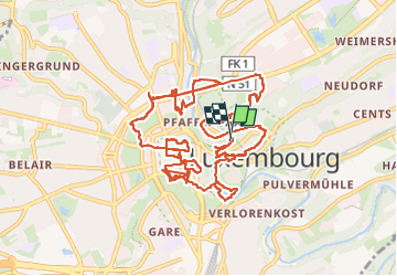
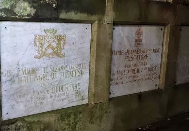
Trail Walking of 15.6 km to be discovered at Unknown, Canton Luxembourg, Luxembourg. This trail is proposed by chessyca.
Description
Découverte ou redécouverte des principaux lieux touristiques de la ville
Petit tour en Tram et funiculaire (retirer environ 3 km du trajet vers le quartier europe)
Hébergement hotel de jeunesse Luxembourg Ville
Positioning
Country:
Luxembourg
Region :
Unknown
Department/Province :
Canton Luxembourg
Municipality :
Luxembourg
Location:
Pfaffenthal
Start:(Dec)
Start:(UTM)
293253 ; 5499536 (32U) N.
Comments
Trails nearby
![Trail On foot Luxembourg - Maple leaf - Photo](https://media.geolcdn.com/t/375/260/ext.jpg?maxdim=2&url=https%3A%2F%2Fmedia.geolcdn.com%2Ff%2Fa23d593d-2772-4b4d-9b30-c01313559189.jpeg)
![On foot On foot](https://static1.geolcdn.com/sitytour/trail-icons/100.png)
Maple leaf
On foot
Easy
Luxembourg,
Unknown,
Canton Luxembourg,
Luxembourg
![](/images/other/stat-length.png)
4.7 km | 6 km-effort
1h 21min
![](https://static1.geolcdn.com/siteimages/upload/files/16400158638029165_repeat_loop_refresh_sync_direction_icon.png)
Yes
![Trail On foot Walferdange - Auto-Pédestre Bereldange - Photo](https://media.geolcdn.com/t/375/260/ext.jpg?maxdim=2&url=https%3A%2F%2Fmedia.geolcdn.com%2Ff%2F9ffb96c9-8ee3-4baa-8f73-3ae3b0006373.jpeg)
![On foot On foot](https://static1.geolcdn.com/sitytour/trail-icons/100.png)
Auto-Pédestre Bereldange
On foot
Easy
Walferdange,
Unknown,
Canton Luxembourg,
Luxembourg
![](/images/other/stat-length.png)
6.5 km | 9 km-effort
2h 2min
![](https://static1.geolcdn.com/siteimages/upload/files/16400158638029165_repeat_loop_refresh_sync_direction_icon.png)
Yes
![Trail On foot Leudelange - Auto-Pédestre Roedgen - Photo](https://media.geolcdn.com/t/375/260/ext.jpg?maxdim=2&url=https%3A%2F%2Fmedia.geolcdn.com%2Ff%2F4387dfb8-6c80-4acc-9a37-ef44c95f5b0e.jpeg)
![On foot On foot](https://static1.geolcdn.com/sitytour/trail-icons/100.png)
Auto-Pédestre Roedgen
On foot
Easy
Leudelange,
Unknown,
Canton Esch-sur-Alzette,
Luxembourg
![](/images/other/stat-length.png)
9.7 km | 11.9 km-effort
2h 42min
![](https://static1.geolcdn.com/siteimages/upload/files/16400158638029165_repeat_loop_refresh_sync_direction_icon.png)
Yes
![Trail On foot Luxembourg - Sentier pédestre Hibou - Photo](https://media.geolcdn.com/t/375/260/ext.jpg?maxdim=2&url=https%3A%2F%2Fmedia.geolcdn.com%2Ff%2Fb315718c-907d-46e0-8a6a-fbd567016707.jpeg)
![On foot On foot](https://static1.geolcdn.com/sitytour/trail-icons/100.png)
Sentier pédestre Hibou
On foot
Easy
Luxembourg,
Unknown,
Canton Luxembourg,
Luxembourg
![](/images/other/stat-length.png)
7.7 km | 9.9 km-effort
2h 14min
![](https://static1.geolcdn.com/siteimages/upload/files/16400158638029165_repeat_loop_refresh_sync_direction_icon.png)
Yes
![Trail On foot Luxembourg - Parcours de cross - Photo](https://media.geolcdn.com/t/375/260/ext.jpg?maxdim=2&url=https%3A%2F%2Fmedia.geolcdn.com%2Ff%2Fe3e160d8-098a-430f-a621-d8ccdea5d783.jpeg)
![On foot On foot](https://static1.geolcdn.com/sitytour/trail-icons/100.png)
Parcours de cross
On foot
Easy
Luxembourg,
Unknown,
Canton Luxembourg,
Luxembourg
![](/images/other/stat-length.png)
4.9 km | 6.3 km-effort
1h 26min
![](https://static1.geolcdn.com/siteimages/upload/files/16400158638029165_repeat_loop_refresh_sync_direction_icon.png)
Yes
![Trail Walking Hesperange - Autopedestres : Hesperange - Photo](https://media.geolcdn.com/t/375/260/ext.jpg?maxdim=2&url=https%3A%2F%2Fstatic1.geolcdn.com%2Fsiteimages%2Fupload%2Ffiles%2F1553511878bg_sport_marche.png)
![Walking Walking](https://static1.geolcdn.com/sitytour/trail-icons/101.png)
Autopedestres : Hesperange
Walking
Very easy
(1)
Hesperange,
Unknown,
Canton Luxembourg,
Luxembourg
![](/images/other/stat-length.png)
4.9 km | 6.2 km-effort
Unknown
![](https://static1.geolcdn.com/siteimages/upload/files/16400158638029165_repeat_loop_refresh_sync_direction_icon.png)
Yes
![Trail Nordic walking Bertrange - Bertrange - Marche nordique - Photo](https://media.geolcdn.com/t/375/260/ext.jpg?maxdim=2&url=https%3A%2F%2Fmedia.geolcdn.com%2Ff%2Fee874a90-ed77-49cf-89e5-adfa877000e4.HEIC)
![Nordic walking Nordic walking](https://static1.geolcdn.com/sitytour/trail-icons/102.png)
Bertrange - Marche nordique
Nordic walking
Very easy
Bertrange,
Unknown,
Canton Luxembourg,
Luxembourg
![](/images/other/stat-length.png)
15.9 km | 18.1 km-effort
Unknown
![](https://static1.geolcdn.com/siteimages/upload/files/16400158638029165_repeat_loop_refresh_sync_direction_icon.png)
No
![Trail On foot Hesperange - Sentier Naturel autour de Dupont - Photo](https://media.geolcdn.com/t/375/260/ext.jpg?maxdim=2&url=https%3A%2F%2Fmedia.geolcdn.com%2Ff%2Fcb2d487a-93ce-469b-9ded-5420f82a3cee.jpeg)
![On foot On foot](https://static1.geolcdn.com/sitytour/trail-icons/100.png)
Sentier Naturel autour de Dupont
On foot
Easy
Hesperange,
Unknown,
Canton Luxembourg,
Luxembourg
![](/images/other/stat-length.png)
4 km | 4.9 km-effort
1h 6min
![](https://static1.geolcdn.com/siteimages/upload/files/16400158638029165_repeat_loop_refresh_sync_direction_icon.png)
Yes
![Trail On foot Hesperange - Fleche Bleu Itzig - Photo](https://media.geolcdn.com/t/375/260/ext.jpg?maxdim=2&url=https%3A%2F%2Fmedia.geolcdn.com%2Ff%2F27fd8cdd-3072-452f-936e-8661113f01e6.jpeg)
![On foot On foot](https://static1.geolcdn.com/sitytour/trail-icons/100.png)
Fleche Bleu Itzig
On foot
Easy
Hesperange,
Unknown,
Canton Luxembourg,
Luxembourg
![](/images/other/stat-length.png)
8.3 km | 10.7 km-effort
2h 26min
![](https://static1.geolcdn.com/siteimages/upload/files/16400158638029165_repeat_loop_refresh_sync_direction_icon.png)
Yes