Trail Walking Rochefort-Samson - Vercors ouest Rochefort Samson - Photo

Vercors ouest Rochefort Samson

© OpenStreetMap contributors
Length
Length
13.9 km
Max alt
Max alt
879 m
Uphill gradient
Uphill gradient
736 m
Km-Effort
Km-Effort  
24 km
Min alt
Min alt
441 m
Downhill gradient
Downhill gradient
735 m
Boucle
Boucle
Yes
Creation date :
2024-04-02 07:12:39.418
Updated on :
2024-04-02 13:51:19.22

(0 Reviews)

Walking
Walking
4h22
Difficulty : Very difficult

Scan this QR Code to open this trail in the SityTrail application

FREE GPS app for hiking

Logo SityTrail SityTrail

IGN / Geographical institutes

Download SityTrail from the App Store Download SityTrail from Google Play

Logo SityTrail SityTrail World

The world is yours!

Download SityTrail from the App Store Download SityTrail from Google Play Download SityTrail on Huawei AppGallery

About

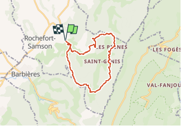
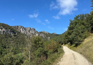
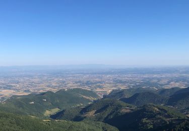
Trail Walking of 13.9 km to be discovered at Auvergne-Rhône-Alpes, Drôme, Rochefort-Samson. This trail is proposed by Catherine de Brunoy.

Description

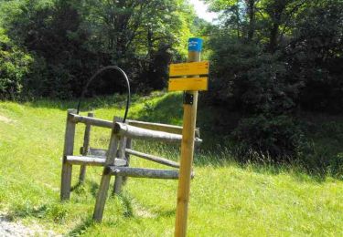
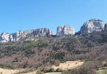
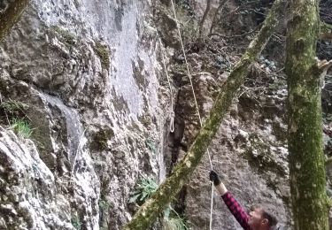
Combe d'oyans, falaise de Musan, Pas du loup. Très beaux panoramas. Des montées mais assez douces

Elevation profile

Positioning

Country:
France
Region :
Auvergne-Rhône-Alpes
Department/Province :
Drôme
Municipality :
Rochefort-Samson
Location:
Unknown
Start:(UTM)
670949 ; 4982164 (31T) N.

Trails nearby

Trail Walking Beauregard-Baret - Pré de Cinq Sous - Beauregard Baret - Photo
Walking
tracegps

Walking

Medium
(1)
Beauregard-Baret, Auvergne-Rhône-Alpes, Drôme, France
11.6 km | 23 km-effort
5h 0min
Yes
Trail Walking Rochefort-Samson - Les Vachères - Combe d'oyans  - Photo
Walking
randochu

Walking

Difficult
(1)
Rochefort-Samson, Auvergne-Rhône-Alpes, Drôme, France
17.1 km | 28 km-effort
8h 26min
Yes
Trail Walking Saint-Vincent-la-Commanderie - 26 st Vincent commanderie zel - Photo
Walking
GUIDE
randodyssée

Walking

Easy
Saint-Vincent-la-Commanderie, Auvergne-Rhône-Alpes, Drôme, France
14.2 km | 22 km-effort
6h 5min
Yes
Trail Walking Beauregard-Baret - croix st Gervais et Pas du loup - Photo
Walking
GUIDE
nadd73

Walking

Medium
Beauregard-Baret, Auvergne-Rhône-Alpes, Drôme, France
10 km | 16.9 km-effort
5h 4min
No
Trail Walking Chatuzange-le-Goubet - autour de Papelissier - Photo
Walking
ajd26

Walking

Very easy
(1)
Chatuzange-le-Goubet, Auvergne-Rhône-Alpes, Drôme, France
16.5 km | 21 km-effort
3h 20min
Yes
Trail Walking Barbières - Traversée Barbières Beauregard-Baret - Photo
Walking
GuyVachet

Walking

Very difficult
Barbières, Auvergne-Rhône-Alpes, Drôme, France
17 km | 28 km-effort
7h 9min
No
Trail Walking Barbières - Barbière Pierre Chauve  - Photo
Walking
alinetpierre

Walking

Medium
Barbières, Auvergne-Rhône-Alpes, Drôme, France
8.1 km | 15.5 km-effort
2h 25min
Yes
Trail Walking Barbières - Barbières - Source Barberolle - Photo
Walking
Philindy26

Walking

Difficult
(1)
Barbières, Auvergne-Rhône-Alpes, Drôme, France
14.8 km | 23 km-effort
4h 0min
Yes
Trail Walking Beauregard-Baret - Pré de cinq sous - Photo
Walking
cousam

Walking

Medium
Beauregard-Baret, Auvergne-Rhône-Alpes, Drôme, France
8.8 km | 17.4 km-effort
3h 14min
Yes


Close
My subscriptions