![](/images/other/stat-length.png)
![Trail Walking Chanos-Curson - 26 - collines de Chanos-Curson - Photo](https://media.geolcdn.com/t/1900/400/ext.pjpeg?maxdim=2&url=https%3A%2F%2Fstatic1.geolcdn.com%2Fsiteimages%2Fupload%2Ffiles%2F1553511878bg_sport_marche.png)
26 - collines de Chanos-Curson
guilmanu
User
![Length](/images/other/stat-length.png)
Length
10.2 km
![Max alt](https://static1.geolcdn.com/siteimages/upload/files/1508320355ic_sort_altitude_max_24dp.png)
Max alt
260 m
![Uphill gradient](https://static1.geolcdn.com/siteimages/upload/files/1508320355ic_sort_den_pos_24dp.png)
Uphill gradient
233 m
![Km-Effort](/images/other/stat-length.png)
Km-Effort
13.3 km
![Min alt](https://static1.geolcdn.com/siteimages/upload/files/1508320355ic_sort_altitude_min_24dp.png)
Min alt
155 m
![Downhill gradient](https://static1.geolcdn.com/siteimages/upload/files/1508320355ic_sort_den_neg_24dp.png)
Downhill gradient
234 m
![Boucle](https://static1.geolcdn.com/siteimages/upload/files/16400158638029165_repeat_loop_refresh_sync_direction_icon.png)
Boucle
Yes
Creation date :
2024-04-01 11:33:28.572
Updated on :
2024-04-01 19:25:15.011
![Walking](https://static1.geolcdn.com/sitytour/trail-icons/101.png)
2h16
Difficulty : Medium
![Scan this QR Code to open this trail in the SityTrail application](https://capi.geolives.com/qq0zvz2zws4bq2lad0pu/sitytour/trails/4001020/qr.png?size=200)
FREE GPS app for hiking
About
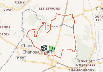
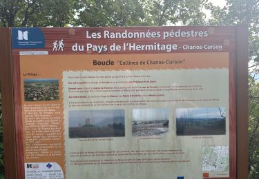
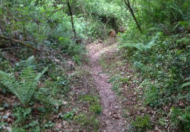
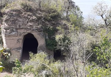
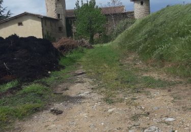
Trail Walking of 10.2 km to be discovered at Auvergne-Rhône-Alpes, Drôme, Chanos-Curson. This trail is proposed by guilmanu.
Description
Description de l'itinéraire ici :
https://rando-ardeche-hermitage.fr/?categories=T1&categories=T2&categories=T4&categories=T7&categories=T8
Positioning
Country:
France
Region :
Auvergne-Rhône-Alpes
Department/Province :
Drôme
Municipality :
Chanos-Curson
Location:
Unknown
Start:(Dec)
Start:(UTM)
651592 ; 4991093 (31T) N.
Comments
Trails nearby
![Trail Walking Clérieux - 26 clerieux mercurol veaunes partie 1 - Photo](https://media.geolcdn.com/t/375/260/6a45593b-c547-4723-ab1a-aaf7d66480de.jpg&format=jpg&maxdim=2)
![Walking Walking](https://static1.geolcdn.com/sitytour/trail-icons/101.png)
26 clerieux mercurol veaunes partie 1
Walking
Easy
Clérieux,
Auvergne-Rhône-Alpes,
Drôme,
France
![](/images/other/stat-length.png)
21 km | 28 km-effort
6h 46min
![](https://static1.geolcdn.com/siteimages/upload/files/16400158638029165_repeat_loop_refresh_sync_direction_icon.png)
No
![Trail Walking Châteauneuf-sur-Isère - Châteauneuf d isere le chemin des carriers - Photo](https://media.geolcdn.com/t/375/260/ext.jpg?maxdim=2&url=https%3A%2F%2Fstatic1.geolcdn.com%2Fsiteimages%2Fupload%2Ffiles%2F1553511878bg_sport_marche.png)
![Walking Walking](https://static1.geolcdn.com/sitytour/trail-icons/101.png)
Châteauneuf d isere le chemin des carriers
Walking
Very easy
(1)
Châteauneuf-sur-Isère,
Auvergne-Rhône-Alpes,
Drôme,
France
![](/images/other/stat-length.png)
9.4 km | 12.6 km-effort
4h 25min
![](https://static1.geolcdn.com/siteimages/upload/files/16400158638029165_repeat_loop_refresh_sync_direction_icon.png)
Yes
![Trail Walking Clérieux - 26 clerieux st bardoux - Photo](https://media.geolcdn.com/t/375/260/cb2451d8-4be4-4eb7-ad8b-19289b8e149f.jpg&format=jpg&maxdim=2)
![Walking Walking](https://static1.geolcdn.com/sitytour/trail-icons/101.png)
26 clerieux st bardoux
Walking
Easy
Clérieux,
Auvergne-Rhône-Alpes,
Drôme,
France
![](/images/other/stat-length.png)
12.7 km | 16.1 km-effort
3h 16min
![](https://static1.geolcdn.com/siteimages/upload/files/16400158638029165_repeat_loop_refresh_sync_direction_icon.png)
No
![Trail sport Chanos-Curson - Chanos Curson - Photo](https://media.geolcdn.com/t/375/260/7ef95150-2486-42dc-9ec6-e4bd580893ed.jpg&format=jpg&maxdim=2)
Chanos Curson
sport
Very easy
Chanos-Curson,
Auvergne-Rhône-Alpes,
Drôme,
France
![](/images/other/stat-length.png)
9.7 km | 12.7 km-effort
Unknown
![](https://static1.geolcdn.com/siteimages/upload/files/16400158638029165_repeat_loop_refresh_sync_direction_icon.png)
Yes
![Trail Walking Châteauneuf-sur-Isère - 26 Châteauneuf didier - Photo](https://media.geolcdn.com/t/375/260/a4c5edcc-8f3c-45e2-8c8a-8f7fc0f64334.jpg&format=jpg&maxdim=2)
![Walking Walking](https://static1.geolcdn.com/sitytour/trail-icons/101.png)
26 Châteauneuf didier
Walking
Easy
Châteauneuf-sur-Isère,
Auvergne-Rhône-Alpes,
Drôme,
France
![](/images/other/stat-length.png)
6.6 km | 9.4 km-effort
2h 40min
![](https://static1.geolcdn.com/siteimages/upload/files/16400158638029165_repeat_loop_refresh_sync_direction_icon.png)
Yes
![Trail Walking Saint-Bardoux - 26 st bardoux - Photo](https://media.geolcdn.com/t/375/260/c6008a2f-fee4-4474-b4e7-42a6de67bb8a.jpg&format=jpg&maxdim=2)
![Walking Walking](https://static1.geolcdn.com/sitytour/trail-icons/101.png)
26 st bardoux
Walking
Easy
Saint-Bardoux,
Auvergne-Rhône-Alpes,
Drôme,
France
![](/images/other/stat-length.png)
21 km | 28 km-effort
6h 2min
![](https://static1.geolcdn.com/siteimages/upload/files/16400158638029165_repeat_loop_refresh_sync_direction_icon.png)
Yes
![Trail Walking Châteauneuf-sur-Isère - Châteauneuf/isere - Photo](https://media.geolcdn.com/t/375/260/231a22ca-832d-4248-a718-db7a90127622.jpg&format=jpg&maxdim=2)
![Walking Walking](https://static1.geolcdn.com/sitytour/trail-icons/101.png)
Châteauneuf/isere
Walking
Easy
Châteauneuf-sur-Isère,
Auvergne-Rhône-Alpes,
Drôme,
France
![](/images/other/stat-length.png)
10.6 km | 14.8 km-effort
3h 39min
![](https://static1.geolcdn.com/siteimages/upload/files/16400158638029165_repeat_loop_refresh_sync_direction_icon.png)
Yes
![Trail Walking Chanos-Curson - Curson - Photo](https://media.geolcdn.com/t/375/260/ext.jpg?maxdim=2&url=https%3A%2F%2Fstatic1.geolcdn.com%2Fsiteimages%2Fupload%2Ffiles%2F1553511878bg_sport_marche.png)
![Walking Walking](https://static1.geolcdn.com/sitytour/trail-icons/101.png)
Curson
Walking
Very easy
(1)
Chanos-Curson,
Auvergne-Rhône-Alpes,
Drôme,
France
![](/images/other/stat-length.png)
9.3 km | 11.9 km-effort
3h 48min
![](https://static1.geolcdn.com/siteimages/upload/files/16400158638029165_repeat_loop_refresh_sync_direction_icon.png)
Yes
![Trail Walking Chanos-Curson - Les collines de Chanos-Curson - Photo](https://media.geolcdn.com/t/375/260/a6821535-657a-4606-8c42-53358cd80283.jpg&format=jpg&maxdim=2)
![Walking Walking](https://static1.geolcdn.com/sitytour/trail-icons/101.png)
Les collines de Chanos-Curson
Walking
Easy
(1)
Chanos-Curson,
Auvergne-Rhône-Alpes,
Drôme,
France
![](/images/other/stat-length.png)
10.4 km | 13.7 km-effort
2h 15min
![](https://static1.geolcdn.com/siteimages/upload/files/16400158638029165_repeat_loop_refresh_sync_direction_icon.png)
Yes