Trail Walking Estrée-Wamin - ESTREE-WAMIN (62) - Les Sertelles - Photo

ESTREE-WAMIN (62) - Les Sertelles

© OpenStreetMap contributors
Length
Length
11.2 km
Max alt
Max alt
147 m
Uphill gradient
Uphill gradient
135 m
Km-Effort
Km-Effort  
13 km
Min alt
Min alt
81 m
Downhill gradient
Downhill gradient
135 m
Boucle
Boucle
Yes
Creation date :
2024-03-31 18:28:05.33
Updated on :
2024-03-31 18:40:29.536

(0 Reviews)

Walking
Walking
2h57
Difficulty : Difficult

Scan this QR Code to open this trail in the SityTrail application

FREE GPS app for hiking

Logo SityTrail SityTrail

IGN / Geographical institutes

Download SityTrail from the App Store Download SityTrail from Google Play

Logo SityTrail SityTrail World

The world is yours!

Download SityTrail from the App Store Download SityTrail from Google Play Download SityTrail on Huawei AppGallery

About

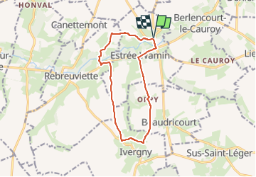
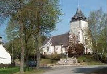
Trail Walking of 11.2 km to be discovered at Hauts-de-France, Pas-de-Calais, Estrée-Wamin. This trail is proposed by temmichel.

Description

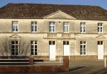
Randonnée au départ de l'église d'ESTREE-WAMIN pour rejoindre par le GR 121 les abords du village d'IVERGNY situé sur l'autre rive de la Canche. De là, cheminer jusqu'à la ferme des Sertelles par la voie Comtesse et redescendre vers la Canche en restant vigilant sur la D79 avant de rejoindre le point de départ
Bonne randonnée
Jean-Michel

Elevation profile

Photos

Positioning

Country:
France
Region :
Hauts-de-France
Department/Province :
Pas-de-Calais
Municipality :
Estrée-Wamin
Location:
Unknown
Start:(UTM)
457334 ; 5569342 (31U) N.

Trails nearby

Trail Walking Sus-Saint-Léger - Sentier du Petit Dieu - Sus-Saint-Léger - Photo
Walking
tracegps

Walking

Medium
Sus-Saint-Léger, Hauts-de-France, Pas-de-Calais, France
11.8 km | 12.9 km-effort
2h 55min
Yes
Trail Walking Berlencourt-le-Cauroy - Le sentier du loup (Berlencourt-le-cauroy) - Photo
Walking
tracegps

Walking

Difficult
Berlencourt-le-Cauroy, Hauts-de-France, Pas-de-Calais, France
15.2 km | 17.3 km-effort
3h 45min
Yes
Trail Walking Canettemont - CANETTEMONT (62) Le chemin de Saint Pol - Photo
Walking
temmichel

Walking

Medium
Canettemont, Hauts-de-France, Pas-de-Calais, France
8.2 km | 8.9 km-effort
2h 1min
Yes
Trail Walking Rebreuviette - REBREUVE SUR CANCHE - Les Champs Graux - Photo
Walking
temmichel

Walking

Difficult
Rebreuviette, Hauts-de-France, Pas-de-Calais, France
11.2 km | 12.6 km-effort
2h 51min
Yes
Trail Walking Sus-Saint-Léger - LUCHEUX et sa forêt - Photo
Walking
camino59

Walking

Easy
Sus-Saint-Léger, Hauts-de-France, Pas-de-Calais, France
14.8 km | 17.2 km-effort
3h 49min
Yes
Trail Walking Berlencourt-le-Cauroy - Berlencourt/Lucheux 23Kms Dén P 266m - Photo
Walking
alain62rando

Walking

Medium
Berlencourt-le-Cauroy, Hauts-de-France, Pas-de-Calais, France
23 km | 27 km-effort
5h 49min
No
Trail Walking Berlencourt-le-Cauroy - La Cauroy 11.3Kms Dén P 134m - Photo
Walking
alain62rando

Walking

Easy
Berlencourt-le-Cauroy, Hauts-de-France, Pas-de-Calais, France
11.5 km | 13.2 km-effort
2h 54min
Yes


Close
My subscriptions