![](/images/other/stat-length.png)
![Trail Road bike Ollioules - Parcours 1A - Photo](https://media.geolcdn.com/t/1900/400/ext.pjpeg?maxdim=2&url=https%3A%2F%2Fstatic1.geolcdn.com%2Fsiteimages%2Fupload%2Ffiles%2F1524743154velo.jpg)
Parcours 1A
JPBLATGE
User
![Length](/images/other/stat-length.png)
Length
49 km
![Max alt](https://static1.geolcdn.com/siteimages/upload/files/1508320355ic_sort_altitude_max_24dp.png)
Max alt
240 m
![Uphill gradient](https://static1.geolcdn.com/siteimages/upload/files/1508320355ic_sort_den_pos_24dp.png)
Uphill gradient
669 m
![Km-Effort](/images/other/stat-length.png)
Km-Effort
58 km
![Min alt](https://static1.geolcdn.com/siteimages/upload/files/1508320355ic_sort_altitude_min_24dp.png)
Min alt
22 m
![Downhill gradient](https://static1.geolcdn.com/siteimages/upload/files/1508320355ic_sort_den_neg_24dp.png)
Downhill gradient
668 m
![Boucle](https://static1.geolcdn.com/siteimages/upload/files/16400158638029165_repeat_loop_refresh_sync_direction_icon.png)
Boucle
Yes
Creation date :
2024-03-26 14:44:15.674
Updated on :
2024-04-01 17:30:00.186
![Road bike](https://static1.geolcdn.com/sitytour/trail-icons/201.png)
3h31
Difficulty : Very difficult
![Scan this QR Code to open this trail in the SityTrail application](https://capi.geolives.com/qq0zvz2zws4bq2lad0pu/sitytour/trails/3994605/qr.png?size=200)
FREE GPS app for hiking
About
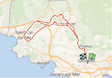
Trail Road bike of 49 km to be discovered at Provence-Alpes-Côte d'Azur, Var, Ollioules. This trail is proposed by JPBLATGE.
Description
Ollioules, Les Gorges, Le Beausset, Le Castellet, Ch. Pin Vieux, La Cadière, St Côme, St Cyr centre, Ch. Des Vignes, Le long de l'autoroute, Le Brûlat, Vallée du Silence, Le Beausset, Les Gorges, Ollioules.
Positioning
Country:
France
Region :
Provence-Alpes-Côte d'Azur
Department/Province :
Var
Municipality :
Ollioules
Location:
Unknown
Start:(Dec)
Start:(UTM)
731876 ; 4779716 (31T) N.
Comments
Trails nearby
![Trail Walking Ollioules - SityTrail - 1041295 - le-destel-grotte-des-joncs - Photo](https://media.geolcdn.com/t/375/260/b00c002a-3425-4f84-ae24-7620ef9e7315.jpg&format=jpg&maxdim=2)
![Walking Walking](https://static1.geolcdn.com/sitytour/trail-icons/101.png)
SityTrail - 1041295 - le-destel-grotte-des-joncs
Walking
Medium
(1)
Ollioules,
Provence-Alpes-Côte d'Azur,
Var,
France
![](/images/other/stat-length.png)
11.8 km | 19.3 km-effort
4h 23min
![](https://static1.geolcdn.com/siteimages/upload/files/16400158638029165_repeat_loop_refresh_sync_direction_icon.png)
Yes
![Trail Walking Évenos - SityTrail - st anne d'evenos. - Photo](https://media.geolcdn.com/t/375/260/1a61a6ef-600e-4900-ae4e-54737b695f44.jpg&format=jpg&maxdim=2)
![Walking Walking](https://static1.geolcdn.com/sitytour/trail-icons/101.png)
SityTrail - st anne d'evenos.
Walking
Difficult
(1)
Évenos,
Provence-Alpes-Côte d'Azur,
Var,
France
![](/images/other/stat-length.png)
13 km | 18.7 km-effort
4h 15min
![](https://static1.geolcdn.com/siteimages/upload/files/16400158638029165_repeat_loop_refresh_sync_direction_icon.png)
Yes
![Trail Walking Six-Fours-les-Plages - ND de Pepiole via colline du fort de Six-Fours, retour par Les Lônes - Photo](https://media.geolcdn.com/t/375/260/1379151f-75a9-4587-8d69-64d0542e06ca.jpg&format=jpg&maxdim=2)
![Walking Walking](https://static1.geolcdn.com/sitytour/trail-icons/101.png)
ND de Pepiole via colline du fort de Six-Fours, retour par Les Lônes
Walking
Easy
(1)
Six-Fours-les-Plages,
Provence-Alpes-Côte d'Azur,
Var,
France
![](/images/other/stat-length.png)
8.2 km | 10.7 km-effort
3h 0min
![](https://static1.geolcdn.com/siteimages/upload/files/16400158638029165_repeat_loop_refresh_sync_direction_icon.png)
Yes
![Trail Walking Toulon - Tour Du Baou par falaises - Photo](https://media.geolcdn.com/t/375/260/ext.jpg?maxdim=2&url=https%3A%2F%2Fservices.sitytrail.com%2FGeolivesWS%2FDownloadMedia.ashx%3FTrailID%3D166161%26Media%3D20121215151840.jpeg)
![Walking Walking](https://static1.geolcdn.com/sitytour/trail-icons/101.png)
Tour Du Baou par falaises
Walking
Medium
(1)
Toulon,
Provence-Alpes-Côte d'Azur,
Var,
France
![](/images/other/stat-length.png)
7.3 km | 11.3 km-effort
2h 10min
![](https://static1.geolcdn.com/siteimages/upload/files/16400158638029165_repeat_loop_refresh_sync_direction_icon.png)
Yes
![Trail Walking Six-Fours-les-Plages - ND de Pepiole via colline du fort de Six-Fours - Photo](https://media.geolcdn.com/t/375/260/1379151f-75a9-4587-8d69-64d0542e06ca.jpg&format=jpg&maxdim=2)
![Walking Walking](https://static1.geolcdn.com/sitytour/trail-icons/101.png)
ND de Pepiole via colline du fort de Six-Fours
Walking
Easy
(1)
Six-Fours-les-Plages,
Provence-Alpes-Côte d'Azur,
Var,
France
![](/images/other/stat-length.png)
8.7 km | 12.3 km-effort
3h 0min
![](https://static1.geolcdn.com/siteimages/upload/files/16400158638029165_repeat_loop_refresh_sync_direction_icon.png)
Yes
![Trail Walking Évenos - Le broussan croupatier fin randonnée - Photo](https://media.geolcdn.com/t/375/260/ec3fd25e-452d-47c7-8bcf-accd29bcb68e.jpg&format=jpg&maxdim=2)
![Walking Walking](https://static1.geolcdn.com/sitytour/trail-icons/101.png)
Le broussan croupatier fin randonnée
Walking
Medium
(3)
Évenos,
Provence-Alpes-Côte d'Azur,
Var,
France
![](/images/other/stat-length.png)
10.6 km | 14.9 km-effort
5h 18min
![](https://static1.geolcdn.com/siteimages/upload/files/16400158638029165_repeat_loop_refresh_sync_direction_icon.png)
Yes
![Trail Walking Évenos - Sainte Anne d'Evenos Le Gros Cerveau - Photo](https://media.geolcdn.com/t/375/260/ext.jpg?maxdim=2&url=https%3A%2F%2Fservices.sitytrail.com%2FGeolivesWS%2FDownloadMedia.ashx%3FTrailID%3D104105%26Media%3D7169_2.jpg)
![Walking Walking](https://static1.geolcdn.com/sitytour/trail-icons/101.png)
Sainte Anne d'Evenos Le Gros Cerveau
Walking
Difficult
(3)
Évenos,
Provence-Alpes-Côte d'Azur,
Var,
France
![](/images/other/stat-length.png)
7 km | 11.8 km-effort
3h 30min
![](https://static1.geolcdn.com/siteimages/upload/files/16400158638029165_repeat_loop_refresh_sync_direction_icon.png)
Yes
![Trail Walking Évenos - Cap Gros et tour des Quatres Auros - Photo](https://media.geolcdn.com/t/375/260/94f2bd7e-0591-43bc-81db-9dab0e95183a.jpg&format=jpg&maxdim=2)
![Walking Walking](https://static1.geolcdn.com/sitytour/trail-icons/101.png)
Cap Gros et tour des Quatres Auros
Walking
Medium
Évenos,
Provence-Alpes-Côte d'Azur,
Var,
France
![](/images/other/stat-length.png)
7 km | 12.6 km-effort
2h 41min
![](https://static1.geolcdn.com/siteimages/upload/files/16400158638029165_repeat_loop_refresh_sync_direction_icon.png)
Yes
![Trail Walking Évenos - 83 grès ste anne - Photo](https://media.geolcdn.com/t/375/260/4065f763-de74-4ec5-8986-258e029c817d.jpg&format=jpg&maxdim=2)
![Walking Walking](https://static1.geolcdn.com/sitytour/trail-icons/101.png)
83 grès ste anne
Walking
Medium
Évenos,
Provence-Alpes-Côte d'Azur,
Var,
France
![](/images/other/stat-length.png)
3.4 km | 6.1 km-effort
2h 23min
![](https://static1.geolcdn.com/siteimages/upload/files/16400158638029165_repeat_loop_refresh_sync_direction_icon.png)
Yes