Trail Walking Puiseux-le-Hauberger - Puiseux le Hauberger_La Fosse St Clair_Trace GPS simplifiée_10,2Km - Photo

Puiseux le Hauberger_La Fosse St Clair_Trace GPS simplifiée_10,2Km

© OpenStreetMap contributors
Length
Length
11.1 km
Max alt
Max alt
161 m
Uphill gradient
Uphill gradient
193 m
Km-Effort
Km-Effort  
13.7 km
Min alt
Min alt
62 m
Downhill gradient
Downhill gradient
194 m
Boucle
Boucle
Yes
Creation date :
2015-03-24 00:00:00.0
Updated on :
2015-03-24 00:00:00.0

(0 Reviews)

Walking
Walking
2h53
Difficulty : Medium

Scan this QR Code to open this trail in the SityTrail application

FREE GPS app for hiking

Logo SityTrail SityTrail

IGN / Geographical institutes

Download SityTrail from the App Store Download SityTrail from Google Play

Logo SityTrail SityTrail World

The world is yours!

Download SityTrail from the App Store Download SityTrail from Google Play Download SityTrail on Huawei AppGallery

About

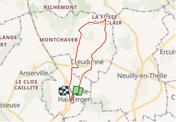
Trail Walking of 11.1 km to be discovered at Hauts-de-France, Oise, Puiseux-le-Hauberger. This trail is proposed by Pousscailleux.

Description

Départ le long de la "Grande Rue", près de l'église de Puiseux.
Itinéraire établi d'après le dépliant "Pays de Thelle, Côté Nature - Randonnée, Circuit Puiseux - Dieudonné"

Elevation profile

Positioning

Country:
France
Region :
Hauts-de-France
Department/Province :
Oise
Municipality :
Puiseux-le-Hauberger
Location:
Unknown
Start:(UTM)
444325 ; 5451393 (31U) N.

Trails nearby

Trail Walking Neuilly-en-Thelle - La Vallée de Noé - Neuilly-en-Thelle - Photo
Walking
tracegps

Walking

Difficult
(1)
Neuilly-en-Thelle, Hauts-de-France, Oise, France
13.5 km | 16.1 km-effort
3h 30min
Yes
Trail Mountain bike Bornel - Le Chemin d'Angleterre - Bornel - Photo
Mountain bike
tracegps

Mountain bike

Medium
(1)
Bornel, Hauts-de-France, Oise, France
43 km | 49 km-effort
3h 0min
Yes
Trail Walking Neuilly-en-Thelle - La Vallée de Noé - Neuilly en Thelle - Photo
Walking
tracegps

Walking

Medium
(1)
Neuilly-en-Thelle, Hauts-de-France, Oise, France
13.5 km | 16.1 km-effort
3h 30min
Yes
Trail Walking Chambly - Chambly - Photo
Walking
avdem

Walking

Easy
Chambly, Hauts-de-France, Oise, France
17 km | 19.3 km-effort
2h 29min
No
Trail Walking Ronquerolles - ronquerolles - Photo
Walking
louis-guy Michineau

Walking

Medium
(1)
Ronquerolles, Ile-de-France, Val-d'Oise, France
6.3 km | 7.4 km-effort
1h 34min
Yes
Trail Walking Chambly - Chambly Gabdicourt, Ronquerole - Photo
Walking
avdem

Walking

Medium
Chambly, Hauts-de-France, Oise, France
8.9 km | 10.1 km-effort
2h 5min
No
Trail Walking Bornel - Fosseuse Anservkille - Photo
Walking
avdem

Walking

Very easy
Bornel, Hauts-de-France, Oise, France
11.4 km | 13.3 km-effort
2h 38min
No
Trail Walking Ronquerolles - écurie ronquerolles - Photo
Walking
doloop

Walking

Difficult
(1)
Ronquerolles, Ile-de-France, Val-d'Oise, France
11.2 km | 13.8 km-effort
2h 58min
Yes
Trail Walking Puiseux-le-Hauberger - Circuit de Puiseux-Dieudonné  -  Puiseux-le-Hauberger - Photo
Walking
tracegps

Walking

Medium
(2)
Puiseux-le-Hauberger, Hauts-de-France, Oise, France
11.2 km | 13.7 km-effort
2h 49min
Yes


Close
My subscriptions